Maps
and Imagery Intelligence
|
|
|
This website
will post a number of useful maps, charts and images.
|
|
|
Australian and Regional Maps
|
|

|
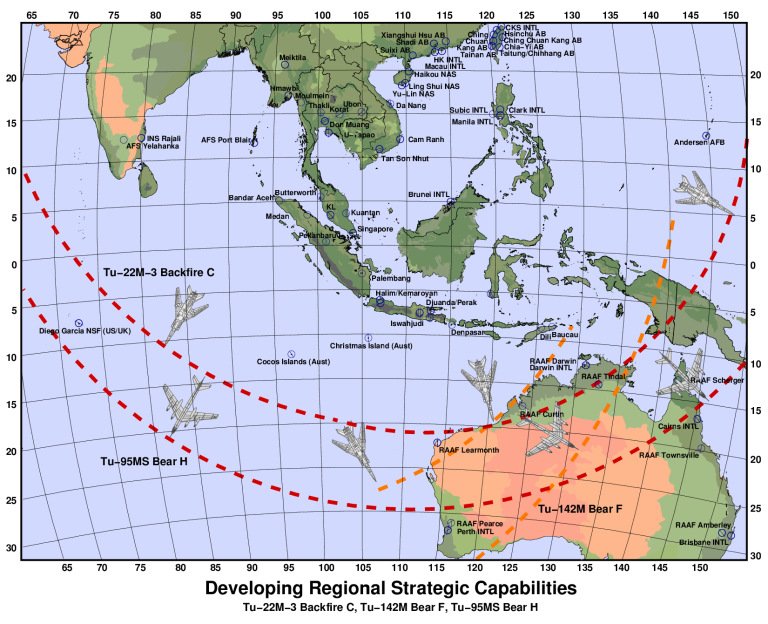
The
now certain deployment of strategic bombers by the PLA-AF will
fundamentally alter the strategic balance in the near region. This map
illustrates the coverage footprint of the Tu-95MS Bear H and Tu-22M-3
Backfire C flown from southern China and Myanmar basing. The footprint
of Indian deployments of like types is included for comparison (C. Kopp).
|

|
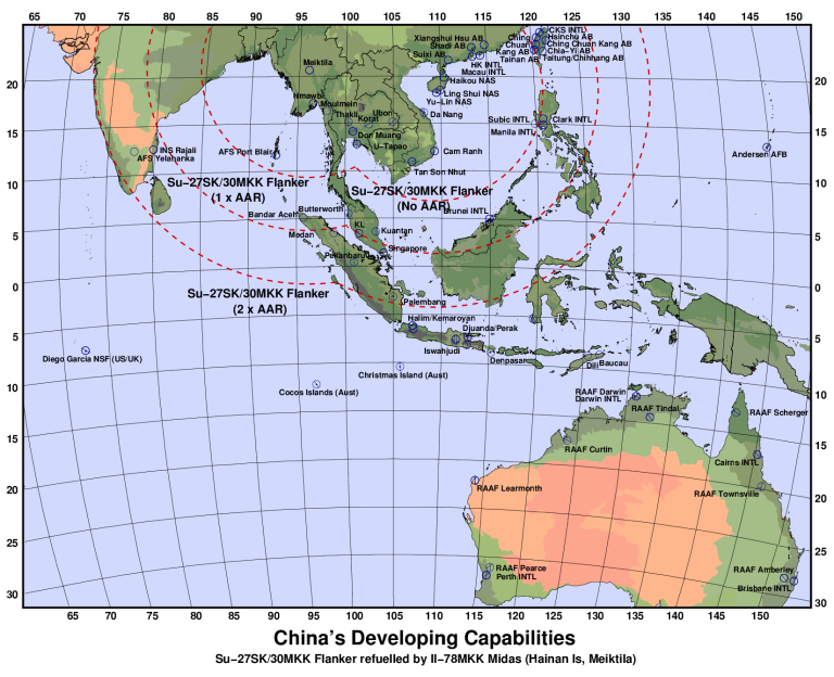
The
acquisition of long range Su-27SK/30MKK fighters and supporting
Il-78MKK aerial refuelling tankers provides the PLA-AF with
unprecedented reach across the near region (C. Kopp).
|

|
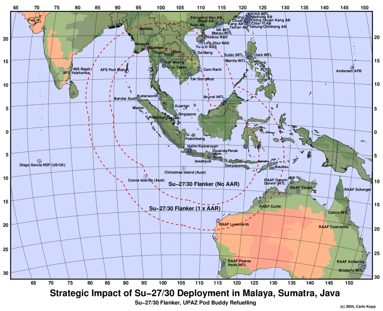
The
arrival of the Su-27/30 series fighters in this region changes
Australia's strategic context significantly. The superb combat radius of
these large aircraft provides a significant capability to cover
the sea-air gap (Author C. Kopp).
|
|
 |
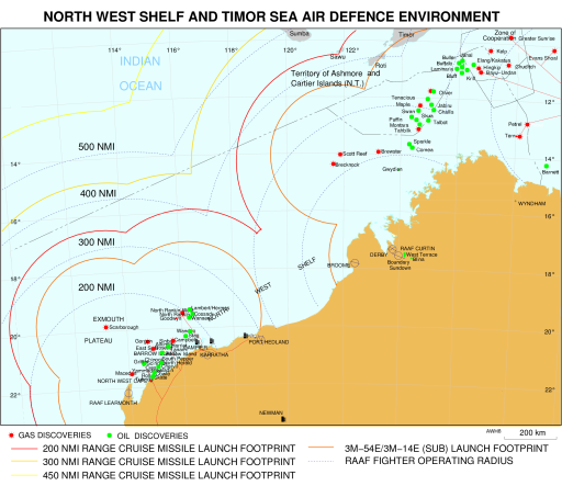
| North West Shelf and Timor Sea area map
depicting key oil, gas and airfield installations. Overlays include
launch footprints for cruise missiles with ranges of 160, 200, 300 and
450 nautical miles, and radius circles from RAAF bases at Learmonth,
Curtin, and Tindal (Author C. Kopp). |
|
|
IMINT Links
|
|
| IMINT
Gallery @ GlobalSecurity.org |
|
| Map Links |
|
University of Texas, Austin -
Perry-Castañeda Library Map Collection - Iraq Maps
|
| University of Texas, Austin -
Perry-Castañeda Library Map Collection - Maps of Australia
and the Pacific |
| University of Texas, Austin -
Perry-Castañeda Library Map Collection - Asia Maps |
|
|
|
|
![Home - Air Power Australia Website [Click for more ...]](APA/APA-Title-Main.png)
![Sukhoi PAK-FA and Flanker Index Page [Click for more ...]](APA/flanker.png)
![F-35 Joint Strike Fighter Index Page [Click for more ...]](APA/jsf.png)
![Weapons Technology Index Page [Click for more ...]](APA/weps.png)
![News and Media Related Material Index Page [Click for more ...]](APA/media.png)
![Surface to Air Missile Systems / Integrated Air Defence Systems Index Page [Click for more ...]](APA/sams-iads.png)
![Ballistic Missiles and Missile Defence Page [Click for more ...]](APA/msls-bmd.png)
![Air Power and National Military Strategy Index Page [Click for more ...]](APA/strategy.png)
![Military Aviation Historical Topics Index Page [Click for more ...]](APA/history.png)
![Intelligence, Surveillance and Reconnaissance and Network Centric Warfare Index Page [Click for more ...]](APA/isr-ncw.png)
![Information Warfare / Operations and Electronic Warfare Index Page [Click for more ...]](APA/iw.png)
![Systems and Basic Technology Index Page [Click for more ...]](APA/technology.png)
![Related Links Index Page [Click for more ...]](APA/links.png)
![Homepage of Australia's First Online Journal Covering Air Power Issues (ISSN 1832-2433) [Click for more ...]](APA/apa-analyses.png)


![Sukhoi PAK-FA and Flanker Index Page [Click for more ...]](APA/flanker.png)
![F-35 Joint Strike Fighter Index Page [Click for more ...]](APA/jsf.png)
![Weapons Technology Index Page [Click for more ...]](APA/weps.png)
![News and Media Related Material Index Page [Click for more ...]](APA/media.png)
![Surface to Air Missile Systems / Integrated Air Defence Systems Index Page [Click for more ...]](APA/sams-iads.png)
![Ballistic Missiles and Missile Defence Page [Click for more ...]](APA/msls-bmd.png)
![Air Power and National Military Strategy Index Page [Click for more ...]](APA/strategy.png)
![Military Aviation Historical Topics Index Page [Click for more ...]](APA/history.png)
![Information Warfare / Operations and Electronic Warfare Index Page [Click for more ...]](APA/iw.png)
![Systems and Basic Technology Index Page [Click for more ...]](APA/technology.png)
![Related Links Index Page [Click for more ...]](APA/links.png)
![Homepage of Australia's First Online Journal Covering Air Power Issues (ISSN 1832-2433) [Click for more ...]](APA/apa-analyses.png)