|
||||||||||||||||||||||
![Australia's First Online Journal Covering Air Power Issues [ISSN 1832-2433]](APA/APA-Title-Analyses.png "Australia's First Online Journal Covering Air Power Issues [ISSN 1832-2433]") |
||||||||||||||||||||||
 |
 |
 |
 |
 |
 |
 |
 |
|||||||||||||||
 |
 |
 |

|
 |
 |
 |
 |
|||||||||||||||
| Last Updated: Mon Jan 27 11:18:09 UTC 2014 | ||||||||||||||||||||||
|
||||||||||||||||||||||
|
||||||||||||||||||||||
|
||||||||||||||||||||||
|
|
|
|
|
|
|
|
|||||||||||||||
|
|
|
|
|
|
|
|
|||||||||||||||
| Last Updated: Mon Jan 27 11:18:09 UTC 2014 | ||||||||||||||||||||||
|
||||||||||||||||||||||
| Basing Infrastructure Considerations in the Defence of Australia's Indian Ocean Approaches |
||||||||||||||||||||
|
||||||||||||||||||||
|
|
||||||||||||||||||||
|
||||||||||||||||||||
Index |
||||||||||||||||||||
|
||||||||||||||||||||
Introduction |
||||||||||||||||||||
| The changing
strategic environment in Asia is producing deep force structure focus
and posture changes in the United States military, and that of many
regional nations. Mostly this is a byproduct of the remarkable speed,
scale and scope of China's military capability growth, but also a
byproduct of a concurrent parallel growth pattern in capabilities
across Asia, in response to China's growth. In many respects, this
represents incremental escalation of the “creeping arms race” which has
characterised the military environment in Asia since the end of the
Cold War. Australia can no longer assume that these changes are not relevant to her strategic position, and the Australian Defence Force Posture Review (ADFPR) which is to report in early 2012 is an important step forward in aligning Australia's posture to a changing region. This study explores the problem of determining an optimal basing arrangement for Royal Australian Air Force and Royal Australian Navy assets in the Indian Ocean region, in considerably greater depth and detail than is feasible in an effort such as the ADFPR, which by its nature is constrained. Given the considerable cost of basing construction and long term maintenance, determining an optimal basing arrangement is not a trivial problem. Poor choices would impose serious constraints on the ability of the ADF to operate in the Indian Ocean, deny options in supporting United States alliance commitments, and incur unnecessary and large expenditures of resources during a period of fiscal difficulty, when the ADF force structure is being recapitalised. Therefore, this study aims to explore the full range of critical problems which must be addressed in producing the best possible outcome, in terms of long term capability and flexibility. The strategic context is explored in detail, both in the regional context, and in the context of the exceptional growth seen in the Pilbara and Kimberley. The historical background to Australian, United States and British basing in the Eastern Indian Ocean is surveyed. Strategic considerations for basing in the Pilbara, Kimberley and Indian Ocean Offshore Territories are explored and analysed, and best outcomes identified. Specific environmental and operational problems for key sites are analysed, including critical environmental constraints. Finally, the ADFPR Interim Report recommendations are tested against the findings of this study. Additional reference material is included in a series of Annexes, including a discussion of airbase hardening problems and options, and extant United States island basing arrangements. |
||||||||||||||||||||
The Strategic Importance of the Indian Ocean SLOCs |
||||||||||||||||||||
| The
industrialisation of Asia began with Japan during the 1920s, and has
been an accelerating process as South Korea, Taiwan, and most recently
mainland China have pursued industrialisation, with India following.
These
Asian nations collectively now account for much of global manufacturing
activity, in areas ranging from heavy industries such metal processing
and shipbuilding, down to the operation of high density
microelectronic foundries. A key characteristic of industrial economies is that they are insatiable consumers of energy and raw materials. This reality was observed first during the industrialisation of Europe, then during the industrialisation of North America, and most recently, during the industrialisation of Asia. The consequence of this is high per capita energy consumption in most if not all industrialised nations, spread across transportation, industrial manufacturing, and consumer markets. Other consequences of industrialisation are a strong drive to individual ownership of housing and automobiles. In turn this yields higher energy consumption and thus increased demand over time as a result. It is often not well understood that one of the major motivations underpinning the Great War was intensive competition over colonial raw materials and energy, between the established colonial powers, and latecomers on the European continent. The Second World War, while most commonly explained as a clash between diametrically opposed ideologies, was motivated in a large part by German and Japanese demand for raw materials and energy, controlled at that time by the Western powers and Soviets. The German drive to Stalingrad, and the Japanese occupation of South East Asia, were both intended to secure energy supplies. The grand geostrategic plays of the Cold War involved the West and Warsaw Pact nations fighting across the developing world. Underpinning these ostensibly ideologically motivated conflicts was a contest for the control of key naval chokepoints, and very frequently, access to local energy or mineral resources. While Soviet rhetoric was centred in ideology, practical strategic choices were clearly driven by other agendas, as demonstrated by the Gorshkov doctrine, which clearly stated that “the interdiction of merchant shipping and its associated escorts is the most important constituent part of the efforts of a fleet aimed at undermining the military/economic potential of the enemy” [1]. The three great conflicts of twentieth century were thus at the most fundamental level the result of competition over access to energy and resources. 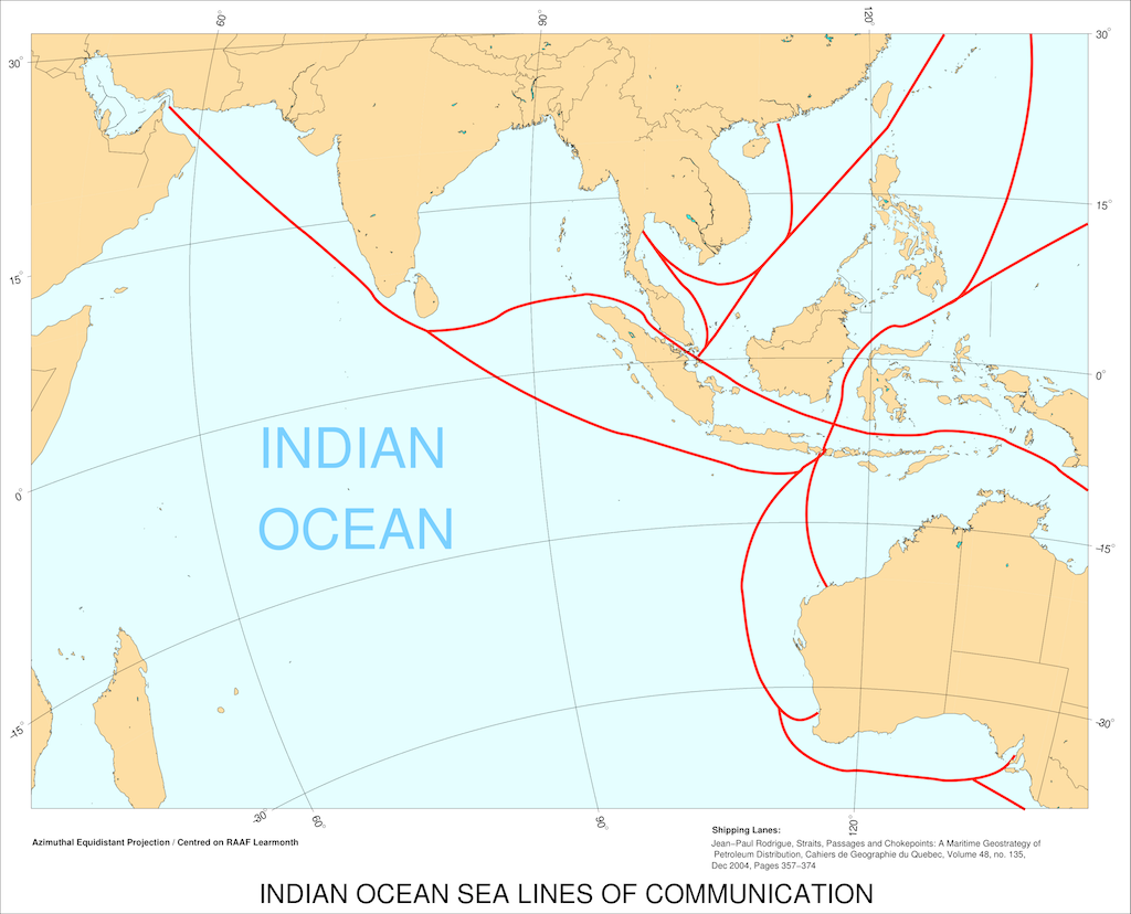 Figure 1. Primary Indian Ocean
SLOCs (C.
Kopp).
It may be argued, that the Indian Ocean is at this time carrying more maritime traffic than any other water body of its size. Much of this traffic comprises oil tankers and LNG tankers travelling to and from Persian Gulf terminals, enroute to Europe, and importantly, the industrial economies of the Far East. Rodrigue's detailed study of the global shipping infrastructure shows that Asia is now the predominant destination for Middle Eastern petroleum/gas product. Even one decade ago Asian consumption of Middle Eastern oil was of the order of twice that of the European Union [2]. Most of the crude oil and LNG produced in the Persian Gulf and destined for Asia is shipped through the Straits of Hormuz, past the southern tip of the Indian subcontinent, and then via the Straits of Malacca, Sunda or Lombok in the Indonesian archipelago, and thereafter via lanes in the South China Sea, or lanes east of the Philippines, to terminals in China, Taiwan, South Korea and Japan. Container ships carrying manufactured goods from Asia to Europe and Africa will also traverse these shipping lanes, as the shortest great circle path is the cheapest route in terms of fuel consumption, a major cost factor. Minerals and ores mined in Africa and destined for Asia will also travel via the Indian Ocean sea lanes. These traffic patterns in shipping will persist for at least two decades, until Persian Gulf oil and gas reserves are exhausted and other regions become dominant POL and LNG suppliers to Asian economies. Persian Gulf oil reserves have crossed the “peak oil” point and these oilfields are now declining in output, as they are progressively exhausted. Recent and well publicised discoveries in the Americas of oil and gas in offshore locations, and onshore oil and gas bearing shales, could well see a return to the global dominance of the Americas as the world's biggest energy producing region [3]. Importantly, in situ known reserves are not a measure of immediate or near term production capacity, and until these discoveries are further developed, the Persian Gulf will remain a critical energy producing region, with all of the strategic consequences that entails. Asia's lack of self-sufficiency in fossil fuels is a pivotal strategic vulnerability for all of these nations, but especially China, where the nation's sheer size drives up the demand for energy to fuel its transportation infrastructure, and military machine. China has some domestic oil reserves in East Turkmenistan, and is contesting access to some seabed reserves across the South China Sea. China is also initiated construction of the world's largest Fischer-Tropsch synthetic fuel plant, intended to use coal as a feedstock [4]. For the foreseeable future China will remain heavily dependent upon oil and LNG imports, with Iran and likely Australia key LNG suppliers. At this time more than 50% of China's oil imports arrive via the Indian Ocean, from Saudi Arabia, Iran and Angola. Current projections suggest that two thirds of China's oil consumption will be imports by 2030, while currently half is imported [5][6]. The unavoidable strategic reality is that any nation or alliance which can control the sea lanes of the Indian Ocean can hold much of Asia hostage, including China. Control of the western Indian Ocean closes the chokepoint at the Arabian Sea, while control of the eastern Indian Ocean closes the chokepoints in the Indonesian archipelago. The means via which the chokepoints at the eastern and western extremities of the Indian Ocean might be closed are manifold: by coastal missile batteries, land based air power, submarines, surface warships, naval mines or some combination of these measures, with much the same strategic impact. The flow of crude oil and LNG can be constricted, controlled or completely halted by the controlling party. In historical terms, the Royal Navy was the first to hold a dominant position in the Indian Ocean, displaced during the Cold War by the US Navy replenishing from Diego Garcia in the British Indian Ocean Territories, and the Soviet Voenno-Morskii Flot operating from Goa in India. The Soviets long sought a land accessible port in the region, but failed to secure one [7]. Reflecting the strategic importance of the Indian Ocean, China has invested heavily in “special relationships” with both Pakistan and Burma, and has actively cultivated Iran despite the political risks involved. The is frequently described as the “String of Pearls” strategy, whereby a chain of bases is built along China's most critical strategic SLOCs. Burma has seen upgrades to its airfields and ports, paid for by China, well in excess of any domestic needs. More recently, China commenced construction of an oil and LNG terminal at Kyuakpya in Burma, in the Bay of Bengal, connected by pipeline to Kunming in China. This facility will reduce the recurring shipping cost, but also bypass the eastern chokepoint [8]. Reports emerged in 2011 suggesting that China may seek naval basing in Pakistan, at the deep water port of Gwadar in Baluchistan, a former enclave of Oman purchased by Pakistan in 1958. The port was subjected to a major upgrade in recent years and is capable of accommodating vessels with a draft of up to 14 metres [9] [10]. India has always maintained a strong naval and maritime patrol capability, intended in part to blockade Pakistan in time of war. India has upgraded facilities in the Andaman Islands, to extend its footprint. It recently ordered new P-8I Poseidon LRMP/ASW aircraft in the US, abandoning a long established relationship with Russian suppliers. There can be little doubt at this time that competition for control of the Indian Ocean is now well established. |
||||||||||||||||||||
A Strategic Perspective on the Indian Ocean |
||||||||||||||||||||
| The greatest challenge Australia must confront
in coming decades will be maintaining a secure strategic position in
the Asia-Pacific region. The industrialisation and economic growth of
Asia is an ongoing process which will not cease in the foreseeable
future. The inevitable byproduct of economic growth will be ongoing
high military capital equipment investments across Asia. The defacto unregulated supply of Russian and Chinese built high technology weapons, which are sold both for profit and strategic influence, creates an environment where any nation in Asia, or elsewhere, can procure almost any advanced system, and the digital technology employed in the construction of such systems removes most if not all of the training and support impediments which hampered the effectiveness of Soviet era weapons during the Cold War, and immediate post Cold War period [11]. An important aspect of the military modernisation of Asia has been a significant increase in the effective operational reach of weapon systems. To emphasise this point, a Kilo class SSK with a cruise missile armament is not a reverse engineered Romeo class U-boat, and a new-build Sukhoi Su-35S Flanker with F-111 class range is not a 200 nautical mile radius MiG-21 Fishbed or clone thereof. Through most of the Cold War period distance protected Australia from most capabilities deployed in Asia. This is much less the case today - any number of weapon systems deployed in Asia can now cross Australia's sea-air gap with no difficulty, and strike at military installations, infrastructure and northern population centres. It is now inevitable that the coming decades will be a period of strategic competition across Asia, involving nascent China and India, smaller nations across Asia, and the United States. Much of this competition will be driven by access to energy, be it in situ seabed reserves, or SLOCs employed for importing energy from the Middle East and Africa. The intensity of this competition should not be underestimated. In September of 2011, an editorial in a major Chinese Communist Party newspaper, the Global Times, stated: “the South China Sea is the best place for China to wage wars” as “of the more than 1,000 oil rigs there, none belongs to China; of the four airfields in the Spratly Islands, none belongs to China; once a war is declared, the South China Sea will be a sea of fire. Who will suffer the most from a war? Once a war starts there, the Western oil companies will flee the area, who will suffer the most?”.[12] Since the end of the Cold War, Australia has had the indulgence of not having to confront the risk of a high intensity regional conflict. The consequence of this is that Australia's Defence planning drifted into a “comfort zone” where minimal force structure and infrastructure, geared around Indonesia's capabilities, became the accepted norm. The use of Indonesia's capabilities as a force structure benchmark remains a common predilection in Canberra Defence circles, in practice, even if public statements claim otherwise. This has been, in every respect, a mistake, as Indonesia is not a representative example of the uptake of advanced Russian and Chinese weapons technology in Asia. It does however provide a justification for minimising capability and avoiding proper short, medium and long term planning choices especially in force structure planning. As much as the idea of Australia being a niche or boutique provider of specialised capabilities, such as Special Forces or airlift, to United States led coalition forces may be appealing in some circles, it leads to a deep distortion of planning priorities and loss of focus. One parliamentarian remarked to this author, that “...becoming America's Gurkhas will do nothing for Australia's strategic position, or improve America's strategic posture in the Indo-Pacific region”. To properly and robustly address the changing strategic environment will require considerable thought, much planning, and careful investment, both in capabilities and infrastructure. The determination of what investment is appropriate must reflect strategic needs, as well as Australia's assets and vulnerabilities in the Indian Ocean region. |
||||||||||||||||||||
Western Australia and the Indian Ocean |
||||||||||||||||||||
| Western
Australia and the Cocos (Keeling) Islands, then British and now an
Australian offshore territory, played an important role during the
Second World War, as a staging area and basing area for air and
naval operations across South East Asia. Western Australia was a critical strategic asset during that period. It was also an asset with few vulnerabilities, as the North-West was very sparsely populated with an economy dominated by agriculture, specifically cattle stations. RAAF and naval basing in the Pilbara and Kimberley regions were the only significant targets the Japanese could damage, as there were no assets of strategic economic importance in the state. That was 70 years in the past. At this time is the North-West has become one of Australia's most valuable economic assets and sources of export revenue, with a growing population. Western Australia has become a major centre for the resource industry, on a scale without precedent. The state is a major exporter of iron ore, oil/condensate and LNG, gold, nickel, alumina, diamonds, manganese, chromite, tantalum, lithium, copper, vanadium and rare earths. These are strategically important raw materials and valuable exports from Western Australia. [13][14].
Iron ore has been a major export from the Pilbara region, for many decades, and the known reserves are expected to last for decades. Decades of sustained infrastructure development and heavy industrial manufacturing, especially shipbuilding, have seen strong and ongoing demand in Asia, especially China. The Kimberley region is claimed to produce almost a third of global diamond production, and is often regarded to be the largest single supplier globally. The Kimberley region is also home to other mineral mining operations, and the Ord river irrigation scheme supports tropical crop farming.  Figure 3. Western Australia (1936).
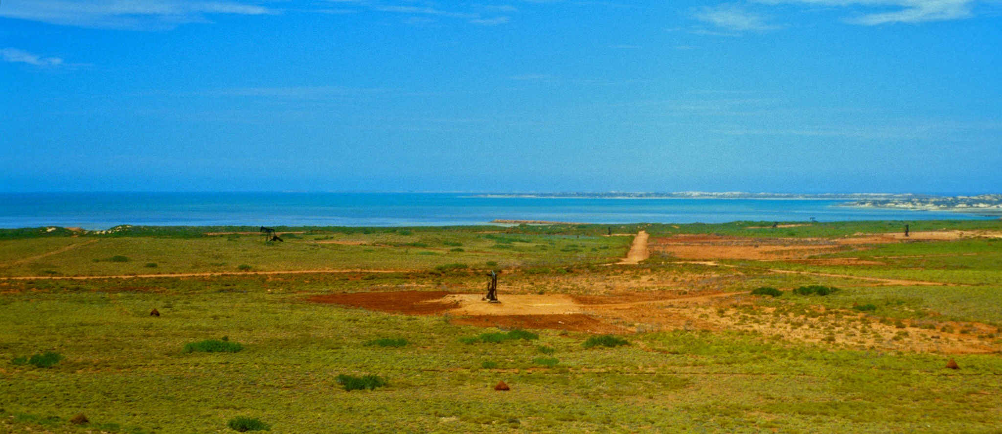 Figure 4, 5: Above, below: the Barrow Island oilfield was the first major energy industry development in the Pilbara, operated by W.A. Petroleum (WAPET), later absorbed by Chevron (© 1979 - 2012 Carlo Kopp). 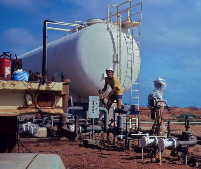 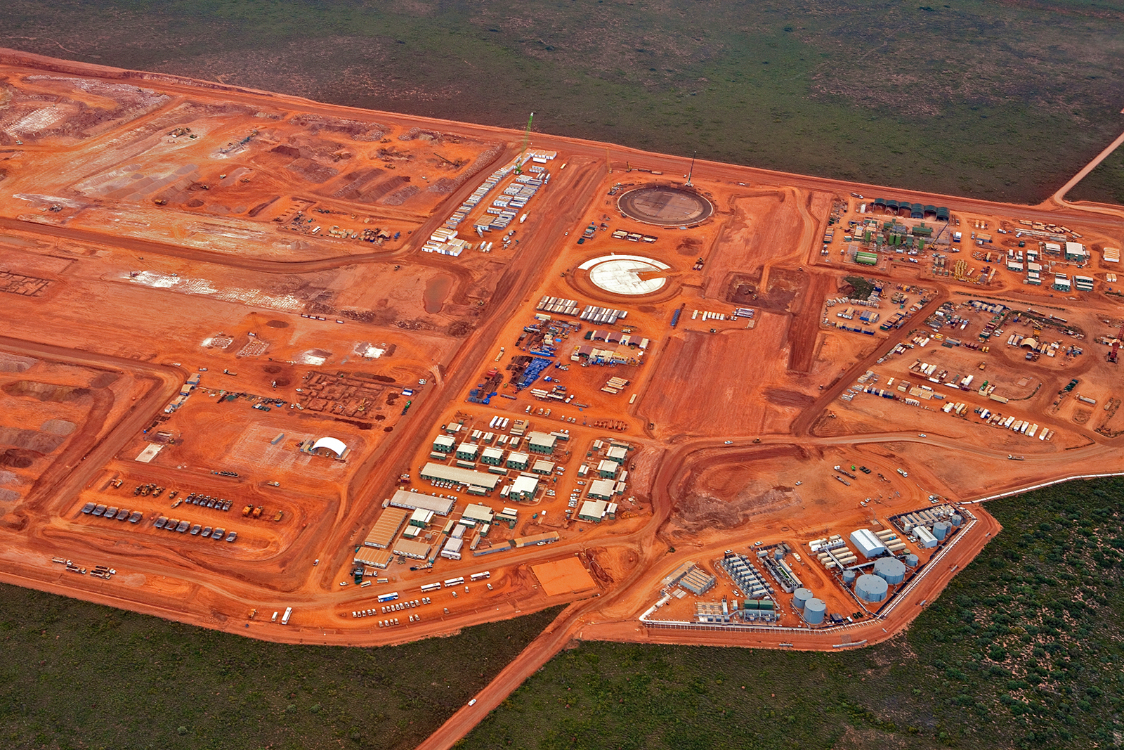 Figure 6. Chevron Gorgon LNG plant
under
construction on Barrow Island (Chevron).
Without any doubt the jewel in the crown of the North-Western economy is however the gas and oil industry. The first major oilfield in the North-West was opened on Barrow Island, near Karratha, and peaked in production output during the 1970s, yielding mainly light crude oil and some gas. During the early 1980s, Woodside Petroleum developed the North Rankin A gasfield, using an offshore platform, seabed pipeline and large LNG production facility on the Burrup Peninsula, north of Karratha. It was followed in 1995 by the Goodwyn A platform, which routes its production output to the North Rankin A platform, and then to Karratha. WA Petroleum (WAPET), later subsumed by its parent Chevron, is now developing the Gorgon gasfield, with a major LNG facility under construction on Barrow Island. It is being followed by the Chevron Wheatstone project, which will ship gas from a platform northwest of Barrow Island to an LNG plant under construction near Onslow. 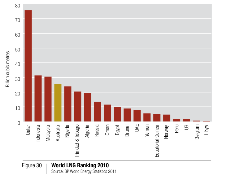 Figure 7. (via Department of Mines and Petroleum, Government of Western Australia) Current planned production rates for these facilities are of the order of 50 million tonnes of LNG annually, with Wheatstone alone having expansion potential to 25 million tonnes annually. These production rates are well in excess of Malaysian and Indonesian LNG production, and will rival the production rate of Qatar, at this time the leading global LNG exporter. Figure 8. Rendering of Chevron
Wheatstone LNG
plant under construction at Onslow on the Pilbara coast (Chevron).
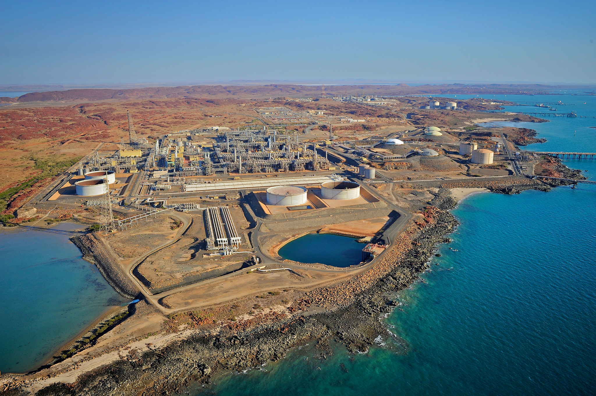 Figure 9. Woodside
Burrup Peninsula plant (Woodside Petroleum).
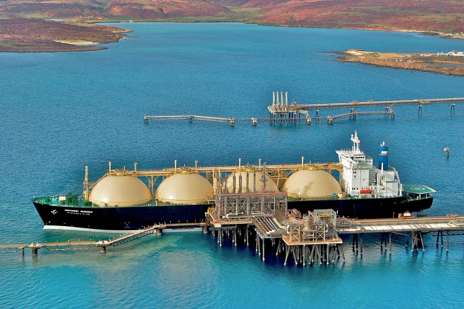 Figure 10. LNG tanker
at the Woodside loading facility near Karratha
(Woodside Petroleum).
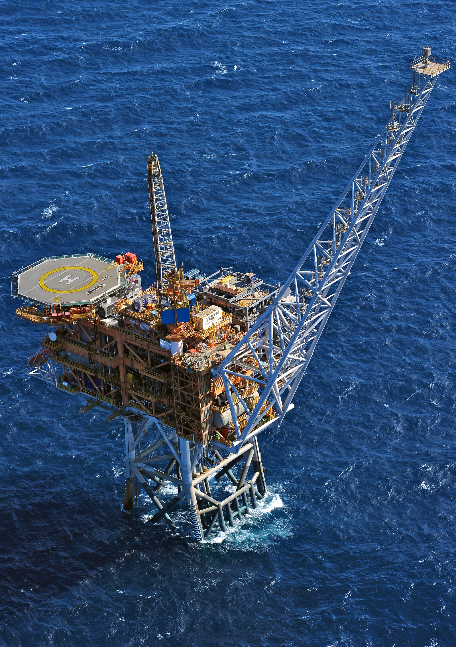 Figure 11. Woodside Pluto
production
platform (Woodside Petroleum).
The North-West Shelf gas and oil industry is a major national export revenue earner, and enables a range of other industries, such as ammonia production and alumina refining. A substantial proportion of Western Australia's electricity, used by industry and residential consumers, is generated from North-West Shelf gas. The gas and oil industry are of enormous strategic value, but also present direct and indirect strategic vulnerabilities. An opponent intending to damage Australia's economy, or the economy of any nation heavily dependent upon imports from Australia, could produce significant effect by stopping LNG and condensate exports, an effect exacerbated by the flow-on effect of other industries in Western Australia which depend on gas supply to operate. Closing down North-West Shelf gas production closes down alumina production, and gas supply to manufacturing and residential users in Perth. Lesser but still significant damage could be inflicted by threatening or interdicting SLOCs, thus preventing export product from the mining and gas/oil industries from reaching its destinations, mostly in Asia. In strategic terms Australia is thus presented with a confluence of growing strategic exposure due to the increase in the economic importance of the North-West, while increasing strategic competition over the Indian Ocean and its critical SLOCs increases the strategic importance of the North-West for siting military basing infrastructure, especially airfields. It is critical to observe that the LNG infrastructure in the North-West Shelf region is highly vulnerable to attack using Precision Guided Munitions, which have proliferated widely across Asia over the last two decades. LNG storage tanks, when full or near full, store energy comparable to that in a tactical or strategic nuclear warhead, albeit not released as quickly. Nevertheless, an armour piercing, concrete piercing or shaped charge cruise missile warhead could easily penetrate the shell of such a tank and cause an uncontrollable fire. Other infrastructure, such as offshore platforms, LNG trains, condensate scrubbing and storage facilities, and LPG plant, is also vulnerable. A major concern historically, with uncontrolled fires in such facilities is the BLEVE (Boiling Liquid Expanding Vapour Explosion) which is not unlike a Fuel Air Explosive (FAE) bomb in effect, levelling buildings and tearing apart infrastructure, while causing flash burns and fires. This can significantly increase the damage footprint of a fire in a petrochemical facility. The radar contrast of these large facilities, constructed with steel and concrete, is sufficiently good that pilots used same as navigation references even thirty years ago. The regional proliferation of modern submarines, armed with ASCMs, and often LACMs, means that any nation with the motive could inflict significant damage upon the North-West Shelf infrastructure with one or two SSK sorties. Moreover, if the perpetrators did not admit the attack, they could be very difficult to identify. More overt, but no less difficult to defeat would be modern aircraft armed with ASCMs or LACMs. Later models of the Sukhoi Flanker flown from any number of sites in the Indonesian archipelago have the reach to hit these targets. LRMP aircraft and tanker supported bombers could also strike from the Asian continent [15][16]. China's intended deployment of multiple aircraft carriers adds an additional consideration to this problem. While the intended air wing composition of these vessels is yet to be seen, and thus their intended role is yet to be understood, changes in the composition of such an air wing to provide a robust force projection capability could be effected in a small number of years. At this time the yet to be understood role of China's carrier battle groups adds considerable uncertainty to the strategic equation in the short, medium and long term. More than often any mention of such vulnerabilities in the Australian defence debate typically elicits arguments about the motives and agendas of regional nations, inevitably concluding that India, China, Indonesia and other nations have no immediate motive to attack, and therefore the vulnerability should be ignored. Unfortunately, the reality of past conflicts is that neutral nations and non-participants have been attacked for any number of reasons. War materiel, such as energy products, minerals and metals, have been “fair game” on the high seas, in times of war, regardless of the flag flown. it is unfortunate that in times of conflict, neutrality is not an effective defence, and motives for attacks range from strategic necessity, through intimidation, to simple spite. The unavoidable conclusion is that Australia will need to develop the capability to deny other nations opportunities to launch attacks upon the Western Australian economic infrastructure, and opportunities to interfere with shipping of resource industry products from Western Australia. |
||||||||||||||||||||
Australia's Indian Ocean Offshore Territories |
||||||||||||||||||||
| Australia's two
Indian Ocean offshore territories, the Cocos (Keeling) Islands and
Christmas Island are both valuable strategic assets. Neither island territory has been a major feature of the ongoing defence policy debate, or in recent media focus, until Christmas Island became home to an immigration detention facility, and public statements were recently made about increased Defence use of the Cocos (Keeling) Islands. Discovered in 1609, the Cocos (Keeling) Islands were initially a privately owned asset, granted to the Clunies-Ross family in perpetuity by Britain in 1886, with jurisdiction transferred to Australia in 1955, and the Clunies-Ross family losing control of the islands by the late 1970s. The economy was since initial colonisation based on palm tree plantations, but more recently eco-tourism, especially for divers, has become prominent. The Cocos (Keeling) Islands are in geological terms a horseshoe shaped coral atoll situated on top of an extinct volcanic seamount, itself part of a submerged mountain range. The central lagoon is very shallow, and unusable for warships without deep dredging. Like other similar atolls, Diego Garcia in the British Indian Ocean Territories being a good example, average elevation above sea level is very low, and usable surface area both limited, and broken into multiple islands and islets. The largest two islands surrounding the atoll, both inhabited, are the West Island or Brown's West Island, and Home Island in the north-east of the atoll. The total land area of the atoll is only 14 square kilometres, almost exactly half the land area of Diego Garcia, and much is covered with a former but no longer maintained commercial palm tree plantation. The local environment is typical of tropical coral atolls in the Indian and Pacific Oceans, and is home to a wide variety of marine flora and fauna. 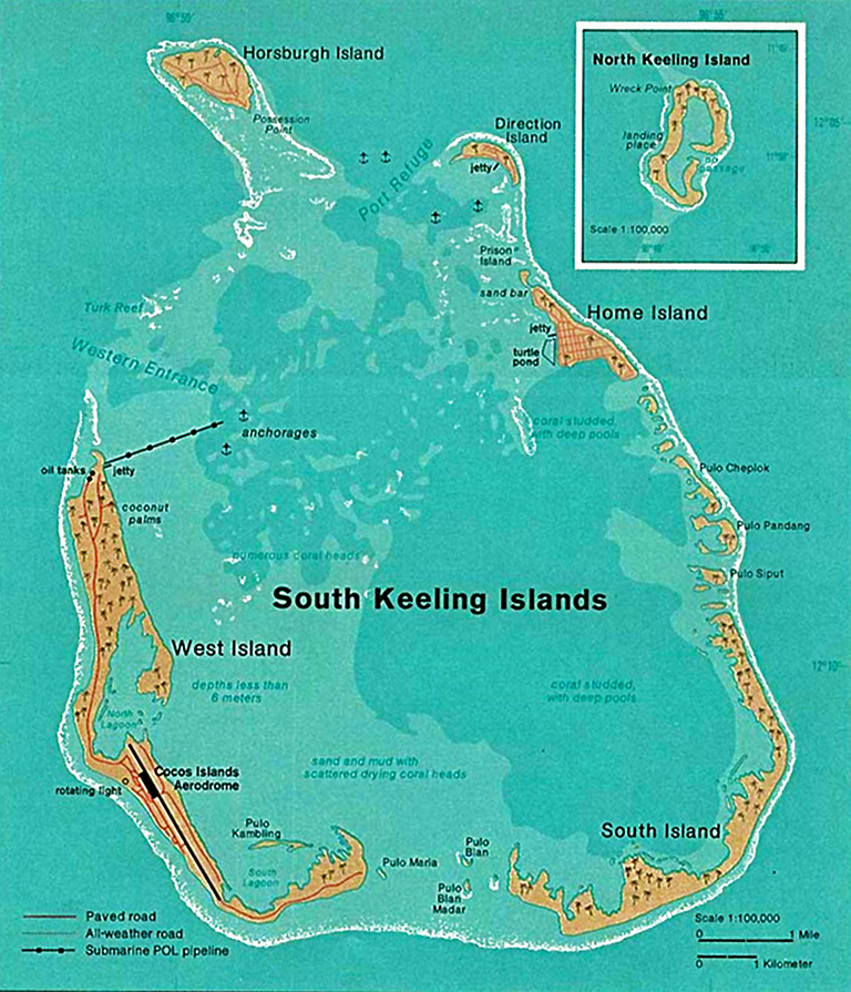 Figure 12. Map of the Cocos
(Keeling) Islands (Central
Intelligence
Agency).
Christmas Island was discovered in 1643, and settled by the Clunies-Ross family in the late 1880s, at which time they established a phosphate mine. The island was transferred from British to Australian jurisdiction in 1957 – 1958, with Singapore being paid compensation for lost earnings through phosphate mining. The Christmas Island economy was dominated by phosphate mining until 1987, upon which most revenue was produced by a casino resort operated between 1993 and 1998. The resort is now active again as a tourist destination. Christmas Island has been repeatedly the focus of media attention, initially over casino operations, then the MV Tampa asylum seeker controversy, and most recently, the immigration detention facility established at a cost of AU$400 million, with a AU$30 million annual running cost, according to Amnesty International. 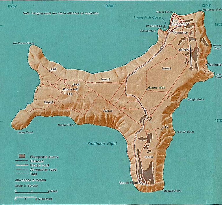 Figure 13. Map of the Christmas
Island (Central Intelligence
Agency)
Unlike the Cocos (Keeling) Islands, Christmas Island is a substantial volcanic island with a total land area of 135 square kilometres, of which much is elevated 200 to 300 metres above sea level, with steep cliffs along much of the coastline. The Geoscience Australia summary states: “The island is the summit of a submarine mountain, which rises steeply from sea level to a central plateau. The plateau reaches heights of up to 361 metres and consists mainly of limestone and layers of volcanic rock. Surrounding the island is a narrow tropical reef which plunges steeply to the ocean floor. Within 20 metres of the shoreline, you can find some of the steepest drop-offs in the world reaching a depth of about 500 metres within about 200 metres beyond the edge of the reef.” Much of Christmas Island is covered with rainforest, and the long term geographical isolation has led to the evolution of a wide range of endemic species of plant and wildlife, including a number of endangered species. The island's ecology is in considerable difficulty, detailed further. In geological terms Christmas Island is similar to Guam, but about one quarter of the size of the latter. |
||||||||||||||||||||
The Pilbara and Kimberley during the Second World War |
||||||||||||||||||||
| In geostrategic
terms, Western Australia provides the ADF or an ally such as the United
States, a major advantage in providing secure land accessible basing
locations capable of covering the eastern Indian Ocean
chokepoints in the Indonesian archipelago, and South-East Asia.
Moreover, Christmas Island
and the Cocos (Keeling) Islands provide valuable Forward Operating Base
(FOB)
locations for LRMP/ASW/ASuW aircraft, submarines and strike aircraft,
as well as diversion runways for
long range maritime strike operations deep into the Indian Ocean. During the Second World War, a chain of airfields constructed across the Pilbara and Kimberley regions were used for exactly this purpose, including major airfields at RAAF Learmonth (Potshot) and RAAF Corunna Downs in the Pilbara, and RAAF Truscott in the Kimberley. 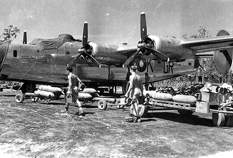 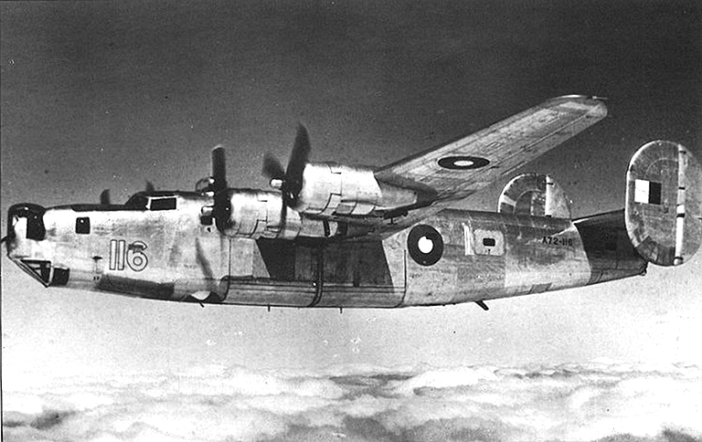 Figure 15. Consolidated B-24L-CO-10 A72-116 of 7 OTU RAAF based at Tocumwal, NSW. 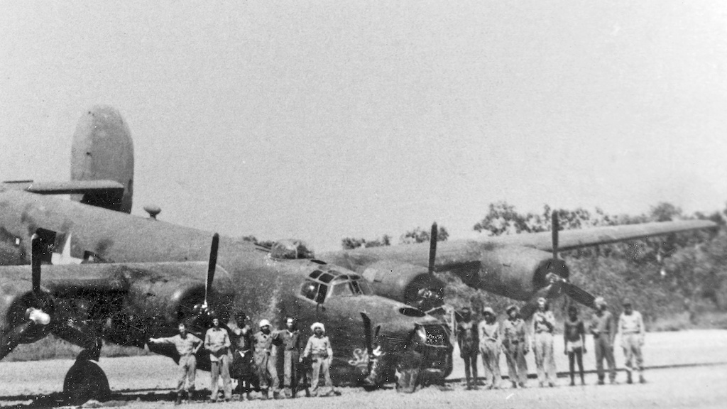 Figure 16. Consolidated
B-24D-53-CO Liberator
S/N 42-40369 “Shady Lady” of 528th BS, 380th BG,
stranded on a salt pan
on the Anjo Peninsula in August, 1943. Until RAAF B-24 squadrons
reached full strength, the 380th BG was the mainstay of the deep strike
effort in the theatre. The depicted aircraft is unusual for two
reasons. The first is that it was an in theatre modified B-24D with a
Consolidated A6A nose turret retrofitted in
Townsville, and the ventral ball turret replaced with a pair of .50 cal
guns. The second reason is the circumstance
of the photograph. This aircraft was flown as part of an unescorted 12
aircraft long range strike from Fenton in the Northern Territory,
against the critical POL refinery and harbour in Balikpapan, Borneo, on
the 13th August, 1943. These sixteen hour duration raids involved low
altitude bombing and strafing of targets, at ranges similar to the well
known Ploesti raids flown from North Africa. With fuel depleted, “Shady
Lady” attempted a landing on a salt pan, but the soft surface caused
the nosewheel to collapse. The crew were rescued by local Aboriginal
people and Benedictine monks from the Drysdale mission, who later
assisted with moving repair crews and components to the site, so the
aircraft could be repaired and flown out [17] (US Air Force).
RAAF and US Army Air Corps aircraft, including B-24 Liberator heavy bombers, attacked coastal targets and Japanese shipping across the region from these bases, with RAAF Truscott and Corunna Downs used as Strategic Forward Operating Bases (SFOB). RAAF Truscott, still in use for commercial operations as Mungalalu Truscott Airbase, was built on the Anjo Peninsula in 1944 to replace the inadequate airfield at Drysdale station. It was used as a staging base for long range B-24 raids against targets in Java and Borneo, as well as ASW patrols, and RAAF Spitfire LF.VIII fighter squadrons rotated through the base to provide defensive cover. RAAF Corunna Downs, abandoned since the 1940s, was built as Strategic Forward Operating Base for B-24 strikes into Java and Sumatra. Located near Marble Bar, it was the largest bomber base in Western Australia. The primary strike force available between early 1943 and early 1945 was the USAAC 380th Bomb Group, comprising the 528th, 529th, 530th, and 531st Bombardment Squadrons, all under RAAF operational control. The 380th was supplanted upon its departure to the Philippines in early 1945, by 12SQN, 21SQN, 23SQN, 24SQN, 25SQN, 99SQN and 102SQN RAAF equipped with B-24J/L/M Liberators. Corunna Downs and Truscott were frequently used to stage 380th BG B-24s based at Darwin, and later 25 SQN B-24s based at RAAF Cunderdin, and 23 SQN, 24 SQN B-24s based in the Northern Territory [18]. Onslow, located between Exmouth and Karratha, and currently planned to become a major LNG processing site, was the location of a major naval fuel oil and aviation fuel depot, which supported Learmonth/Potshot and Corunna Downs [19]. RAAF Learmonth was constructed initially as a fighter base to protect the US Navy submarine replenishment facility at Exmouth, designated Potshot, but also hosted bomber deployments. Exmouth is now home to the Harold E. Holt Naval Communication Station which provides VLF relay capability, and RAAF Learmonth was redeveloped into the current RAAF bare base.
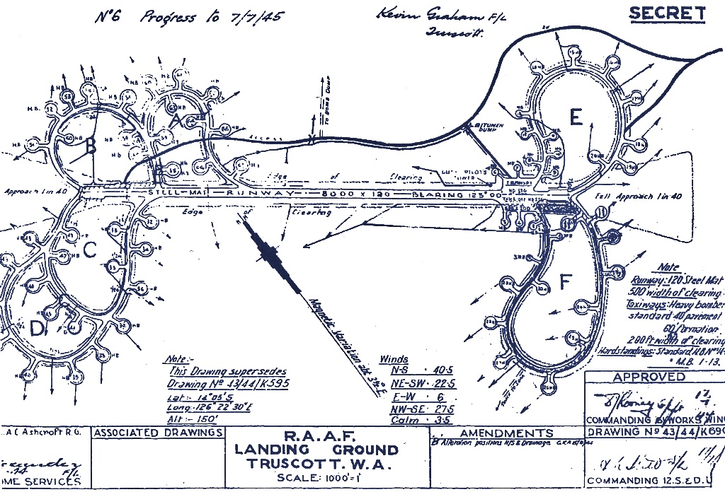 Figure 18. RAAF Truscott (RAAF).
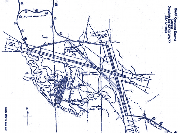 Figure 19. RAAF Corunna Downs
[North aligned] period map (RAAF).
 Figure 20. Pelican Point at Crawley on the Swan River was the site of a Catalina seaplane base, used by Qantas and US Navy PBY squadrons VS-6, VP-11, VP-21, VP-22, VP-33, VP-34, VP-52, VP-101 and VP-102. The ferry is turning into what used to be a takeoff run area for the PBYs (© 2011 Carlo Kopp). 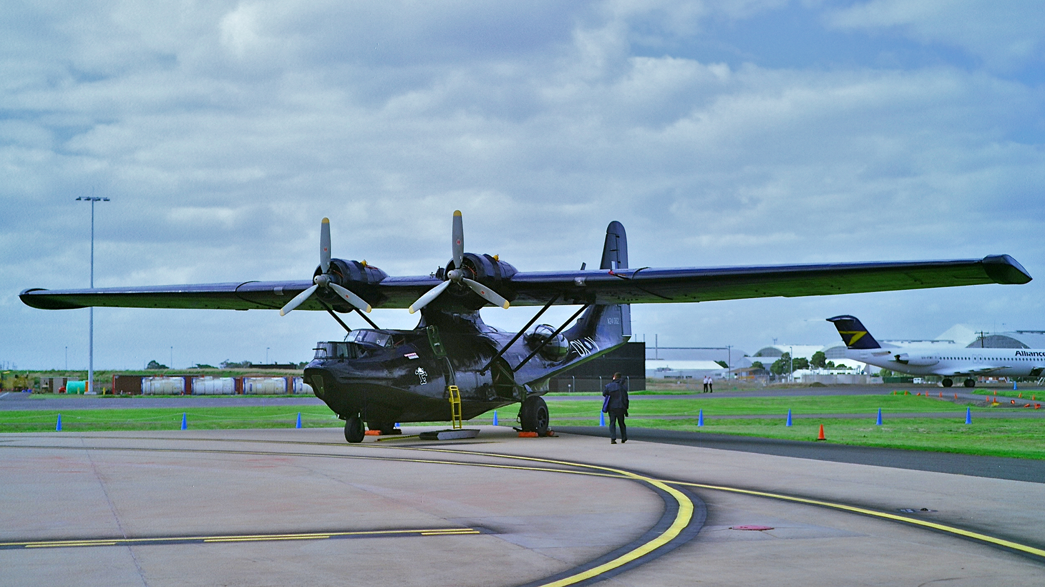 Figure 21. The Consolidated PBY Catalina played an important role during the Second War War, used for ASW patrols, maritime reconnaissance, minelaying, combat search and rescue, and the insertion and extraction of special forces units. The depicted HARS PBY-6A is painted to represent RAAF 43 SQN A24-362 OX-V used for combat search and rescue and minelaying, based in the Northern Territory (© 2011 Carlo Kopp). Fremantle became a major logistical hub, and staging port for naval units. Perth hosted numerous training and logistical units, and a base for Catalinas carrying mail and passengers across the Indian Ocean, at Crawley on the Swan River, adjacent to the University of Western Australia campus. Less known is that a number of US Navy maritime patrol squadrons equipped with PBYs rotated through the Crawley base, providing ASW coverage of the Fremantle / Perth area. The primary military airfield in close proximity to Perth was RAAF Cunderdin, which hosted RAAF “City of Perth” 25 SQN B-24L/M Liberators, P-40 Kittyhawks, and some USAAC B-24s tasked with LRMP/ASW duties. A major airfield was constructed for USAAC operations at Middle Swan late in the war, now Caversham, but it did not see significant use, the associated satellite runways have mostly since been overbuilt through suburban growth. 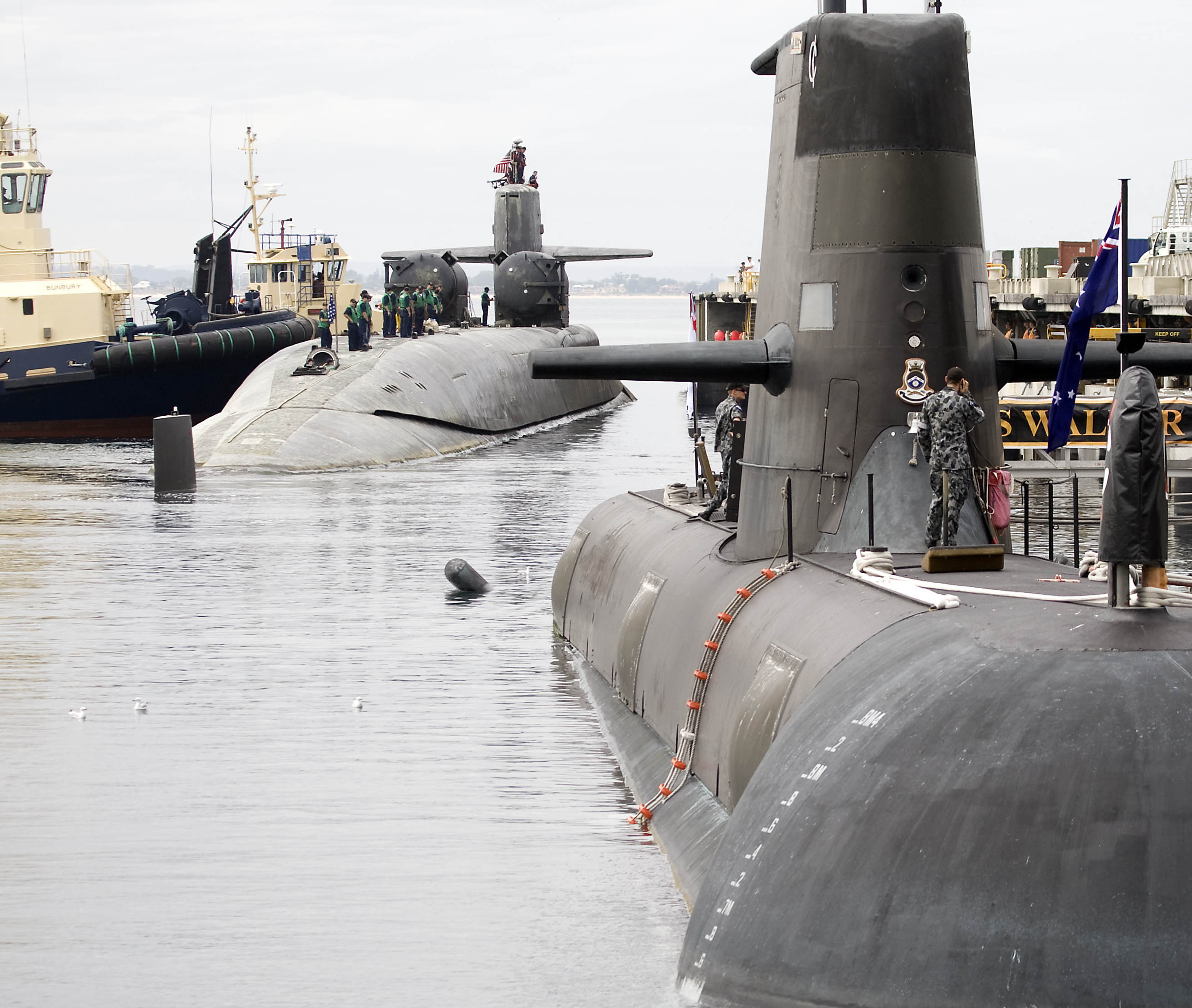 Figure 22. Fleet Base West - HMAS
Stirling at Garden Island. In the foreground, HMAS Waller, in the
background, SSGN-726 USS Ohio (U.S. Navy).
|
||||||||||||||||||||
Australia's Indian Ocean Offshore Territories during the Second World War |
||||||||||||||||||||
| Australia has
made little use of the strategic position of either Indian Ocean
offshore territory since it gained control of them a half century ago.
The Cocos (Keeling) Islands have been employed on a regular basis as a
Forward Operating
Base (FOB) for refuelling P-3 Orion Long Range Maritime Patrol (LRMP)
aircraft, especially during the late Cold War period when Soviet fleet
movements needed to be closely monitored. During the Second World War both Indian Ocean offshore territories were deemed important enough for military use. Christmas Island was invaded and occupied by the Japanese in March 1942, following several raids by Japanese submarines, surface warships and naval aircraft. The British garrison collapsed when the Indian troops stationed on the island mutinied and then killed the five British military personnel on the island. A very small garrison of Japanese troops held the island until October, 1945, when the Royal Navy arrived and British forces secured the island. The Cocos (Keeling) Islands were intended to play a much larger role in Commonwealth military operations conducted by South East Asia Command (SEAC) during the Second World War. Operation Zipper was a planned joint force invasion of South East Asia by the Commonwealth XIVth Army, to retake Malaya and Singapore, occupied by the Japanese in 1941. The Cocos (Keeling) Islands were identified as the most suitable location for a Strategic Forward Operating Base (SFOB), from which the Royal Air Force could perform sea control using LRMP aircraft, and launch strategic bombing raids using heavy bombers. In 1944 logistical and construction units of the XIVth Army landed on the islands and commenced clearing of West Island and the construction of the airfield. This effort was designated Operation Pharos [20]. Royal Air Force Supermarine Spitfire LF.VIII aircraft were shipped by sea to the airfield, borken down in crates, and reassembled at the airfield. The Royal Air Force 136 SQN, previously distinguished in operations flown over Burma, was redeployed from India in April, 1945, to operate the newly delivered Spitfires. The Spitfires were to provide air defence and escort capabilities. Royal Air Force 136 SQN was operationally ready in June, 1945. DeHavilland Mosquito PR.XXXIV long range photoreconnaissance aircraft of 684 SQN, based in India, deployed to the Cocos (Keeling) Islands once the Spitfire unit was ready. The Mosquito PR.XXXIV employed an additional bomb bay fuel tank to provide sufficient operating radius to perform pre-strike photoreconnaissance over Malaya, and bomb damage assessment. With the Cocos (Keeling) Islands established as a secure operational base, SEAC redeployed two Royal Air Force heavy bomber squadrons from India, 231 Group's 99 SQN and 356 SQN, in July, 1945. Both units were equipped with Liberator B.VI (B-24H) bombers. The intended full deployment of 231 Bomber Group did not eventuate due to the collapse of Japan, with the remaining squadrons still located at bases in India. Due to the persistent risk of German U-boats and Japanese submarines, and the ongoing effort to interdict Japanese surface traffic in the Indonesian archipelago, SEAC deployed detachments from 160 SQN, 203 SQN and 321 (Netherlands) SQN, in 222 Group, for LRMP tasks, from their bases in Ceylon (Sri Lanka). The latter were equipped with Liberator GR.VI (B-24G/H/J) and GR.VIII (B-24J) aircraft. The Royal Air Force Liberators were highly active in the last weeks of the war, attacking Japanese shipping targets in Java, and bombing and strafing the Japanese airfields at Benkeolen in Sumatra, also credited as the last Royal Air Force strike sortie of the war. Less known is that the Liberators performed covert supply drops for special forces operating in Malaya. A major strike on Singapore was cancelled as Japan's surrender became known. Thereafter the Liberators were used to drop supplies to Allied POWs, and later used as makeshift transports for evacuations of Allied POWs. A 203 SQN GR.VI was lost to Japanese fighters on the 14th August, 1945, near Rakata Island in the Sunda Strait [21]. With the collapse of Japan following the B-29 nuclear attacks, the Cocos (Keeling) Islands SFOB never attained its intended operational tempo or intended role as the primary bomber base for the defunct Operation Zipper. The RAF airfield was redeveloped into the existing West Island field. |
||||||||||||||||||||
Strategic Considerations for Indian Ocean Basing Infrastructure |
||||||||||||||||||||
| Historically,
Australia's fundamental strategy was constructed around the concept of
denying the use of the sea-gap to potential opponents in Asia,
reflecting the experience of the Second World War, where Japanese
access to basing in what is now Indonesia permitted Japanese aircraft
to attack targets across northern Australia. Until recently, Australia
had a robust capability to implement this strategy, using submarines,
but especially F/RF-111C aircraft armed with AGM-84 Harpoon
anti-shipping
missiles, and Paveway guided bombs. The evolving strategic environment requires a fundamentally stronger strategy, as at this time the Australian continent is within the reach of a number of weapon systems which are not reliant upon basing in Indonesia to achieve strategic effect. In 2008, Kopp et al proposed a revised strategy, labelled “regional denial” [22]: “In strategic terms this means that Australia should centre its future military strategy on “regional denial” with the aim of denying operations in the sea-air gap, above and around the Australian continent, and also denying the basing of combat forces and facilities in the northern archipelago. To implement such a strategy, Australia will need to fundamentally rethink its approach to air power, naval power and land force capabilities. Current and future capabilities for the RAAF will need to be focussed in two key areas. One is persistent air dominance and the related capability to kill cruise missiles and their launch platforms. The second is in providing long range strike capabilities with sufficient weight of fire to render regional basing unusable in combat. Maritime patrol and Anti-Submarine Warfare capabilities need a complementary focus and will also require growth. Current and future capabilities for the RAN will also need to be focussed in two key areas. The first is in Anti-Submarine Warfare, requiring surface combatants and submarines which are suitable for this task and sufficiently numerous. The second capability is in providing organic cruise missile defences for surface warships and escorted shipping. Current and future capabilities for the Army will need to include Surface to Air Missile, and in the future Directed Energy Weapon, defences against cruise missiles, ballistic missiles and other guided weapons, to protect critical military and industrial infrastructure, and population centres. The Army will also need to assume responsibility for protecting such targets against Special Forces attack. Another important future role for the Army is providing covert insertion and extraction means for Infantry and Special Forces operating across the region. Sufficient capabilities should be available to deploy, sustain and extract useful numbers of Infantry and Special Forces troops.” Implementing this strategy requires both suitable force structure investments, but also suitable basing infrastructure to support the types of platforms and required sortie rates. Provision of Anti-Submarine Warfare and long range strike capabilities are the most challenging, the former due to range and persistence requirements, the latter due to range and the need to penetrate modern air defences [23]. The heavy use of Northern and North-Western Australian bases through the Second World War, by the RAAF, USAAC and US Navy, reflects the advantageous geographical placement of these sites relative to areas which are geographically of strategic interest in South East Asia. The geostrategic importance of these key areas of South East Asia has increased since the 1940s, but the geography remains unchanged. If the intent is to operate military platforms across these areas, the optimally placed locations in terms of range and coverage are those sites in the Pilbara, Kimberley and Northern Territory which were employed for basing during the 1940s, or proximate locations. This is depicted in Figure 23. No differently, the British 1940s investment in the Cocos (Keeling) Islands is a reflection upon the excellent geographical location, for any operations intended to cover the chokepoints of the Malacca and Sunda Straits, and the major sea lanes skirting Southern India. In this context, the great circle distances (Refer Figure 23) range between 600 nautical miles and 1,500 nautical miles, which is well within the capabilities of LRMP aircraft, tanker supported tactical fighters, and naval surface and subsurface assets. Attempting to cover the same geographical footprint from the Pilbara or Kimberley mostly doubles the required distances, which doubles transit times, doubles fuel burn, and mostly halves achievable sortie rates.  Figure 23 (©
2012 Carlo Kopp).
This is true for aircraft, but is an even greater challenge for naval assets, be they surface fleet or submarines, as their transit speeds are less than 10 percent the transit speeds of aircraft. Fuel aside, replenishment of expended munitions is a major issue, especially for the Navy. While the Navy has the option of underway replenishment from logistical ships, these must be escorted in and out of contested waters, and protected from aerial, surface warship and submarine attack during replenishment. This is not feasible if within the reach of hostile land based strike aircraft, without unusually heavy commitment of protective land based Combat Air Patrols and tankers. 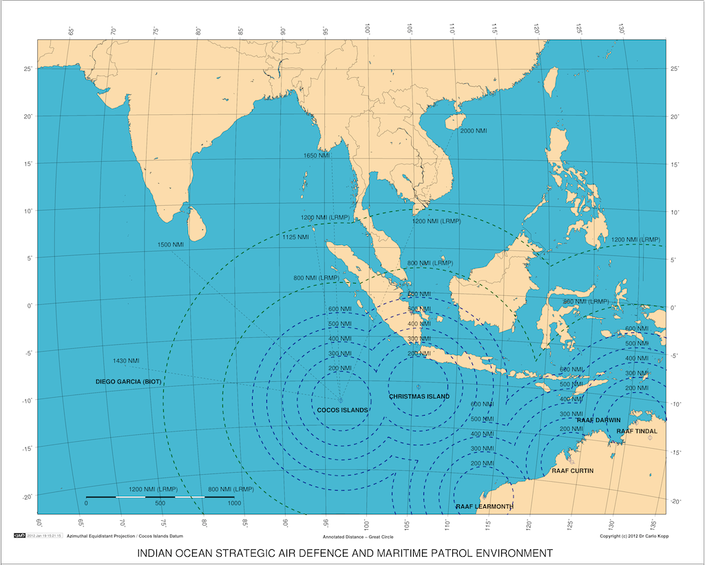 Figures 24 and 25. Wide area and regional maps of Australia's strategic air defence environment in the Indian Ocean region. Blue contours denote combat radius envelopes centred on airfields, red contours denote JORN coverage for the three radar systems at Laverton, WA, Alice Springs, NT and Longreach, QLD (C. Kopp). 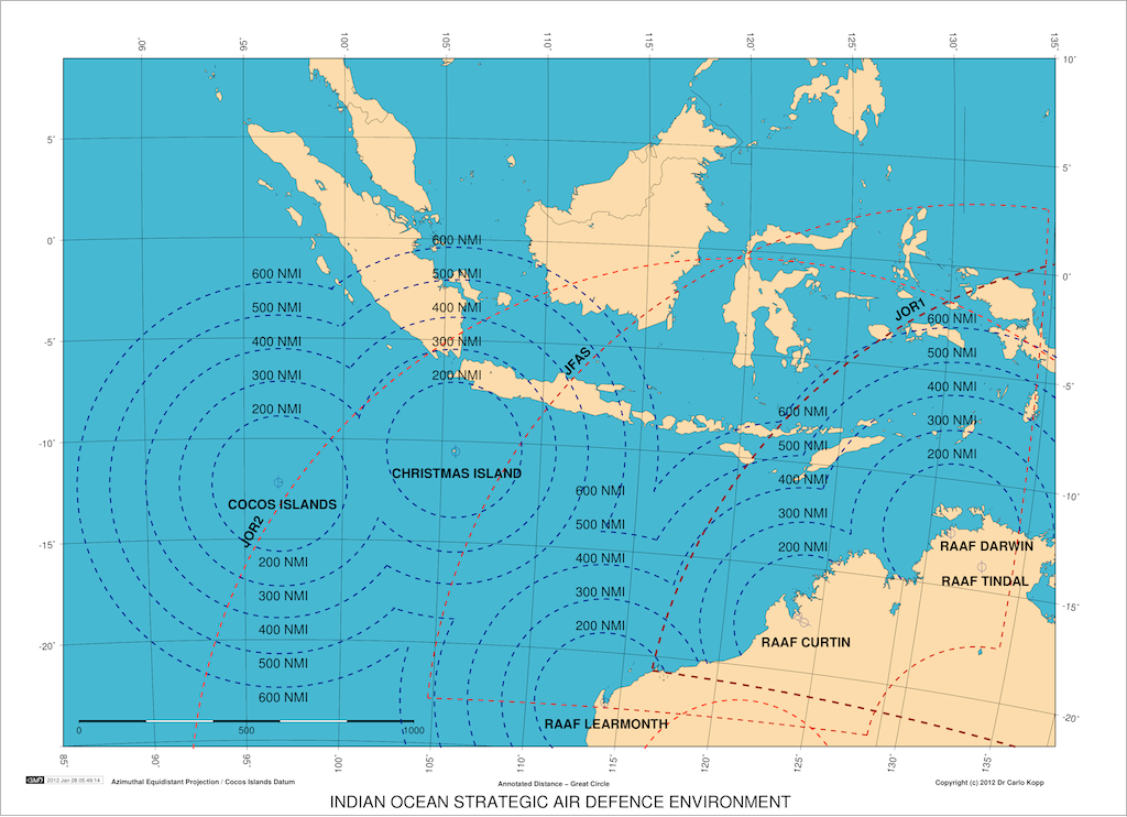 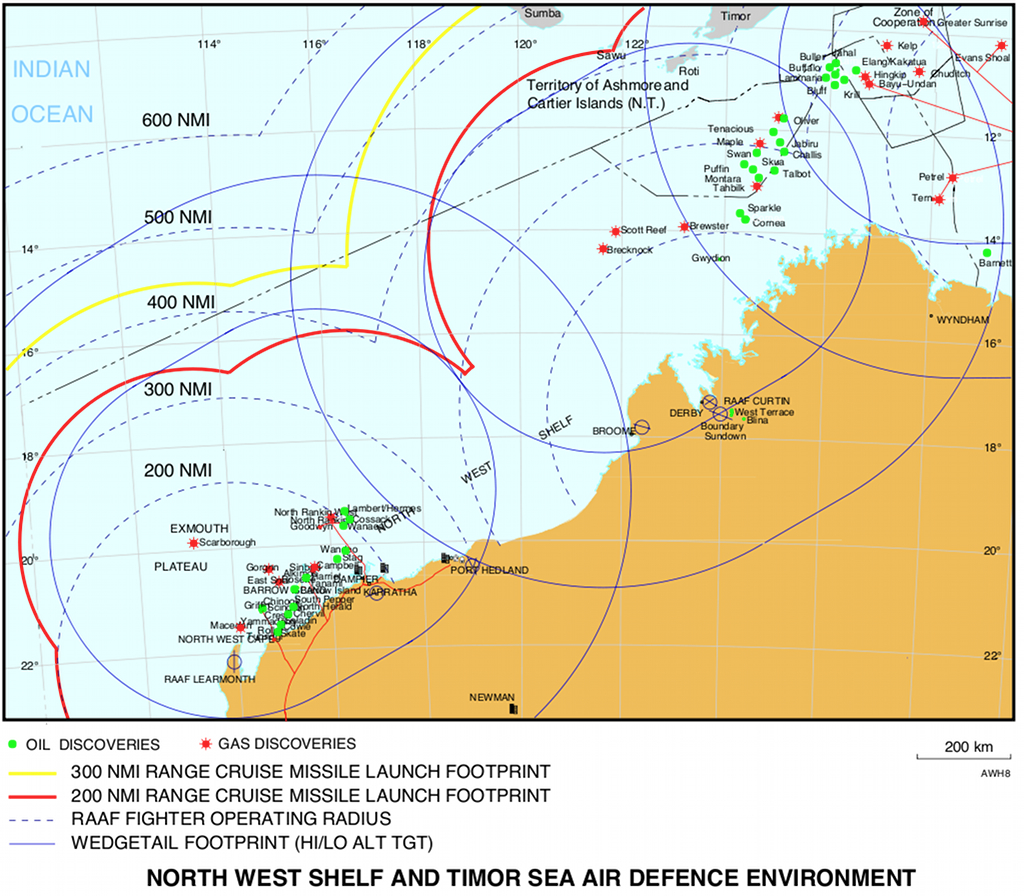 Figure 26 (©
2012 Carlo Kopp).
Basing sites located in the Pilbara, Kimberley, but especially the Cocos (Keeling) Islands represent valuable assets under such conditions, as they can be used to replenish submarines and surface warships with munitions and fuel, and if needed, crew. Moreover, these bases significantly increase available time on station during LRMP sorties. Considering operations deeper into the region, the Cocos (Keeling) Islands also dramatically reduce the demand for tanker aircraft, where tactical fighters need to be deployed. The old adage about “unsinkable aircraft carriers” applies, with the added capability for high volume logistical resupply. If Australia intends to protect its outer Western maritime approaches, and perform both maritime denial and sea control operations in the Indian Ocean, then the Cocos (Keeling) Islands are ideally located. Moreover, the location offers the potential for air strikes into South East Asia, Burma, and the South China Sea, with sufficient tanker support. While the latter may appear “valueless” in the current peacetime regional environment, any major shifts in the political and military alignment of regional nations away from the US Alliance could change that assumption literally overnight. Therefore, the safest strategy for Australia is to properly develop the military potential of the Cocos (Keeling) Islands, as a naval replenishment site, and an air force “Strategic FOB” along the lines of the SEAC effort in 1944 – 1945. It would demonstrate across the region that Australia has the intent and means to defend its sovereign territories and broader strategic interests in the Indian Ocean. Christmas Island could play a similar role, although it is located within 260 nautical miles of Jakarta, and thus is highly exposed in any military situation where Indonesia is occupied by another power, aligns itself with another power, or actually becomes an adversary in its own right. Contemporary tactical ballistic missiles, ground launched cruise missiles and even the smallest tactical fighters can easily reach Christmas Island from any number of sites in Java. The reciprocal dimension of such proximity is that Christmas Island would easily permit high tempo air operations into Indonesia's heartland, a reality which will not be lost upon the TNI leadership in Jakarta. Any significant development of the military potential of Christmas Island would require some very adept diplomacy, and possibly the offer of training facilities and weapons range access on the island for the TNI-AU. If Indonesia becomes embroiled in a regional conflict to its north, a major basing facility on Christmas Island for ADF and US Air Force assets could be invaluable – the critical political dimension is whether Indonesia wishes to remain aligned with the US and Australia in the long term. These considerations apply to Australian strategic needs in the context of defending Australia's immediate interests in the region, during a period of increased strategic competition across the region. An additional dimension to consider is that of the strategic needs of our principal ally, the United States. The United States had an excellent basing network across the Pacific during the Cold War, including multiple bases in Japan, South Korea, the Philippines, the Marianas and Hawaii, with leased access to Britain's Diego Garcia in the Indian Ocean. Two decades after the Cold War the North Asian bases are demonstrably indefensible against Chinese air assets, cruise missiles and ballistic missiles. The large Subic Bay and Clark bases in the Philippines were closed down at the end of the Cold War [24]. While Diego Garcia and Guam have become central basing “hubs”, the remaining bases are of limited utility due to their exposed locations. A crisis in South East Asia or the eastern Indian Ocean would present major challenges, especially for tactical air and tanker aircraft basing. This would be true of a conflict, as much as a major natural disaster. In the context of supporting United States operations in Asia, well developed air and naval basing infrastructure on the Cocos (Keeling) Islands, Christmas Island, Pilbara and Kimberley would become a valuable capability in its own right, which Australia could offer the use of in a major contingency. These sites would provide a genuine basing capability “gap filler” located between the major bases in Guam and Diego Garcia. Military Operations Other Than WarWhile the primary purpose of military basing is to prevail in military conflicts, or deter such conflicts, especially against nation state opponents, it is not the sole purpose of such installations. Military Operations Other Than War (MOOTW) are also of considerable importance, especially where civil authorities in Australia, or other nations are limited in their capacity or capabilities to deal with particular contingencies.MOOTW potentially span a wide range of contingencies, encompassing domestic and foreign contingencies, and ranging across deterrence, stability operations, disaster relief and any other contingency where military capabilities are employed for other than combat operations. United States joint doctrine states: “MOOTW focus on deterring war, resolving conflict, promoting peace, and supporting civil authorities in response to domestic crises”. Two particular categories of contingency are of importance and of interest in the context of the Pilbara, Kimberley, Cocos (Keeling) Islands and Christmas Island - natural disasters and the broader category of supporting law enforcement and enforcing border controls. The first type of contingency, natural disasters, may arise either within Australian territory, or within the immediate region, and often require high intensity logistical and personnel surge deployments to effect relief and rescue efforts. Within Australia, the most likely natural disasters observed in the “deep north” are the result of cyclones, which can be accompanied by severe flooding, and serious infrastructure, and housing damage, arising due to extremely high wind speeds, intensive rainfall and severe sea surface and coastal surge conditions. The best known example of this class of contingency is Cyclone Tracy, which largely destroyed Darwin in December, 1974, and resulted in the greatest single airlift operation in Australian history, when military and civilian aircraft were employed en masse to move much of the population of Darwin to temporary accommodation in other Australian states [25]. While Tracy was unusual in the statistical sense that it was both a large cyclone, and it hit the single largest population centre in the north of the nation, it will, inevitably, not be the last such event, whether in Australia, or in South Asia or South-East Asia. The largest such disaster was in Bangladesh in 1970, when Cyclone Bhola wrought havoc upon low lying coastal areas, resulting in high initial loss of life, and subsequent further losses due to starvation and disease, following flooding, famine and the propagation of waterborne diseases. The subsequent 1991 Bangladesh cyclone was of similar scale and lethality. Strategically sensitive South-East Asia is especially of concern as a location for large scale natural disasters. While cyclones are by far the best known of the likely contingencies, monsoonal flooding without widescale wind and sea surge damage is also a common occurence in this region, and possibly a more frequent contingency in the future with the coincidental circumstances of anthropogenic deforestation and increasing climatic instability. Deforestion can degrade the capacity of the local environment to absorb large short term rainfall, resulting in turn in catastrophic mudslides and faster rainfall runoff, often in excess of the capacity of natural and manmade drainage mechanisms. Tectonic instability in South-East Asia produces by global standards an unusually high frequency of earthquakes, with coincident tsunamis if the epicentre is located on a seabed, as well as an propensity for high volcanic activity levels. Active volcanoes in the region have produced most media attention due to disruptions in air travel arising from ash clouds, and several instances where widebody aircraft were at serious risk of loss following ash induced damage to engines and windshields. The best example of the latter was British Airways Flight 9 in 1982, which lost power over Indonesia due to ash ingestion. Ash clouds are arguably the least severe of the possible outcomes produced by regional volcanic events. The eruption of Krakatoa in the Sunda Strait, in 1883, produced not only large immediate loss of life due to severe local tremors, pyroclastic clouds, lava flows, tsunamis and ash fall, but also more widespread damage due to ash destroying crops, and weather disruption globally. The large scale eruption of Krakatoa in 535 AD has been implicated in much greater damage, on a global scale, resulting in large scale crop and pasture failures, in turn resulting in large scale population displacements. More recently, the 1991 eruption of Mount Pinatubo in the Philippines resulted in intensive ash fall on Clarke AFB, effectively disabling the base [26]. A major volcanic eruption in the near region has enormous potential for damage effects, both locally, and given population density, elsewhere in the region. The tsunami of 2004 with its epicentre near Aceh in northern Sumatra resulted in massive loss of life, mostly in Indonesia and Thailand. The exemplary rescue, relief and aid operation, under Operation Unified Assistance, in which United States and Australian military forces played a pivotal role, presents a historical case study of the value of military assets in disaster relief. Refer Annex C. MOOTW is not however confined to disaster relief, rescue operations and evacuations, although these are the most visible, largest and often most valuable contributions military capabilities can make. Border control operations, especially piracy, smuggling of people, contraband goods, arms and narcotics, and illegal immigration have been persistent problems at any ocean boundaries between developed nations and the developing world. All are byproducts of weak or underdeveloped law enforcement and border control mechanisms, and present expensive problems for the victim nations in question. Notable recent examples on the global stage include persistent problems with seaborne illegal entries in Europe from Africa, persistent large scale piracy on the high seas near the Horn of Africa, especially involving lawless Somalia, and ongoing problems of piracy and terrorism in South East Asia. The nexus between criminal organisations and terrorist movements, where criminal activities are often used as a funding mechanism for terrorism, is an issue in its own right. Military assets have been used in border control operations where civil authorities have lacked specific capabilities for the task, or where the scale of the problem has exceeded civilian agencies' capabilities. Enhancement of basing in the Pilbara, Kimberley, Cocos (Keeling) Islands and Christmas Island, especially where an airbase and naval replenishment facility, with logistical infrastructure, can be co-located, provides a high value capability for MOOTW, especially for dealing with both domestic and near region natural disasters. Key initial imperatives in natural disasters are damage assessment using ISR systems, rapid delivery of aid supplies and rescue personnel into the disaster area, and rescue and evacuation of disaster victims. Basing of suitable capacity on the mainland can be employed as staging and operational basing for disaster relief forces deployed into the area, and are especially useful for logistical buffering of incoming bulk aid supplies. The capacity to refuel from high volume fuel storage permits high sortie rates for helicopters and airlifters tasked with supply drops and rescue operations. In northern Australia, well hardened military basing with integral water, sewage and electrical generation systems and capacity for accommodating thousands of military personnel, where located in close proximity to population centres, would also present the option of using these sites as sheltered locations for the civilian population during extreme weather events such as cyclones, and as evacuation transit sites following disasters. In border control operations, military basing with robust capacity is valuable for forward basing equipment and personnel, provision of high capacity connections into the C3 network, but also for staging evacuations of detainees. In conclusion, over the long term, the certain need to conduct MOOTW within the “deep north” and near region present compelling reasons why major enhancement of basing in the Pilbara, Kimberley, Cocos (Keeling) Islands and Christmas Island should be pursued. Unlike the conduct of war, where certainty of future outcomes is often in dispute, the need to conduct MOOTW is a well established reality of that geographical area, and the only uncertainties fall into exactly where and when MOOTW will need to be conducted. Strategic Basing
Design Requirements
The Second World War was fought in the South West Pacific Area (SWPA)
using mostly temporary airfields constructed using Perforated Steel
Planking (PSP) and tents for operational work areas and personnel
accommodation, or temporary anchorages. The Cold War, a four and one
half decade
long standoff, saw the introduction and long term use of often well
hardened, permanent basing. The Post Cold War conflicts which
culminated in the invasion of Iraq in 2003 were mostly fought from well
hardened permanent basing infrastructure, built to Cold War period
standards. |
||||||||||||||||||||
Strategic Constraints for Indian Ocean BasingThe relative importance of Australia's bases across the Pilbara, Kimberley, Northern Territory and Indian Ocean Offshore Territories depends in large part on what strategic priorities are assumed, in what type of conflict.During the Second World War, the priority in basing was initially in the Northern Territory and Cape York, to provide support for operations in New Guinea and the Solomons. As the Japanese forces in New Guinea and the Solomons collapsed, the Pilbara and Kimberley gained importance, as the focus of strike operations shifted to Java, Borneo and Malaya. The need to protect, across a wide range of scenarios, the Pilbara oil and gas industry, raises the strategic value of basing infrastructure in the Pilbara. The future development of the offshore Browse and Bonaparte Basins in the Kimberley will see its priority increase in time. These vulnerabilities exist in addition to the Timor Sea oil and gas industry, which raises the priority of Kimberley and Northern Territory basing. If we assume that the principal purpose of basing across the North-West is the defence of the oil, gas and mining industry infrastructure, then equal priority needs to be accorded to all of these geographical areas, in terms of basing air defence fighters, LRMP aircraft, and supporting submarines on ASW patrols. This leads to the conclusion that the extant RAAF Learmonth, Curtin and Tindal bases be upgraded to support sustained operations by RAAF fighters, tankers and future P-8A Poseidon LRMP aircraft or Remotely Piloted Vehicles (RPV/UAV). Such an upgrade strategy is viable, given adequate AEW&C, Tanker and escorting air cover is available, if the strategic posture is reactive, in the sense that an attacker has freedom of choice in choosing the time and place of an attack. Under conditions where the JORN OTH-B system can provide early warning, a fighter CAP, Wedgetail AEW&C and tanker would be launched to effect an intercept. A clever opponent can reverse direction and fly home before the intercept can be effected, resulting in a mission kill against the defending side. This “bait and switch” tactic can be played ad nauseum, literally at the expense of the ADF in aircrew hours, fuel burn and maintenance. An important and very general consideration in the use of air power is that transit time from a base to an area of combat operations is time during which assets are unproductive, yet incurring full operating costs. Operational economics always favours basing at the shortest practical distance. Staying out of the reach of opposing air power and ballistic missiles favours the converse. The “bait and switch” tactic becomes non-viable if RAAF fighters are based on the Cocos (Keeling) Islands and Christmas Island, as the attacker has to contend with the possibility of repeated engagements, as intercepts may be initiated from the island air basing against both inbound and outbound attackers. What the Indian Ocean Offshore Territories offer is depth in the defence of the sea-air gap. An opponent must first overwhelm the bases on the Cocos (Keeling) Islands and Christmas Island before they can even consider attacks against targets in the Pilbara and Kimberley. In effect, military airfields emplaced on the Cocos (Keeling) Islands and Christmas Island extend Australia's defensive depth in the sea-air gap out to well beyond 1,000 nautical miles. This model is predicated on the use of a wholly reactive strategic posture, which may be politically inevitable in any dispute which has yet to escalate into full scale combat operations. There are also clear advantages in the use of airfields in the Cocos (Keeling) Islands and Christmas Island if the strategic intent is denial operations in South East Asia, involving air strikes on shipping and land targets. While such targets are within reach of tanker supported fighters operating from RAAF Learmonth, Curtin and Tindal, sortie rates will be constrained by both distance and cruise speeds. The advantages in the use of airfields in the Cocos (Keeling) Islands and Christmas Island for basing LRMP aircraft are equally pronounced, as time on station increases with decreasing distance to the patrol area. Submarines performing ASW patrols in the Indian Ocean could replenish fuel, expended munitions and swap personnel with minimum loss of availability but using facilities in the Pilbara and the Cocos (Keeling) Islands. In air operations, high sortie ranges involving either long range fighter sorties or long duration fighter sorties, both of which require tanker support, are very demanding in fuel burn, which presents the need for high volume fuel replenishment, especially for tanker aircraft. Consumption for a fighter squadron supported by tankers can run into hundreds of tonnes daily at high operational tempo. The strategy followed in some NATO nations, and some Persian Gulf nations, was to lay POL pipelines between oil refineries located near major ports, and major airbases. This permitted high volume sustained aviation fuel supplies to these bases, enabling in turn intensive operations using tankers [32]. The high volume production of natural gas in the Pilbara and Timor Sea, and future production in the Kimberley, opens up the option of aviation fuel production within the region, using either condensate, or Fischer-Tropsch technology gas-to-liquid (GTL) synthetic crude as feedstock. The main prerequisite for a POL pipeline is that a large LNG plant be located within a reasonable distance of an airfield [33]. Within the immediate future, such plant will be located near Onslow and Karratha in the Pilbara. As the Browse Basin is developed, the Broome/Derby area is likely to acquire an LNG plant. An important benefit of a domestically produced synthetic aviation fuel supply is that it can be sold in peacetime to support domestic civilian and military air operational across Australia, and does not incur the wartime risks associated with imported aviation fuel supplies from refineries in Asia, which could be interdicted or otherwise denied. The alternatives for the ADF are thus replenishment by sea, using tanker vessels, or the provision of synthetic aviation fuel plant and pipelines to carry aviation fuel to bases. While replenishment by sea presents the lowest peacetime infrastructure investment, it also incurs the greatest wartime risks and costs, as shipping is susceptible to air and submarine attacks. Conversely, a synthetic aviation fuel plant in reasonable or close proximity to an airfield falls within the defensive footprint produced by fighters and LRMP aircraft operating from that airfield. The question which then arises is whether it is better to route long pipelines to extant airfields, or construct new airfields in close proximity to established LNG infrastructure? RAAF Learmonth presents an interesting case study. A synthetic aviation fuel plant co-located with the Chevron facility being constructed at Onslow would require a pipeline of 66 to 120 nautical miles of length, depending on whether it is routed across the seabed or on land only. The alternative is the construction of an airfield within 25 nautical miles of Karratha, and locating a synthetic aviation fuel plant on the Burrup Peninsula. While RAAF Learmonth is a dual use airfield, already carrying civilian traffic, its 170 nautical mile distance from Karratha, which is the local population centre, presents pragmatic difficulties in the use of RAAF Learmonth as a “hub” for civilian air traffic into the Pilbara. If we consider benefits other than in military operations, a new airfield constructed close to Karratha would yield a much better return on investment than routing fuel from a synthetic aviation fuel plant to the extant RAAF Learmonth site. What is abundantly clear is that strategic considerations make a exceptionally strong case for the following basing enhancements:
|
||||||||||||||||||||
Basing Development of the Pilbara and Kimberley Regions |
||||||||||||||||||||
| The Pilbara and Kimberley are on
the verge of another major surge in economic growth, with ongoing oil
and gas industry growth, and robust performance in other resource
industry sectors. Increased construction activity required to implement infrastructure to support the energy and mining sectors will inevitably present synergies which should be exploited where possible to reduce the cost and accelerate the timelines of basing facility improvements. A case study of a lost opportunity was the construction of the Darwin to Alice Springs railroad extension. No effort was made to exploit the presence of construction personnel and equipment, and lay down a railway spur to RAAF Tindal to provide low cost replenishment of fuel and movement of materiel into the base. No less importantly, the extant civilian airfield infrastructure in the Pilbara and Kimberley is mostly an artefact of the 1940s, with a number of airfields constructed around the remnants of wartime installations. Both the Pilbara and Kimberley have considerable potential as eco-tourism destinations, but growth in this sector is critically predicated on the availability of airfield infrastructure capable of handling heavy commercial transports, especially the Boeing 747 series and new Airbus A380, which are the backbone of low cost high volume tourist air transport. The only substantial airfield between Darwin and Perth is RAAF Learmonth, which is impractical for high volume tourism due to its location, but also limitations in fuel replenishment capability, essential for long range airliner operations. From a strictly commercial perspective, a major civilian or “dual-use” airfield located in the Pilbara or Kimberley is essential if the potential long term tourism revenues are to be realised. Other synergies exist and should be exploited. The former RAAF Truscott base remains operational as Mungalalu Truscott Airbase, primarily to support offshore gas platforms and local community needs. A runway upgrade compatible with higher gross weight commercial Boeing 737-800 series transports would enable the use of this location as a diversion site for RAAF P-8A Poseidon, Wedgetail AEW&C aircraft, as well as RAAF fighters. An upgrade compatible with commercial Airbus A330-200 would enable the use of this location as a diversion site for RAAF KC-30 tankers, and U.S. Air Force KC-135R and KC-46A tankers. The Anjo Peninsula also has potential as an eco-tourism location, which will not materialise until commercial air traffic can easily access the area. There is no major commercial airfield in close proximity to Broome and Derby, which could be used during future infrastructure development to exploit Browse Basin gasfields. Robust development and upgrading of RAAF Curtin would present the opportunity to make it the “dual-use hub” airfield, permitting heavy airlifter access into the area, and thus cost recovery over time. RAAF Learmonth is within 3 nautical miles of the Cape Range, which runs along the North West Cape, and provides terrain elevations in excess of 200 metres AMSL. This may present opportunities for the construction of superhardened underground hangars, by tunnelling horizontally into hillsides. Tunneling hangars into hillsides is a very effective airbase hardening technique, used extensively by Switzerland, China and the former Yugoslavia. Spoil produced by tunnelling could be exploited during base upgrades. Another synergy which should be exploited is the deployment of the National Broadband Network (NBN) across the Pilbara and Kimberley in coming years. This would present opportunities for secure high bandwidth links into basing infrastructure. |
||||||||||||||||||||
 |
||||||||||||||||||||
Basing Development of the Cocos (Keeling) Islands |
||||||||||||||||||||
| The Cocos
(Keeling) Islands are a coral “horseshoe atoll” very similar in most
key respects
to Diego Garcia in the British Indian Ocean Territories, but much
smaller in available footprint, with a very
shallow lagoon. Therefore, the islands could be developed in a similar
fashion to Diego Garcia, using identical or similar construction
techniques, albeit on a much smaller scale. The Diego Garcia base is a logistical Main Operating Base (MOB) hosting prepositioning ships, POL (Petroleum Oil Lubricant) storage, and an airfield which has been used for heavy bomber strike operations since 1991, but especially during the initial air campaign against the Taliban and Al Qaeda in 2001. The principal limitations of the Cocos (Keeling) Islands when compared to Diego Garcia are threefold:
Diego Garcia presents a good case study for any future development of the Cocos (Keeling) Islands for ADF and potential United States basing in a contingency, with the caveat that the Cocos (Keeling) Islands is not suitable as a logistical MOB, and would be only used as a Strategic Forward Operating Base. While the existing Cocos (Keeling) Islands runway is adequate for the P-3C Orion, it is borderline for fighter operations due to length limitations, and lacks the surface strength for sustained high tempo operations by heavy aircraft, be they civilian transports, heavy military airlifters, or tankers. Survivability in combat dictates dual runways, even if one is only used as a taxiway operationally. The latter, given the need for ~700 ft separation between parallel runways, makes redevelopment of the existing airfield infeasible unless the southern part of West Island is enlarged by landfill into the main lagoon, North Lagoon and South Lagoon. The northern part of West Island, currently a defunct palm plantation, would be viable for dual runway construction, and requires only partial landfill in the Northern Lagoon to provide full runway lengths, refer Figure 27. This would permit use of the legacy airfield as a redundant fighter runway, or storage area. There is sufficient area available for up to 44 Hardened Aircraft Shelters for fighters. Hardened storage for aviation fuel and munition warstocks, and hardened personnel accommodation, would be required, as the Diego Garcia model of moored prepositioning and other logistical ships presents a major vulnerability in wartime. Hardening is essential from both an operational perspective, and to survive seasonal cyclones in situ. 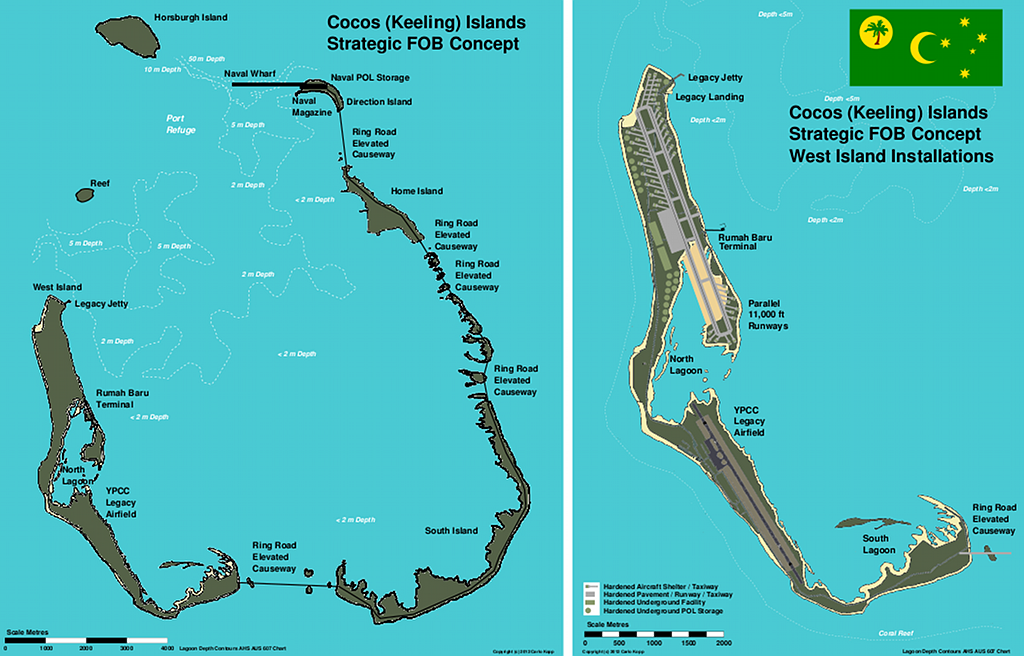 Figure 27. Concept diagram for Cocos (Keeling) Islands redevelopment. This and similar basing arrangements are viable for high tempo combat operations, while providing peacetime eco-tourism potential. Environmental impact is minimised by siting the airfield on the unused coconut plantation, and placing the wharf outside the central lagoon (C. Kopp). A naval replenishment facility with a MIL-HDBK-1025/UFC compliant pier plumbed for POL, and capable of Roll-On Roll-Off transfers of vehicles and materiel, modelled on Diego Garcia although much smaller, is also feasible at Port Refuge, located at the northern tip of Direction Island, where the seamount falls off rapidly, affording deep anchorage and covert submarine access. Covered “submarine sheds” would be preferable to permit covert replenishment. A “ring road” causeway on short pylons would be required to permit road access from the Direction Island wharf to West Island, providing also hardened protection for electrical and optical fibre cables, and POL and water pipelines to a desalination plant. Given that the primary purpose of a naval base on the Cocos (Keeling) Islands would be replenishment of warships and submarines, rather than high volume logistical prepositioning of materiel, demands would be much less challenging than at Diego Garcia. Any limited coral dredging near Port Refuge would need to be performed very carefully given the potential for wider environmental damage to the fragile coral ecosystem in the lagoon, if performed poorly. The latter is not only intrinsically important, given the value of the islands' fragile habitat, but also given the peacetime potential of the islands as a eco-tourism destination. A port capable of berthing cruise ships, and an airfield compatible with long range airliners, provide a critical enabler for eco-tourism, offsetting some infrastructure costs over the longer term. Environmental considerations are discussed below. |
||||||||||||||||||||
 |
||||||||||||||||||||
Basing Development of Christmas Island |
||||||||||||||||||||
| Christmas
Island, given its geological similarity to Guam, presents few problems
in development as a major airbase location. The abundance of dense and tough volcanic rock on the island permits the construction of a well hardened or superhardened airbase facility with no difficulty. The existing Christmas Island airfield site could be readily expanded in the south or south-west direction into a parallel 11,000 ft x 200 ft runway arrangement. The result would be similar to Andersen AFB on Guam, with a runway terminating over a cliff with 900 ft AMSL elevation. 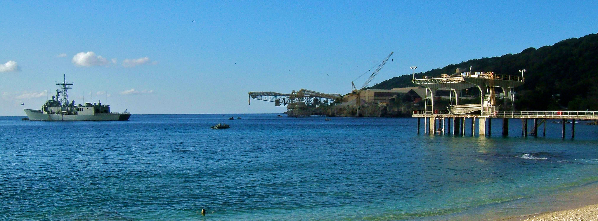 Figure 28. Flying Fish Cove at Christmas Island, with a visiting RAN FFG-7 (© Commonwealth of Australia 2011).  Figure 29. Norris Point
container facility at Christmas Island (© Commonwealth of Australia
2011).
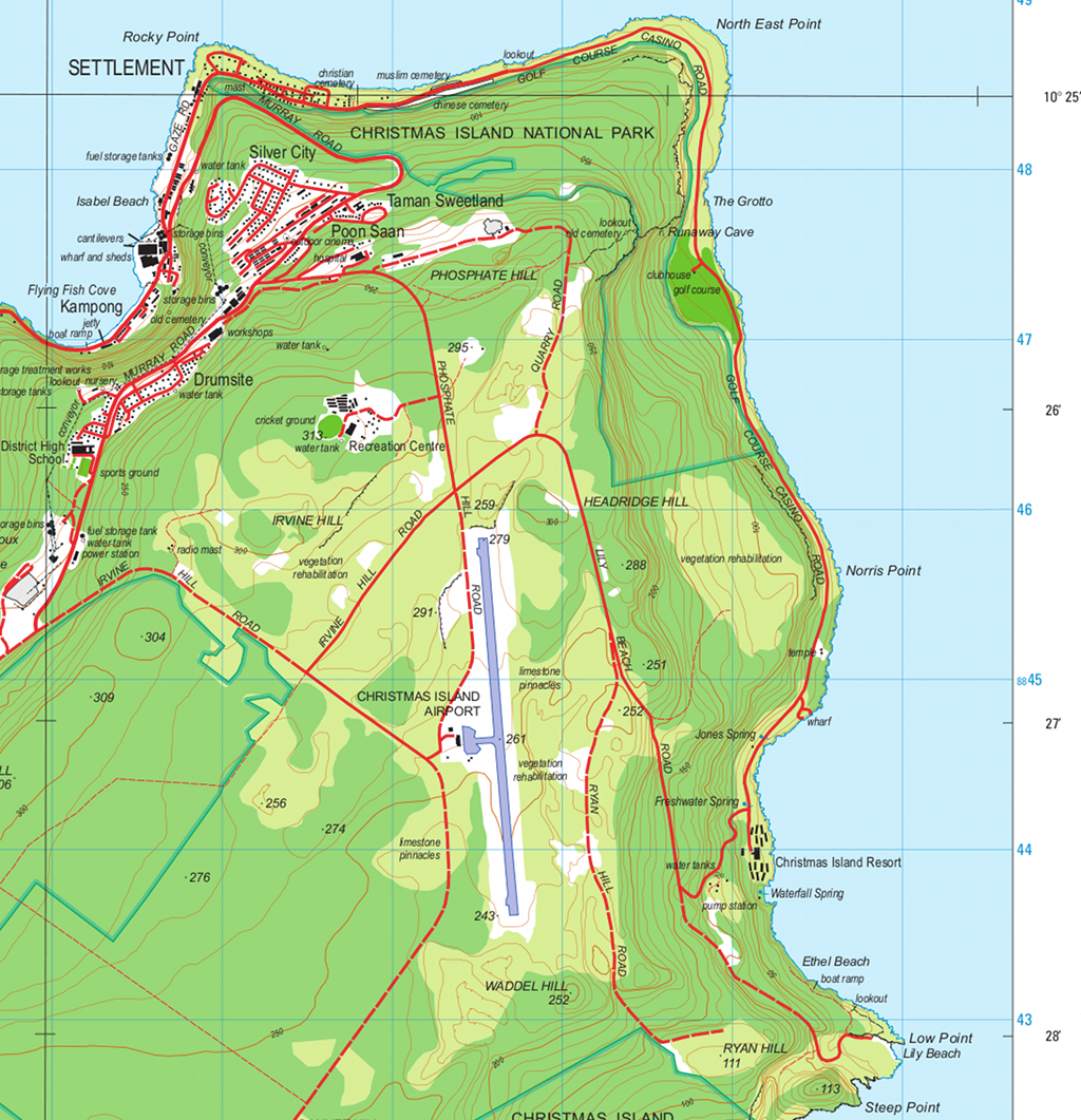 Figure 30. Redevelopment of the existing YPXM airport site into a dual 11,000 ft PCN100 runway system for civil and military use does not present unusual challenges given local terrain (© Commonwealth of Australia 2011). A naval replenishment facility presents significantly greater challenges, as the island has no large natural harbour. The existing Flying Fish Cove facilities built for phospate loading could be expanded and redeveloped, but the site cannot become another Apra Harbor, and severe problems arise seasonally with high sea states. An alternate container loading facility exists at Norris Point on the eastern tip of the island, but it is also not a protected harbour. Without major development, such as the construction of an artificial seawall, Christmas Island would be viable only for some naval resupply and replenishment activities, under favourable weather conditions, but would not be viable as a naval FOB. Christmas Island was the intended location for the construction of a major spaceport, with a launch facility at the island's South Point, to be operated by Asia Pacific Space Centre (ASPC) Pty Ltd. It was intended that a major airfield upgrade be performed to support the spaceport. The proposal did not eventuate, it appears due to undercapitalisation. The location is suitable for launches into both equatorial and polar orbits. The development of a major airfield compatible with 747-400 and A380 airliners would be a critical enabler for the local tourist industry, offsetting infrastructure costs over the longer term. A detailed study covering a runway upgrade to 8,700 ft (2.65 km) length, with an improved surface to accommodate heavy Boeing 747 and Antonov 124-100 aircraft, was performed by the Department of Transport and Regional Services in 2001, the intent being to provide the capability to support the proposed spaceport. The DOTAR submission to the Public Works Committee in 2001 stated [34]: “None of the environmental investigations carried out for the preparation of the EIS revealed any significant environmental impediments to the construction of the airport upgrade. Overall, the environmental impacts are considered to be minor.” As a hardened military airfield with a “dual-use” role would inevitably have a larger footprint than the proposed upgrade assessed in 2001, careful consideration will be required to accommodate local environmental constraints, given the fragility of the local ecosystem. |
||||||||||||||||||||
Environmental Considerations |
||||||||||||||||||||
| The Cocos
(Keeling) Islands and Christmas Island are acknowledged to be
environmentally sensitive, and are widely regarded to be national
assets. Both are home to national parks, the Pulu Keeling
National Park and the Christmas Island National Park. Both
locations
host a number of endangered wildlife species, but also a large number
of common species found across the atolls and islands of the
Indo-Pacific. Indeed, the Cocos (Keeling) Islands are a very typical tropical Indian Ocean atoll, very similar to those found in the Chagos Archipelago of the British Indian Ocean Territories, the Maldives, or some parts of the Seychelles. Conversely, Christmas Island is a volcanic seamount, with a tropical rainforest habitat, and due to geographical isolation, a large number of endemic species. The uniqueness of the wildlife has led to this island being sometimes labelled as the “Galapagos of the Indian Ocean”. The original ecosystems of both the Cocos (Keeling) Islands and Christmas Island have suffered severe damage resulting from human habitation. In the Cocos (Keeling) Islands, the native vegetation was mostly replaced with coconut plantations, with only North Keeling Island retaining the original Pisonia forests which covered both atolls. On Christmas Island, open cut phosphate mining led to the destruction of swaths of native rainforest. Much greater damage has been produced by invasive introduced species, especially the Yellow Crazy Ant Anoplolepis gracilipes, which is a problem species across the north of Australia, and common pests such as domestic rats, and feral domestic animals. Super colonies of the Yellow Crazy Ant, and the mainland Giant Centipede, Ethmostigmus rubripes, have produced serious environmental damage on Christmas Island, and are implicated in the likely extinction of one endemic species, and serious population losses in others. Any military facilities to be constructed on either of these sites will require very careful environmental management and planning to ensure that no further damage is produced to the local habitats and especially any endemic species. Moreover, logistical areas of airfields and naval berths must be robustly quarantined from the local habitat to ensure that invasive species which may be “hitch-hiking” on airlifted pallets, containers or vehicles cannot easily gain access to the rest of the local habitat. One advantage of military facilities is that access is inherently controlled, and thus unwanted human access can be largely denied. As a result, hunting, fishing or simple vandalism can be prevented, and feral animal species excluded or eradicated, the latter practice implemented on Diego Garcia. Moreover, controlled access presents opportunities for habitat repair, by replacing introduced vegetation with species previously destroyed. The latter is frequently not appreciated by many radical environmentalists, who have failed to see military installations for the opportunities they present in environmental repair and control. A military facility will require sewage installations, and a water desalination plant, with capacity to support up to several thousand personnel in a contingency. If implemented correctly, such installations would reduce existing stresses on groundwater supplies, and extant sewage systems. Large long term installations involving large numbers of personnel and heavy construction activities over a long period of time can be managed without significant environmental damage. The best case study of regional relevance is the oilfield on Barrow Island, a gazetted A Class Nature Reserve since the early twentieth century. Chevron, formerly WA Petroleum, have operated a substantial oilfield on Barrow Island since the 1970s, and more recently, have commenced the construction of a major LNG plant. 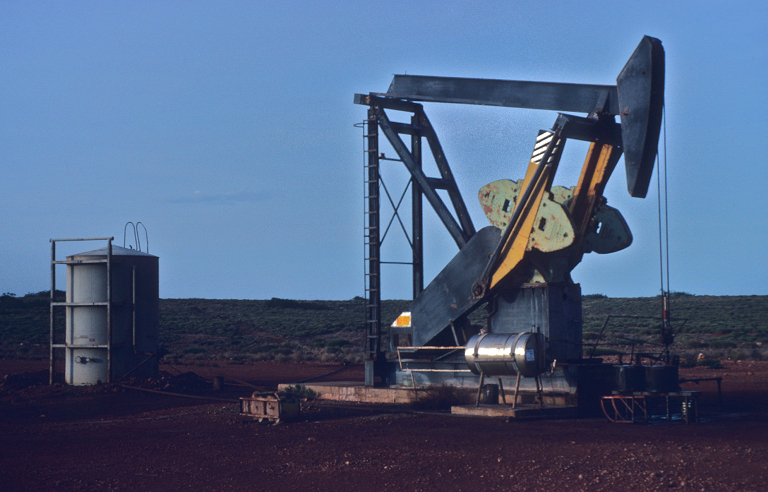 Figure 31. WA Petroleum operated Lufkin oil pump on Barrow Island in 1979. The white protective guard rail beside the pump was retrofitted to ensure that the endemic Barrow Island Euro, Macropus robustus isabellinus, did not have access to the area beneath the rocker arm, where these small kangaroos could suffer injury (© 1979 - 2012 Carlo Kopp). With a vested interest in retaining access, the company imposed stringent protocols for personnel working on the island. It is not well known that since the late 1970s, all refuse on the island was incinerated to deny its use as a food source for scavenging or predatory species, to ensure that the population balance between species was not perturbed. The company retained high profile advisors to ensure that the environment was carefully monitored, and any unwanted problems rectified [35]. Cocos (Keeling) Islands Environmental ConsiderationsThe principal challenge in the installation and long term operation of a major military airfield on West Island and a naval replenishment site on Dimension Island is ensuring that the fragile habitat of the central lagoon is not damaged.This lagoon is home to numerous coral species, a wide range of fish and sea snakes, but importantly is a safe haven for numerous species of sea turtle, especially the endangered Hawksbill sea turtle, Eretmochelys imbricata, and Green sea turtle, Chelonia mydas. Several hundred Hawksbill turtles, and thousands of Green turtles, are estimated to live in this lagoon [36]. A major consideration in the environmental management plan for the construction of the Rumah Baru jetty was ensuring that turtles were not injured by lagoon seabed dredging [37]. Dredging presents other risks, specifically as a result of silt carried by currents into areas not being dredged, and causing the death of coral species through suffocation. There are a range of established techniques for dredging to prevent such collateral damage from arising [38]. The concept for a naval wharf at Direction Island obviates this problem as it is emplaced outside the lagoon proper, with its supporting pylons located on the seabed outside Port Refuge. Subject to exact wharf placement, there may be no requirement for any dredging other than to emplace supporting pylons. Internal transport of heavy or bulk materiel between Direction Island and West Island could be implemented in two ways. One is transport across the lagoon using either a barge or an LCAC (Landing Craft, Air Cushion), the other is by constructing a “ring road” around the atoll. Both of these options were assessed and rejected during the initial studies which led to the eventual Rumah Baru jetty project, on the basis of cost and some unspecified environmental concerns [39]. A ring road implemented as an elevated causeway connecting the islands of the atoll would not produce large long term environmental impact, as seawater flow between the islets of the atoll would not be impaired by the concrete pylons supporting the prefabricated concrete spans. While this is a costlier option than procuring and operating barges or LCACs, it also does not disturb the lagoon ecosystem, and presents no boatstrike risks to turtles or other marine life [40]. Similar considerations apply to the transfer of bulk aviation kerosene from a Direction Island terminal to storage tanks on West Island. A six or eight inch pipeline could be laid across the lagoon at low cost, but the long term risk is that saltwater corrosion would result in fuel leaks into the lagoon over time. Embedding the POL pipeline in a “ring road” minimises pipeline exposure, and permits frequent access for inspection and repairs if required. Moreover, the concrete provides significant tolerance to bomb damage in wartime, and simplifies repairs and recovery. The construction of a hardened airfield installation on the northern portion of West Island will not yield significant impacts if properly managed. The vegetation is primarily a coconut plantation. What a hardened airfield does present an opportunity to do in appropriate areas, is the revegetation and thus replacement of the extant introduced plant species with the original species, such as Pisonia grandis, which are still present on North Keeling Island. At the time of writing a small scale revegetation effort was under way, by Parks Australia [41]. |
||||||||||||||||||||
Christmas Island Environmental ConsiderationsChristmas Island has suffered serious environmental damage over time, as a result of phosphate mining, but especially the impact of invasive species producing “ecological cascade failures” across multiple parts of the ecosystem [42].Beeton et al paint a bleak picture of the ecological situation on Christmas Island: “The Island has extraordinary terrestrial, subterranean and marine conservation values that are being diminished by management deficiencies and threats that are pervasive, chronic and increasing. Unfortunately, these problems will not have simple solutions. ... The EWG's recommendations set out the long-term and substantial changes that will be required for the successful future management of Christmas Island and its surrounding seas as a single ecological entity. We warn that a 'business as usual' approach in future will mean that management will fail and the extraordinary national asset that is Christmas Island's biodiversity will be replaced by a combination of many introduced and a few resilient native species. That outcome would be a failure in biodiversity conservation and would compromise the potentially secure economic future for the island as a tourist venue”[43]. The expansion of the airfield site on Christmas Island to accommodate a hardened military dual runway installation with HAS and hardened fuel and munitions storage would involve incremental expansion of the existing airfield site. The area proximate to the existing airfield is currently being revegetated to repair previous damage from mining operations [44]. As the installation would be performed in an area where previous environmental damage was done, the opportunity presents to perform more extensive remediation work within the perimeter of the expanded airfield site, as part of the construction effort, and to maintain a tightly controlled environment once the site is operational. Moreover, the installation of a desalination plant to support the airfield presents an opportunity to reduce stress on the extant island groundwater supply [42]. |
||||||||||||||||||||
The Australian Defence Force Posture Review Interim Report |
||||||||||||||||||||
|
The Interim Report covering
the Australian
Defence Force Posture Review was released in late January, 2012.
The report is in many key respects an
important advance, as it
correctly identifies a wide range of necessary improvements to ADF
basing in Western Australia, until recently not acknowledged as either
necessary or relevant by the Department of Defence.
The most important of the Preliminary Conclusions are cited thus:
The principal area of concern is the manner
in which capability upgrades to airfields have been defined, in terms
of specific RAAF aircraft types, such as the KC-30 tanker and P-8A LRMP
aircraft, neither of which present especially challenging runway
strength and length requirements. If runway and taxiway upgrades are
constrained in implementation to these aircraft types, these bases
would remain inaccessible to larger and heavier aircraft, such as heavy
civilian transports or a number of heavier US Air Force aircraft types.
The latter in turn diminishes the strategic value of each and every
base subjected to such a constrained upgrade. The incremental cost of
making the upgrade compatible with larger and heavier aircraft is not
prohibitive, compared to the overall cost of any substantial runway
upgrade in a remote area, and also is as stated previously, an enabler
for high volume commercial traffic.
Of similar concern is that the definition of airbase ‘hardening’ and resilience improvement (27) does specify explicitly the use of Hardened Aircraft Shelters and hardened bunkers for facilities, leaving the outcome open to interpretation. The proposed upgrade of RAAF Pearce is appropriate (24), but with an unrestricted runway. Pearce should also be upgraded to permit the permanent basing of a fighter squadron in Western Australia, to minimise transit times to the Pilbara and Kimberley, and also to provide an in situ capability to defend HMAS Stirling without the cost and time overheads of deployment from New South Wales or Queensland. In effect, RAAF Pearce would play the same role as RAAF Cunderdin did during the 1940s, as the principal basing hub for operations in Western Australia. Basing upgrades to the Cocos (Keeling) Islands (11) are limited to airfield improvements, while no upgrades to Christmas Island facilities are proposed. |
||||||||||||||||||||
ConclusionsThe central conclusion this study draws is
that a deep and comprehensive upgrade of the basing infrastructure in
the Pilbara and Kimberley is essential to permit Australia to maintain
its strategic position in the region, safeguard the economically
important energy and resource industries of the North-West, and that
further important strategic advantages can be gained by the
construction of modern hardened basing infrastructure in the Cocos
(Keeling) Islands and Christmas Island.
Moreover, there are other important strategic and political payoffs in such basing upgrades, in both Military Operations Other Than War, in supporting Australia's principal ally, the United States, and in facilitating the growth of the tourist industry by providing dual use capabilities in key basing locations. Basing upgrades will require that the fragile environment in this geographical region is respected and carefully addressed in base upgrade or new construction planning. |
||||||||||||||||||||
Notes
and Acknowledgements
|
||||||||||||||||||||
|
This study is not the first proposal to
establish a permanent military basing infrastructure on the Cocos
(Keeling) Islands, or Christmas Island.
The 1956 strategic policy paper entitled “THE STRATEGIC BASIS OF AUSTRALIAN DEFENCE POLICY” endorsed on 11th October, 1956, by the then Defence Committee, stated: “Cocos Island should be held as an important forward base...Preparations for the defence of the north-west approaches to Australia will depend on the probable form and scale of attack at any given time....in the event of a Communist-controlled Indonesia actively threatening these approaches, military operations may be necessary against that country to provide depth to the defence of the north west approaches to Australia, and to prevent the development of a substantial air threat to Australia...In the event of Indonesia becoming Communist, an air threat could develop more quickly than an invasion threat.” While the threat assessment of that period reflected the advance of Communism through South-East Asia, the rationale for deployments and operations reflects immutable geographical realities. Ross Babbage revisited this topic in a 1988 ANU SDSC monograph entitled “Should Australia plan to defend Christmas and Cocos Islands?”. More recently, the Australian Strategic Policy Institute has repeatedly published on the theme of Indian Ocean strategy, and an exceptionally good monograph was produced in March, 2010, by Anthony Bergin and Sam Bateman, entitled “Our western front: Australia and the Indian Ocean”. This author has also produced a series of shorter publications for Defence Today journal covering Indian Ocean themes in 2011 and 2012, based on the same research materials as this study, and the author gratefully acknowledges the support of the publisher, John Armstrong, in exploring and publicising this important topic. A great many individuals contributed insights, expert opinion and ideas to this study. The author thanks Peter Goon, APA co-founder, members of the APA editorial board, WGCDR Chris Mills (Retd), and of course, the peer reviewers who invested considerable time on the draft of this document. Any omissions or faults are the responsibility of the author. |
||||||||||||||||||||
References and Bibliography
|
||||||||||||||||||||
Annex
A Airbase Hardening Considerations
|
||||||||||||||||||||
|
Australia has no history in the design or
operation of modern hardened
airbases. The extant RAAF bases at Learmonth, Curtin, Darwin, Tindal
and Scherger employ characteristic dispersal areas, in which aircraft
are protected by conventional revetments, with lightweight roofing to
reduce the exposure of the aircraft to tropical sunlight and weather
[45].
This arrangement would be reasonably effective against a low level strafing attack using guns, or a low level rocket or dive bombing attack, using unguided weapons. It is ineffective against Precision Guided Munitions, especially if supported by contemporary ISR systems. As popular as dispersal might be in much contemporary military thinking, it is no longer a viable strategy given the global proliferation of modern ISR. 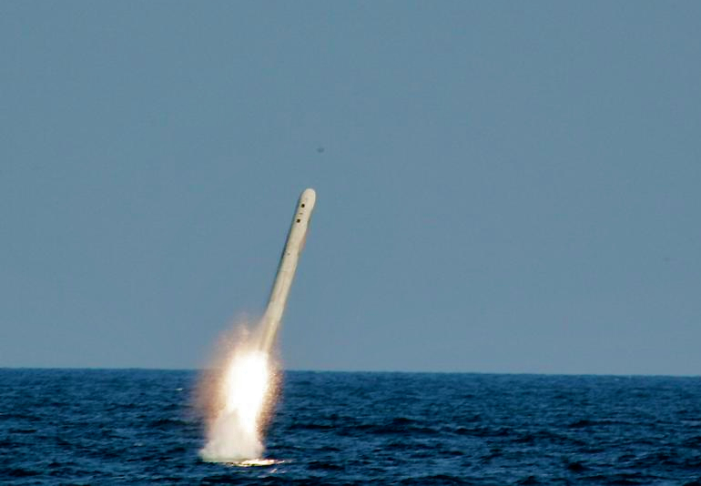 Figures A.1, A.2 Submarine
launched Tomahawk cruise missiles (depicted) proved very useful during
the Odyssey Dawn pre-emptive attack on Libya's air defence system in
March, 2011. The capability is no longer unique to the United States
and its allies, as the similar Russian Novator 3M14E Club cruise
missile has been widely exported to operators of the Kilo-class diesel
electric submarine (US Navy).
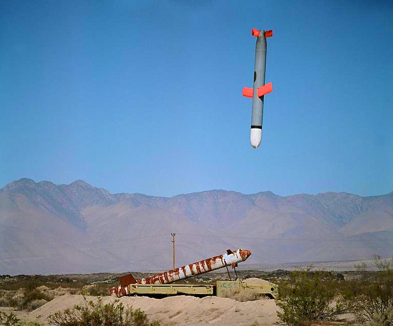  Figure A.3, A.4 Given the
proliferation of cruise missiles with precision
guidance, revetments are no longer an effective means of protecting
parked aircraft (US Navy).
 Given capabilities extant across South East
Asia and the Far East, the
expectation that in any conflict a regional nation would choose to
employ unguided weapons in attacks against ADF basing, rather than
readily available warstocks of Precision Guided Munitions, is
unrealistic in the extreme.
Historically, attacks on airbases have had two distinct aims. One has been the destruction of aircraft on the ground, and the other critical base infrastructure, such as runways, taxiways, fuel storage, munitions storage, electricity generation, navigational aids and other supporting systems and equipment. Future hardening of ADF basing must reflect this reality, and respective capabilities deployed across Asia. Weapons which could be deployed against ADF basing vary in effects. The most effective weapons are typically the most difficult to deploy, such as the Russian 1,500 kg KAB-1500 series of guided bombs, which must be deployed by a large fighter in the Flanker series, which in turn must penetrate defences and overfly the target to effect a delivery. Conversely, the weapons which are least effective against well hardened facilities are the least difficult to deploy, specifically various land attack and air launched dual role standoff missiles and cruise missiles, and ballistic missiles. The best study to date on the risks of unhardened basing in the Pacific Rim was produced by Stillion [24]. Stillion's study focussed primarily on the effects of PLA ballistic missile attacks on United States and allied basing in the West Pacific region, such as Kadena, Yokota and Guam. His findings are however equally applicable to all guided muntion categories, and ADF basing infrastructure. While runways and taxiways can be repaired rapidly, and advances in rapid repair technology in recent years permit this to be done faster than in any previous conflict, hardening other infrastructure is much more challenging, and protecting aircraft even moreso. 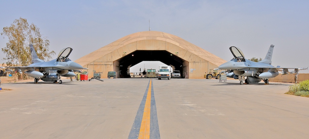 Figure A.5, A.6 A modern Hardened
Aircraft Shelter at
Balad AB in Iraq (US Air Force).
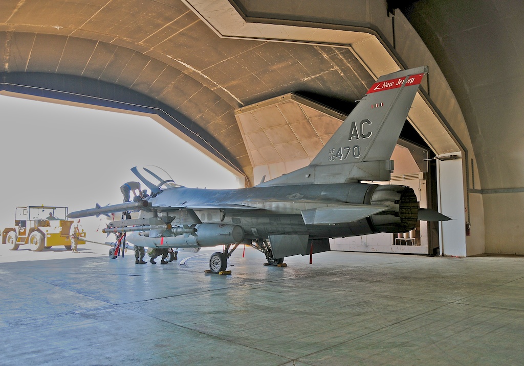 Protecting aircraft from guided munitions is the most challenging task. Hardened Aircraft Shelters are not a panacea, but significantly increase the difficulty to an opponent in attacking aircraft on the ground. While layered active defence measures for airfields, comprising interceptor aircraft, long, medium and short range Surface to Air Missiles, short range guns, and in the future, directed energy weapons, are important means of preventing attacks on airfields, they do not obviate the need for passive defensive measures such as hardening, regardless of whether such airbases are occupied on a permanent or transient basis. This is because no active defence system is impermeable to attacks, and any active defence system can be eventually overwhelmed by weight of fire, be it in saturation attacks or sustained attacks intended to drain warstocks of munitions. The collapse of the United States monopoly on stealth technology exacerbates these problems, as many such threat systems will be extremely difficult to defeat by conventional active defences. Airbases present attractive targets as they present the highest concentration in time and space of aircraft, the destruction of which will always be one of the highest priorities for an attacker. The relatively high cost of many passive defence measures must be weighed carefully against the cost of active defences, which are typically even higher, and increase considerably with increasing coverage footprint, capability, redundancy and robustness. This is especially important for smaller nations like Australia, which are limited in personnel numbers and resources available to fund large standing in situ air defence forces. An important case study is the extensive use of passive defences by smaller nations during the Cold War era, examples being Switzerland, Yugoslavia, and to a lesser extent, Sweden. China's Cold War era use of passive defences, while on an enormous scale, reflects its assessment of the numerical and technical superiority of Soviet and United States air power during that period. The 1991 Desert Storm campaign saw 375 of Iraq's 594 Hardened Aircraft Shelters, some well designed and built, destroyed by repeated attacks, using 2,000 lb class BLU-109/B Have Void concrete piercing warheads. Many shelters were destroyed in initial attacks, but many required reattacking to defeat. More recent US designs such as the subcalibre 2,000 lb class BLU-116/B Advanced Unitary Penetrator (AUP) and 1,000 lb class AUP-3M will penetrate up to 12 ft of high density reinforced concrete. The GBU-39/B Small Diameter Bomb is credited with the ability to penetrate 6 ft of high density reinforced concrete. The Russian KAB-1500L-Pr penetrator is credited with the ability to penetrate 30 ft of soil overburden and then 6 ft of reinforced concrete. A credible Hardened Aircraft Shelter built for the future, rather than the past, must have the capability to defeat contemporary and future upper tier concrete piercing weapons. This will require not only thick walls and roofs constructed from dense and thick reinforced concrete, but also technologies such as deflection grids designed to produce warhead casing ruptures on impact, and entrance designs which are not easily compromised by a guided bomb or missile entering at a very shallow angle. Superhardened large concrete structures were constructed in significant numbers during the Second World War by Germany's Todt Organisation, to protect submarine pens, ballistic missile sites, and as Flak Towers. These proved unusually difficult to defeat. Some were destroyed using British 12,000 lb Tallboy and 22,000 lb Grand Slam earthquake bombs, but many were also never defeated [46][47]. The alternative of deep underground hangars, tunnelled into hillsides, has been employed extensively by Switzerland, but especially China [48]. 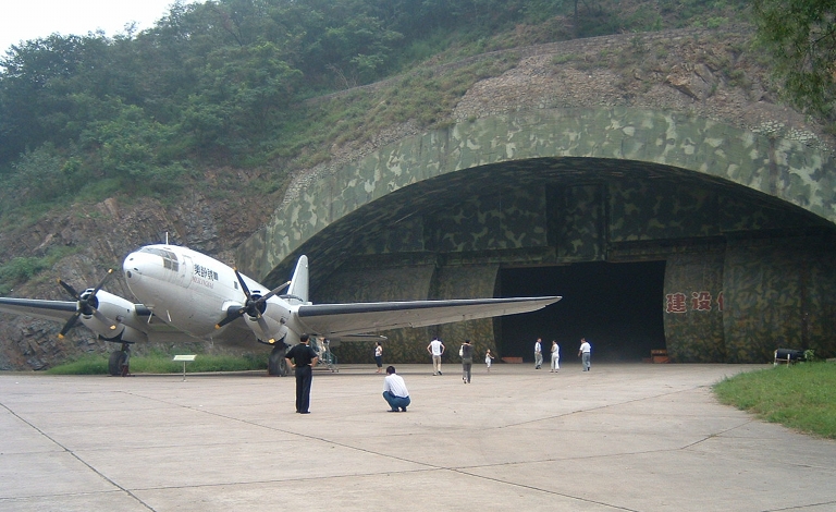 Figure A.7, A.8 Exterior view of
blast door arrangement at the inactive Luyan / Ranghe-Zhen airbase and
interior view of hangar. The recently expanded PLANAF airbase at
PLA-NAF Ledong / Foluo Northeast on Hainan Island is very similar in
design and can protect twenty H-6 Badger theatre bombers, each similar
in size to a larger Boeing 737 variant (Chinese
Internet).
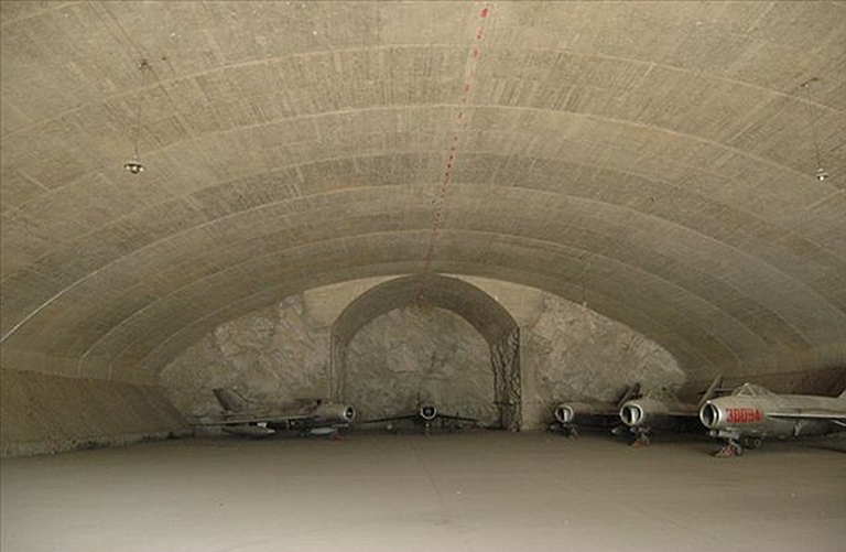 Unfortunately, Australia lacks the geographical abundance of suitable rocky hills and mountains which the Swiss and Chinese have so adeptly exploited. Hardening of basing in the Pilbara, Kimberley, Northern Territory, and Indian Ocean Offshore Territories, will require pouring prodigious amounts of concrete. Fortunately, the latter is something Australian industry has considerable expertise and experience in doing. The technology of Hardened Aircraft Shelters for single fighter sized aircraft is mature, although there are no recent Western designs which have been developed to defeat state of the art guided weapons with concrete piercing warheads. Legacy designs developed during the Cold War TAB-VEE program will not be sufficient, as the capabilities of concrete piercing munitions have improved considerably since the Cold War. The greater challenge is however the development of Hardened Aircraft Shelters capable of protecting large aircraft, such as tankers or Airborne Early Warning and Control (AEW&C) aircraft, as proposed by Stillion [24]. Stillion in his groundbreaking 2008 study
proposed large
shelters with 12 foot thick roofs
and 9 foot thick walls, modelled on the German submarine pen scheme,
capable of protecting either 36 fighters, or 12 large aircraft like
tankers, each. Cost estimates for such a shelter were around US$700
million in 2008, but capable of sheltering billions of dollars of
aircraft against a wide range of guided and unguided munitions.
The technology is clearly available to
construct individual Hardened Aircraft Shelters for fighters and large
aircraft, but by the same token, there are no “off-the-shelf” designs
available which have been proven in tests with representative state of
the art concrete piercing warheads.
Hardening runways and taxiways has historically involved the use of concrete surfaces, and extensive redundancy, such as parallel runways, or taxiways capable of use as temporary runways. A strategy used with some success has been to connect individual fighter sized shelters to runways with individual taxiways, forcing an opponent to cut every taxiway to isolate all shelters. A major consideration for basing upgrades in the Pilbara, Kimberley and Indian Ocean Offshore Territories will be the durability of the concrete employed, given the environmental exposure to salt water characteristic of the region. Corrosion of ferrous metal structures in proximity to the coastline is a well established problem for the resource industry in this region. Careful choices will be necessary, and it is likely that Ground Granulated Blast-furnace Slag (GGBS) high strength concrete will need to be used heavily. This category of material was favoured by Soviet designers in hardened military installations. An example of a hardened airbase concept sized for extant RAAF northern bases is depicted in Figure A.9. It does not include a shelter for large aircraft such as tankers. 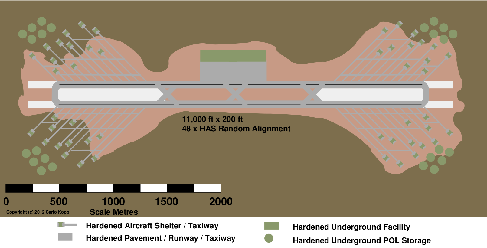 Figure A.9 Example hardened airbase
configuration with 48 HAS (C. Kopp).
|
||||||||||||||||||||
Annex B
Case Studies of Island Basing - Guam and Diego Garcia
|
||||||||||||||||||||
B.1 GuamGuam is largest of the micronesian islands, and the southernmost volcanic island in the Mariana's chain, comprising Saipan, Anatahan, Sarigan, Guguan, Alamagan, Pagan, Agrigan, Asuncion, Maug, Uracas, Saipan, Tinian, Rota and Guam [47].The Marianas were first discovered by Europeans in 1521, during Magellan's circumnavigation of the globe. There are conflicting claims that Magellan named these islands the “Islands of Thieves”, or the “Islands of Latin Sails”. The Marianas were inhabited since 2000 B.C. by the indigenous Chamoru people, who are best known for constructing stone megaliths. 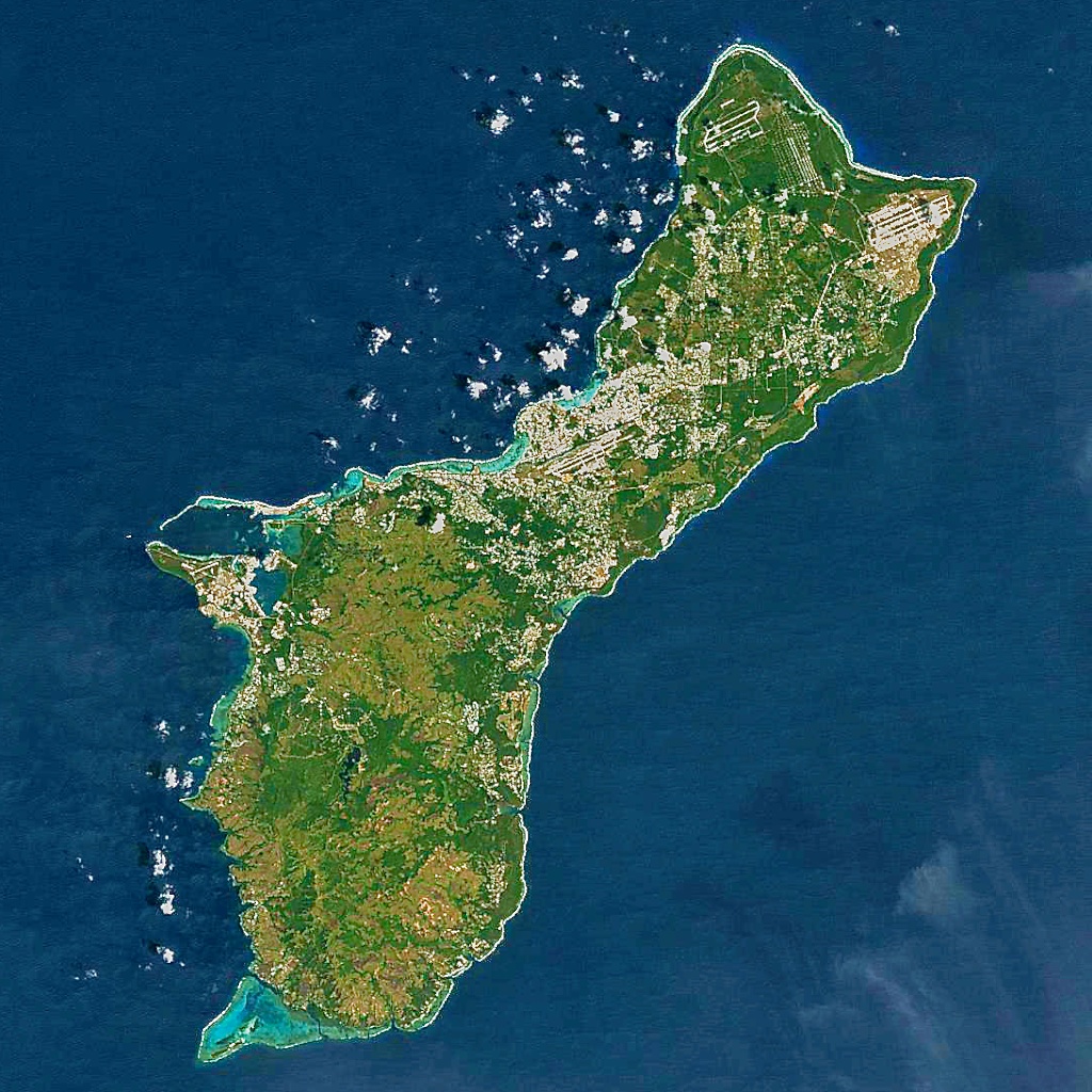 Figure B.1 Guam imaged by Landsat 7
(NASA).
The Spanish, by then established in the Philippines, initiated colonisation of the Marianas in 1668, when a party of Jesuits arrived to convert the islanders to christianity. This was not a happy union, resulting eventually in an indigenous insurgency, Spanish reprisals, and a claimed collapse from a population of 150,000 down to 5,000. Most of the Chamoru were relocated to Guam, while their vacated lands were repopulated by Filipinos and Carolinians. 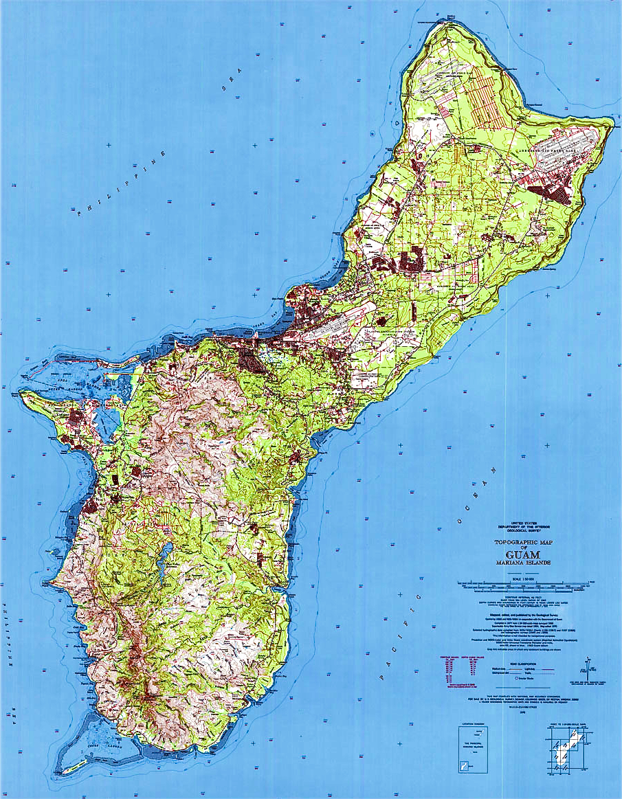 Figure B.2 Topographical
map of Guam (USGS).
Spain sold the Northern Marianas to Imperial Germany in 1899, while Guam was lost to the United States a year earlier, in 1898, under the treaty of Paris. The US retained control of Guam until 1941, when advancing Japanese forces overran the island. The Japanese were by then well established in the Northern Marianas, having occupied these at the beginning of the Great War and administered them under League of Nations mandate since 1918. The Japanese heavily fortified the Marianas, using them as forward operating bases and integrating them into the chain of defences around the Japanese home islands. Many Japanese and indigenous Okinawans were relocated to the islands to support the Japanese military. The US invasion force first landed on the beaches of Saipan in June, 1944, losing over 3,000 troops while overwhelming the 29,000 strong Japanese garrison. The Japanese counter-attack, the Battle of the Philipine Sea, result in a rout of the Japanese fleet and the now famous “Marianas Turkey Shoot” in which hundreds of Japanese naval aircraft were lost. Within weeks the Marianas were overwhelmed, and the US initiated construction of a cluster of airfields, intended for the basing of B-29 bombers for attacks on Japan. Tinian Island became the nucleus of this cluster, with the four Japanese built runways rebuilt, and additional two constructed. Guam's Apra Harbour was rebuilt, and the North and NorthWest Field sites on Guam was developed for B-29 basing. Saipan saw the development of two B-29 runways at Kobler and Isely Fields. The first B-29 raid against Japan was flown from the Marianas in late November, 1944. General Curtis E. Lemay's B-29s fire bombed Japan's cities, mined Japan's shipping lanes, and ultimately, delivered two nuclear weapons, bringing the Pacific war to a close in 1945. 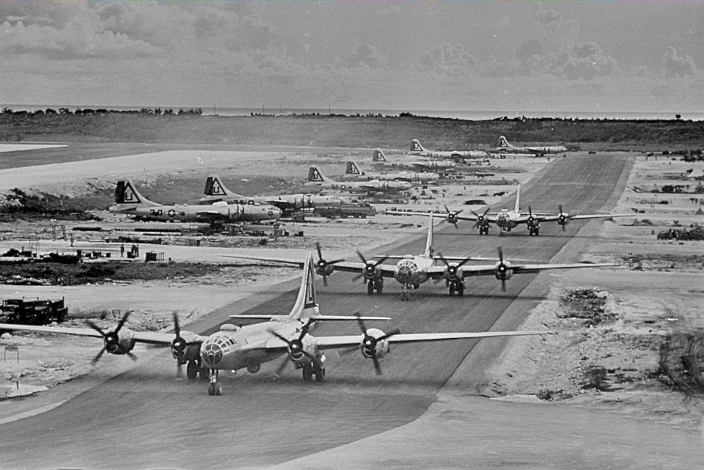 Figure B.3 B-29 Superfortresses of the 462nd BG, taxiing to the holding point at West Field, Tinian, in 1945. Gen Curtis LeMay's B-29s burned down most major cities in Japan, as well as destroying more coastal shipping than Navy submarines did by mining shipping lanes (USAF). 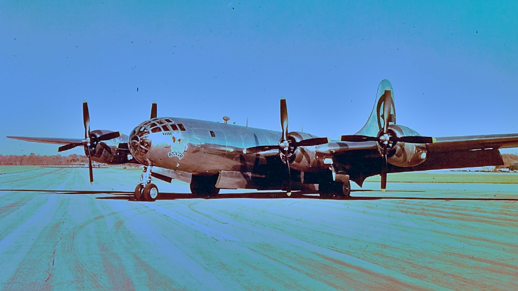 Figure B.4 B-29-35-MO
AAF Serial No. 44-27297
of the 393rd BS, 509 BG, used to obliterate Nagasaki in August, 1945
(USAF).
With the end of World War II and slowly escalating Cold War, the Marianas remained a strategically important site for the United States, although bases in Japan and the Philippines were primary sites for projecting power into Asia. Guam's North Field hosted the only heavy bomber unit to remain deployed in the Pacific after 1945. North Field was renamed North Guam Air Force Base in 1947, and then renamed again to Andersen AFB in 1949, after Brig. Gen. James R. Andersen. who was lost while ferrying a B-24 across the Pacific. Guam became an important staging point for aircraft deploying to the Western Pacific bases. During the Cold War, Andersen AFB hosted B-36, B-47, B-50, B-52, B-29, KC-97 and KC-135 aircraft, flown by Strategic Air Command. The escalating conflict in Vietnam saw Guam reprise its 1944-1945 role as a bomber base, becoming a key operational base for B-52 raids flown against North Vietnam, and their ground forces in the South. In June, 1965, 27 B-52s launched from Andersen to fly the first of the long running series of Arc Light sorties against PAVN troops in the South. By early 1972, Andersen hosted 153 B-52s, being flown against PAVN targets. The US Air Force states that no less than five miles of taxiway were required to park these aircraft.  Figure B.5 The Vietnam conflict saw Guam heavily used as a base for B-52s conducting Arc Light raids in the South, and later the Linebacker II raids against the North. Up to 153 B-52s were flown at any time from Andersen AFB (U.S. Air Force).  Figure B.6 Parking and managing the flow of B-52s operating from Andersen AFB presented major issues during the intensive bombing campaigns of the Vietnam conflict. These Buffs are about to sortie during Linebacker II (U.S. Air Force). The peak of operations from Andersen occurred during the 11 days of the Linebacker II bombing campaign in late 1972, when 379 or 52% of the total number of B-52 sorties flown launched from its runways. On one occasion, no less than 87 B-52s took off in 1 hour and 43 minutes. The end of the Vietnam War saw Andersen return to its peacetime role as a strategic base and logistical hub for Western Pacific operations. The base has played an important logistical role in every major contingency since then, supporting operations in the Persian Gulf and Afghanistan. Ongoing tensions with North Korea over its nuclear program, and the growing militarisation of the West Pacific region has seen Guam's prominence as a forward operating location increase. For some years, Andersen AFB has hosted continuous rotating deployments of B-52H, B-1B and B-2A bombers. The February, 2008, crash of a B-2A on takeoff from Andersen, due to water ingress into the flight control sensors, occurred during such a deployment from the bombers' home base in Missouri. Guam currently hosts a range of US military facilities, divided between US Navy and US Air Force assets. In the near future, Guam will also see a substantial US Marines Corps presence, as units are relocated from Okinawa in Japan. The US Air Force presence is concentrated at Andersen AFB, which is home base to the 36th Wing. The 36th Wing is a base support unit, comprising 36th Mission Support Group, 36th Communications Squadron, 36th Civil Engineering Squadron, 36th Contracting Squadron, 36th Logistics Readiness Squadron, 36th Mission Support Squadron, 36th Security Forces Squadron, 36th Services Squadron, 36th Medical Group, 36th Maintenance Group, 36th Maintenance Squadron, 36th Munitions Squadron, and the 36th Operations Group. Additional units on the base include the 254th Air Base Group, 337th Air Support Flight – Australia, 44th APS, 497th Combat Training Squadron, 554th Red Horse Squadron, 734th Air Mobility Squadron, Det. 5 of the HSC-25 Island Knights helicopter squadron, and AFOSI Det. 602.  Figure B.7 Andersen AFB is now home to rotating detachments of heavy bombers, home based in the continental US (U.S. Air Force).  Figure B.8 The B-2A is now a regular visitor at Andersen AFB. To support such deployments, a transportable hangar was designed, permitting field maintenance of stealth materials (U.S. Air Force). Andersen AFB is currently hosting a permanent deployment of heavy bombers, rotated through the base from US based bomber wings. The base is also frequently hosting fighter units, rotating through from fighter wings home based in the US. Regular exercises also see Japanese Air Self Defence Force fighter units flying out of Guam, especially to make use of the bombing range in the Marianas. The live fire range is located at Farallon de Medinilla Island (FDM), 45 NMI from Saipan, the 200 acre site being leased from the Marianas Commonwealth since 1975. Andersen is now seeing a major construction effort to expand facilities. New and planned facilities include a corrosion control facility, fuel cell facility, hangar space and a “bird bath” to wash aircraft, further hangars, a medical and dental clinic, a military working dog facility, water tanks, and an RQ-4 Global Hawk UAV maintenance complex. Also intended are a new bank, dining facility, maintenance facilities, dormitories and base housing. In strategic terms, Andersen AFB is a key geographical hub for the US Air Force, as it provides for coverage of South East Asia and Southern China. Moreover, it sits outside the striking radius of most aircraft based on the Asian mainland, unlike the bases in Japan and South Korea. Naval facilities are centred around Apra Harbour, a natural deep water anchorage on the western coast of Guam. The northern portions of Apra are a civilian port and the main hub for commercial traffic through Guam. The southern portions of the port belong to the US Navy. The 4,000 ft Orote air field strip is located on the Orote peninsula to the west of Apra. The Navy operates Apra Harbour, the Guam Ordnance Annex, Naval Computer and Telecommunications Station [NCTS] at Finegayan Point. The former Naval Air Station Agana has been disposed of and is now Guam International Airport, with dual 8,000 ft runways. 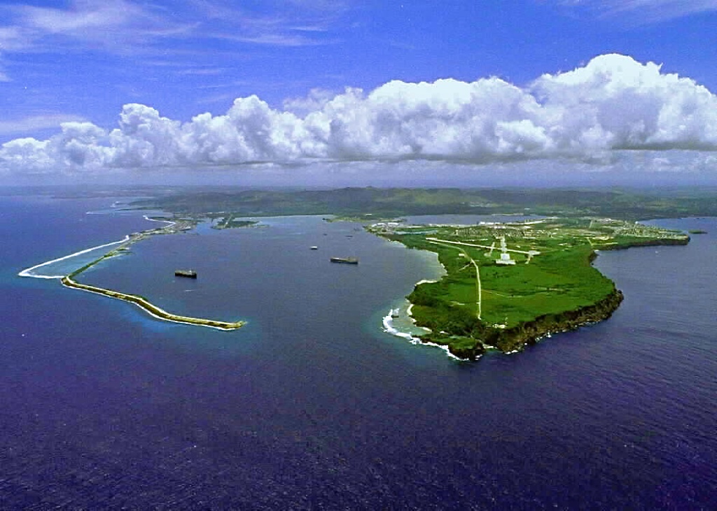 Figure B.9 Apra
Harbor, Guam (U.S. Navy).
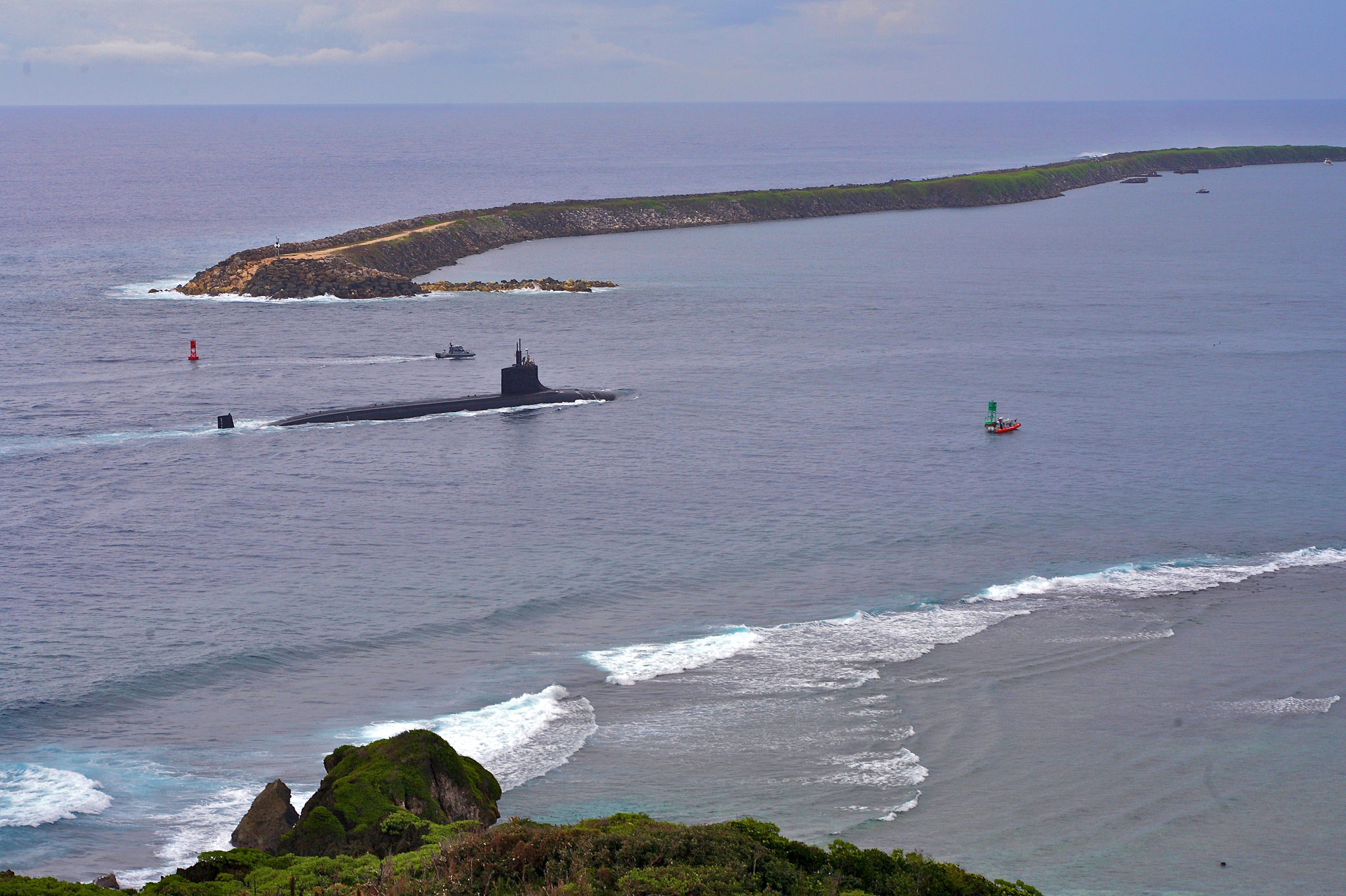 Figure B.10 SSN-21 Seawolf entering Apra Harbour, Guam. Apra is home port to Submarine Squadron 15, comprising a tender and three Los Angeles class attack submarines (U.S. Navy).  Figure B.11 Apra includes a valuable shipyard facility for the repair of naval vessels. Depicted is SSN-711 USS San Francisco undergoing emergency repairs at Apra after ran underwater collision with a seamount near Guam in 2005 (U.S. Navy).  Figure B.12 Kilo Wharf at Apra Harbour is a munitions loading facility. This aircraft carrier is reloading its magazines at Kilo Wharf before departing for operations (U.S. Navy). Apra Harbour is a major Pacific hub for the US Navy, and includes a submarine base built during the Cold War to support a squadron of Polaris SSBNs, a naval shipyard with drydock facilities for the repair of surface ships and submarines, Kilo Wharf capable of loading and unloading ammunition ships to full draft, and handling aircraft carriers. Apra has hosted, since 2001, SUBRON 15, currently comprising the submarine tender USS Frank Cable (AS 40), and Los Angeles class attack submarines USS Buffalo (SSN 715), USS City of Corpus Christi (SSN 705), and USS Houston (SSN 713). The Ordnance Annex Guam, formerly Naval Magazine, is a major munitions storage facility located around 1 nautical mile south east of Apra. The NCTS at Finegayan is located around 5 nautical miles north of Guam Int. airport. Navy units hosted include the Defense Supply Center, Defense Distribution Depot Guam Marianas (DDGM), Documentation Automation & Production Service, Detachment Civic Action Team, Explosive Ordnance Disposal Mobile Unit 5, Helicopter Sea Combat Squadron 25, Maritime Expeditionary Security Squadron 7, Maritime Prepositioning Ship Squadron 3, Mobile Mine Assembly Unit 8, Naval Airborne Weapons Maintenance Unit 1, Naval Computer and Telecommunications Station Guam, Naval Facilities Engineering Command Marianas, Navy Legal Service Office Pacific Det. Guam, Navy Operational Support Center Guam, U.S. Naval Hospital, Guam and a Personnel Support Detachment In strategic terms, Guam is now also a critical basing hub for the US Navy, not only hosting the submarine squadrons intended to patrol the West Pacific, but providing a logistical node for replenishing surface fleet assets such as carriers and supporting surface combatants with munitions, fuel and other stores and provisions. The next major development for Guam is the relocation of 8,000 Marines currently based in Okinawa. The Marine Corps presence in Okinawa has been a long running political problem for the US and Japan, as it has become the subject of long running disputes between the ethnic indigenous Okinawans and the central government in Tokyo. This has been compounded by population growth in Okinawa resulting in creeping urban encroachment and resulting noise complaints, a problem not unique to Okinawa. The relocation of the Marines is part of a much large package of base restructuring and relocation measures, negotiated with the Japanese Government in 2006. These measures include consolidation of air force basing in Japan, co-location of a JASDF air defence command centre at Yokota in the Tokyo suburbs, and relocation of the Marines and up to 10,000 dependents to Guam. Japan will be providing a substantial portion of the tens of billions of funding required for the basing restructure. This effort is the single largest restructure in West Pacific US basing since the withdrawal of US forces from the Philippines at the end of the Cold War. Okinawa is currently home to the III Marine Expeditionary Force, with more than 23,000 Marines, supporting Navy personnel and dependents located on the island. Component units include the 3d Marine Expeditionary Brigade, the 3rd Marine Logistics Group, the 1st Marine Aircraft Wing, the 3D Marine Division, the 31st Marine Expeditionary Unit, and the Marine Corps Air Station Futenma. Marine Corps Air Station Futenma currently hosts Marine Aircraft Group 36 and Marine Air Control Group 18. Futenma is to be transferred to the JSDF as part of the restructure, and new airfield was to be built offshore. This plan has been complicated by a campaign conducted by ethnic Okinawans to have all of the Futenma basing relocated to Guam, in direct opposition to Tokyo. Public briefing materials indicate that by the end of the restructure, planned for 2012, the III Marine Expeditionary Force will be sited at Guam. This will coincide with further growth across all US military forces in Guam. The US Air Force is to increase the number of transiently deployed fighters, bombers, tankers at Andersen, and will likely permanently base Global Hawks at the site. The US Navy is to increase the number of logistical vessels operating from Apra, and provide more frequent transient berthing for carriers, as well as basing new HSV hulls at Apra. The US Army is to locate an Air Defence Battalion with 630 personnel and 900 dependents on Guam. Overall estimates for deployed personnel and dependents indicate growth from 2007 figures of 6,420 active duty personnel and 7,690 dependents, to 19,230 active duty personnel and 19,140 dependents. This is a 170 percent increase in the total number of personnel and dependents hosted on Guam. In addition, construction workers will be based on Guam while the infrastructure is expanded. The current planning for Guam is intended to provide incremental increases in Air Force and Navy basing capabilities, and accommodate the III MEF. Perhaps the biggest longer term issue for Guam is that most of its facilities are not hardened. This has not been a problem in the past, as no nation in the West Pacific had the reach to hit Guam, other than Soviet strategic bombers and ballistic missiles, during the Cold War. This is now changing, with China developing a strategic bomber force, likely around indigenous new build turbofan power Xian H-6K Badgers, deploying terminally guided Intermediate Range Ballistic Missiles, and Tomahawk-class cruise missiles on nuclear attack submarines. Post 2010 Guam, like all US basing in the West Pacific, will be under the footprint of Chinese ballistic missiles and cruise missiles, all weapons with the precision to render these bases unusable in combat. During the Cold War the US conducted the Tab-Vee program across NATO hosted bases to provide hardened aircraft shelters, the aim being to deny the Soviets the option of rapidly crippling all US air bases in the theatre using conventionally armed ballistic missiles and fighter-bombers armed with cluster munitions, dumb bombs and some precision guided munitions. No such effort was ever conducted in the Pacific. The strategic reality now is that China and other nations across the region are acquiring a diverse and large warstock, spanning smart bombs with a range of different guidance systems, standoff missiles, cruise missiles and terminally guided ballistic missiles, the latter exemplified by the DF-21 series. The presents the US with the reality that its unhardened West Pacific basing infrastructure will be directly exposed to the largest global concentation of precision guided munitions other than the US national warstock, in fact a much higher concentration than deployed by the Warsaw Pact in the last years of the Cold War. This amounts to a more dangerous strategic environment pitted against basing infrastructure which is no more hardened than continental US basing facilities. The strategic consideration for Australia is thus simple. If the US does not harden Guam and other West Pacific basing against precision guided munition attacks, the result of any major regional conflict could be a significant loss of US forward deployed capabilities as these bases are crippled and rendered unusable. B.2 Diego
Garcia (British Indian Ocean Territories)
Diego Garcia is a coral atoll located in the Chagos Archipelago, which
is part of the British Indian Ocean Territory (BIOT). Britain purchased
the complete Chagos Archipelago from Mauritius in late 1965. Until
then, the primary economic output of the islands were coconut
plantations, with the local population of around 1,000 persons
surviving on coconut production. |
||||||||||||||||||||
Annex C Regional Instances of Military Operations Other Than War |
||||||||||||||||||||
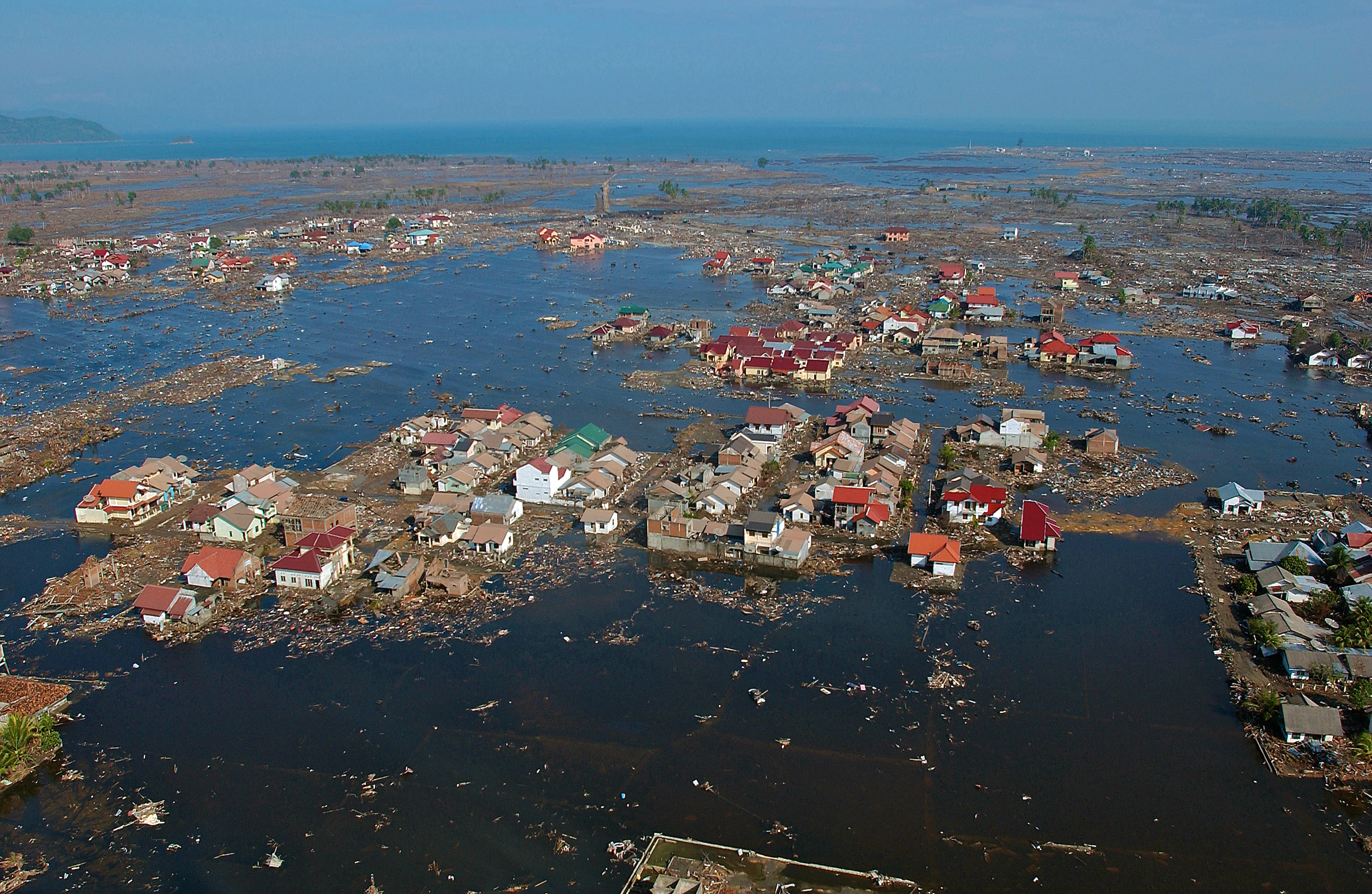 Figure C.1 Inundation, whether by
cyclonic or monsoonal rainfall, or
tsunami, is a characteristic feature of South East Asia and South Asia.
Northern Australia is no less exposed, with numerous instances of
severe cyclone damage, the most prominent being the destruction of
Darwin by Cyclone Tracy in 1974. Depicted Bandar Aceh following the
2004 tsunami (U.S. Air Force).
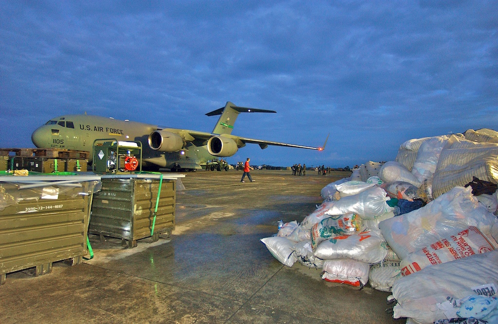 Figure C.2. High operational tempo
airlifts are a characteristic
feature of post disaster rescue and relief operations. Depicted is a US
Air Force C-17A delivering aid materiel into Bandar Aceh following
the 2004 tsunami (U.S. Air Force).
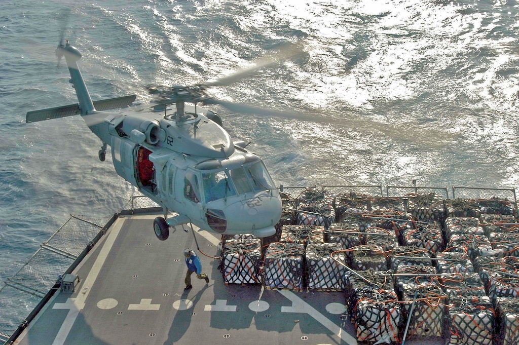 Figure C.3. The ability to sustain
helicopter operations at high operational tempos is invaluable
following natural disasters. Depicted US Navy SH-60 Seahawk helicopter
delivering emergency supplies into Aceh following
the 2004 tsunami (U.S. Navy).
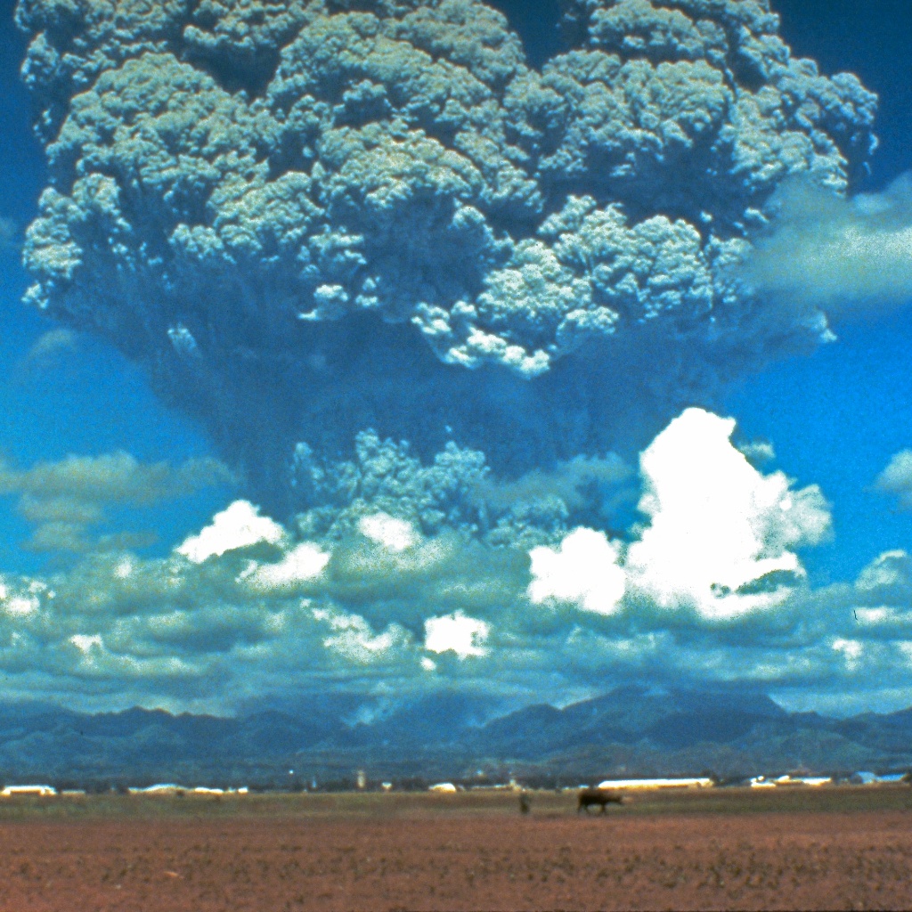 Figure C.4. Volcanic eruptions in
Indonesia
and the Philippines have repeatedly caused loss of life, population
displacement, economic damage and the destruction of infrastructure on
a large scale. The tectonic features of the region are such, that
future volcanic events are certain. Depicted the 1991 eruption of Mount
Pinatubo (USGS).
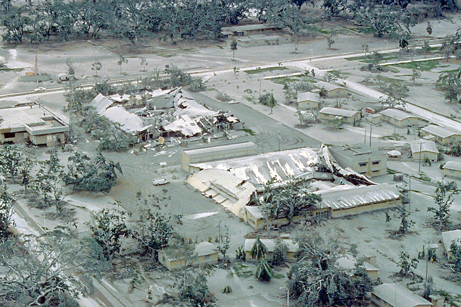 Figure C.5. Volcanic ash clouds
are a
serious hazard to air navigation, but can also produce severe
infrastructure damage, resulting from roof collapses, and blockages of
water management infrastructure. Depicted damage to Clark AFB in the
Philippines following the 1991 eruption of Mount
Pinatubo (USGS).
|
||||||||||||||||||||
Annex D
Examples of Indian Ocean Offshore Territories Fauna
|
||||||||||||||||||||
|
Parts of the Pilbara, Kimberley and Indian
Ocean Offshore Territories remain amongst the great unspoilt wilderness
areas of Australia, and are home to many endemic species, and many more
widespread species which are under severe survival pressure in other
parts of Australia, or the world. This annex contains imagery of some
of the species which are under threat, and two of the introduced
species responsible for severe damage on Christmas Island.
Images of Barrow Island habitats and species, many common to other sites in the Pilbara and Kimberley, can be found at Barrow Island Imagery; other species found in these regions are depicted under Australian Wildlife Images, and local plant species under Western Australian Flora. One often overlooked advantage of expanded military basing in these areas is that within the boundaries of military bases human and animal access can be tightly controlled, and introduced vegetation replaced by the original species, restoring original habitats. |
||||||||||||||||||||
 Figure D.1A,B Green Sea Turtle Chelonia
mydas nesting on Barrow
Island off the Pilbara coast. Several thousand of this endangered
species live in the Cocos
(Keeling) Islands area. Sea turtles are at risk due to hunting in
developing nations, loss of nesting habitats, disease, and collisions
with boats (© 1979 - 2012 Carlo Kopp).
  Figure D.2 The
critically endangered Hawksbill
Turtle Eretmochelys imbricata
(Bruno Navez, Creative
Commons Licence).
 Figure D.3 The endangered endemic Cocos (Keeling) Islands Buff Banded Rail Rallus philippensis is largely confined to North Keeling Island, due to habitat loss and predation in the atoll islands. Competition with feral domestic chickens and introduced Junglefowl is often a cited cause (Peter Halasz, Creative Commons Licence).  Figure D.4 The
abundant and endemic Christmas
Island
terrestrial Red Crab Gecarcoidea natalis has suffered a claimed 30%
population loss
due to invasive pest species, primarily the Yellow Crazy Ant
Anoplolepis
gracilipes. The Red Crab is a critical component of the local
rainforest ecosystem and its loss presents as an “ecological cascade
failure”, where loss of a species produces cascading damage effects
across the habitat (Jarich / Rebecca
Dominguez, Creative
Commons
Licence).
 Figure D.5 Christmas
Island is claimed to
host the
world's largest single population of the terrestrial Coconut crab
Birgus latro, which can grow to a weight in excess of 4 kg, and has
a claimed lifespan in excess of sixty years.
While the
species is widespread across the Indo-Pacific islands, including the
Cocos (Keeling) Islands, it is hunted by
humans and uncommon in populated areas. On Christmas Island it is
seriously threatened by the Yellow Crazy Ant.
This example was photographed in 2006 on Christmas Island
(Jarich / Rebecca Dominguez, Creative
Commons Licence).
 Figure D.6 The introduced Yellow Crazy Ant, Anoplolepis gracilipes, is a problem species across the north of Australia, but has produced devastating environmental damage on Christmas Island (USGS).  Figure D.7 The predatory Giant Centipede, Ethmostigmus rubripes, was introduced to Christmas Island from the mainland and has produced serious damage (John Hill, , Creative Commons Licence). |
||||||||||||||||||||
|
Air Power Australia Analyses ISSN 1832-2433 |
||||||||||||||||||||
|
|
||||||||||||||||||||
|
|||||||||||||
|
|
|
|
|
|
|
|
||||||
|
|
|
|
|
|
|
|
||||||
 [Click for more ...]") |
|||||||||||||
| Artwork, graphic design, layout and text © 2004 - 2014 Carlo Kopp; Text © 2004 - 2014 Peter Goon; All rights reserved. Recommended browsers. Contact webmaster. Site navigation hints. Current hot topics. | |||||||||||||
|
Site Update
Status:
$Revision: 1.753 $
Site History: Notices
and
Updates / NLA Pandora Archive
|
|||||||||||||
|
|
Tweet | Follow @APA_Updates | |||||||||||
|
|
|||||||||||||
|
|
|||||||||||||


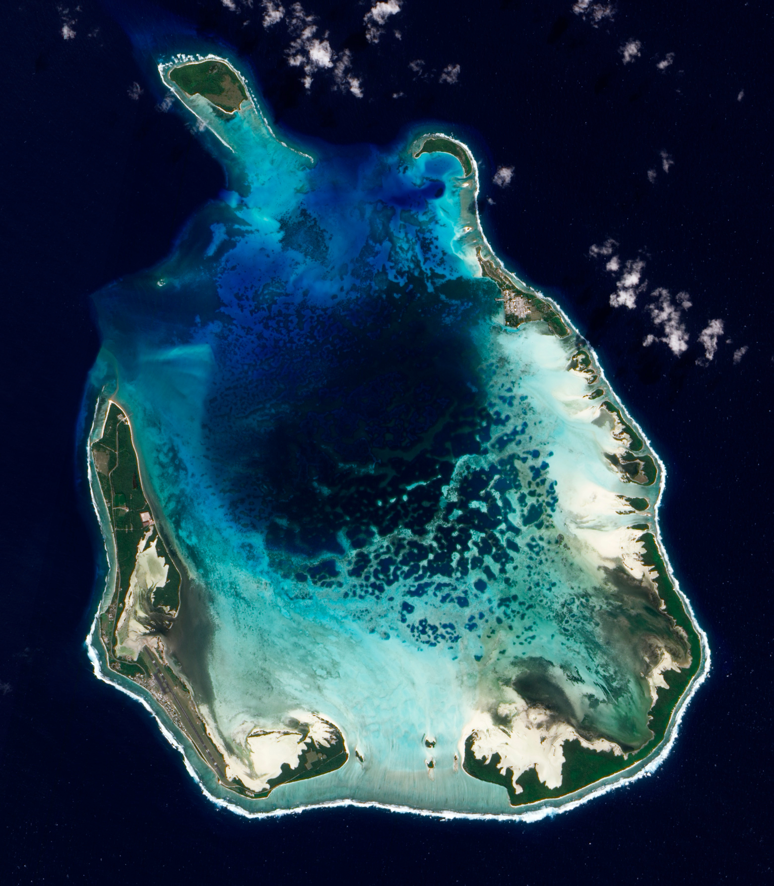
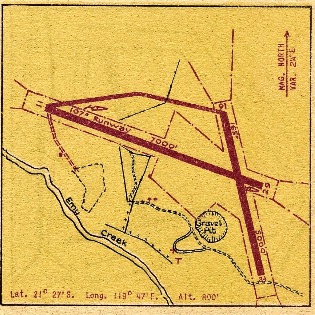
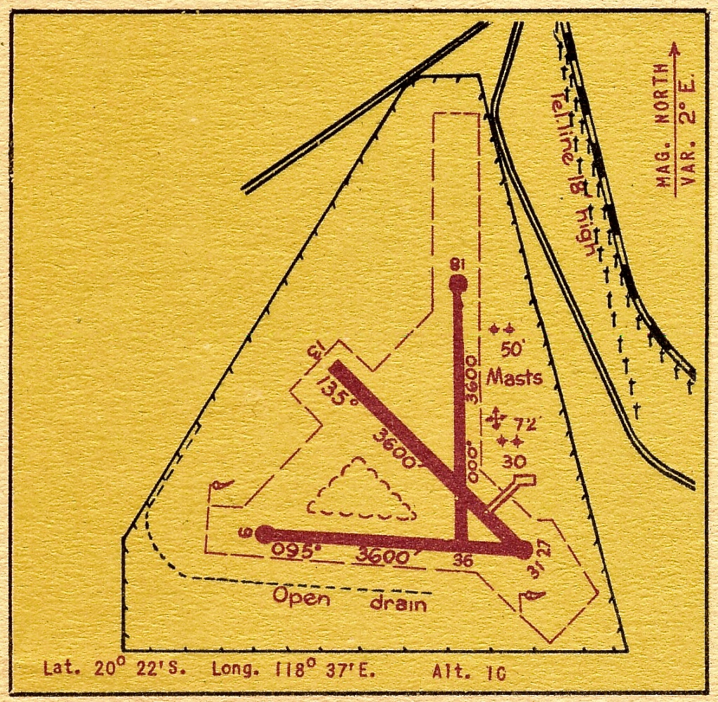
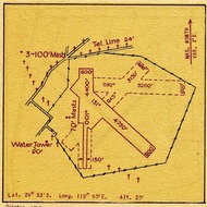
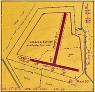

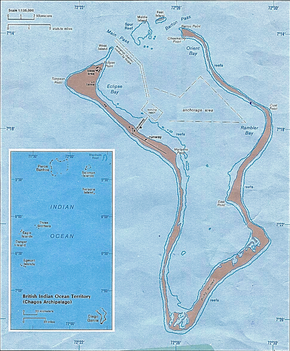
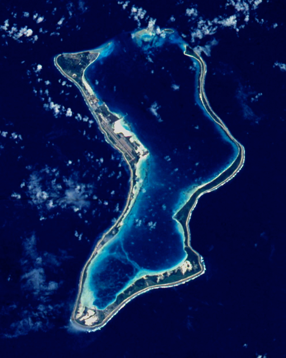
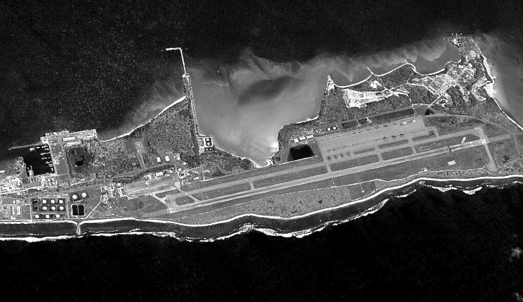

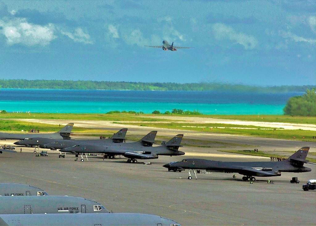
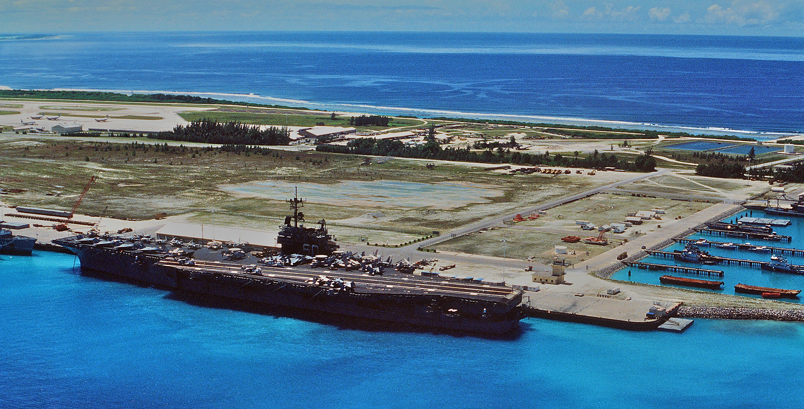
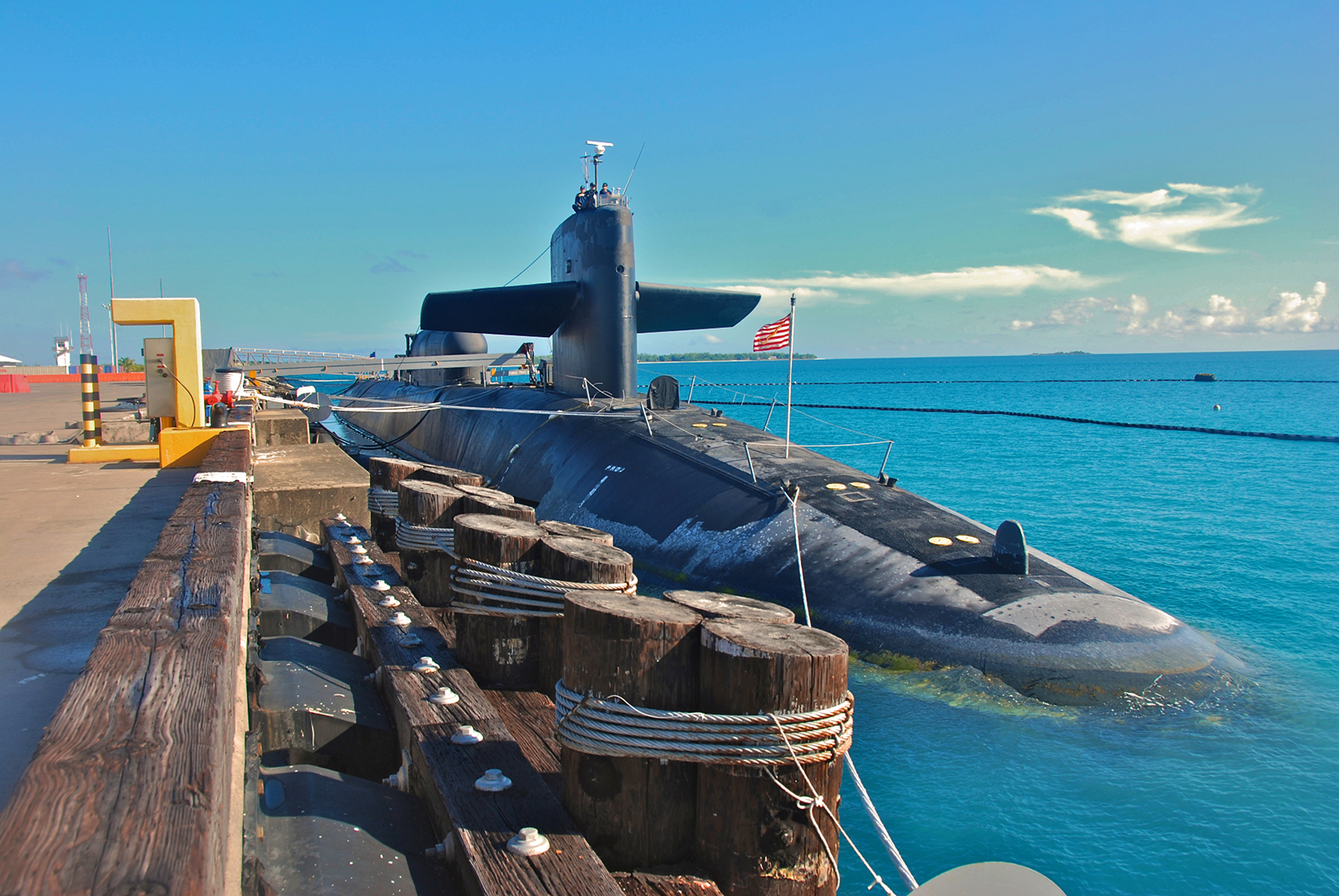