|
||||||||||||||||||||||
 |
||||||||||||||||||||||
 |
 |
 |
 |
 |
 |
 |
 |
|||||||||||||||
 |
 |
 |

|
 |
 |
 |
 |
|||||||||||||||
 [Click for more ...]") |
||||||||||||||||||||||
| Last Updated: Mon Jan 27 11:18:09 UTC 2014 | ||||||||||||||||||||||
|
||||||||||||||||||||||
|
||||||||||||||||||||||
|
||||||||||||||||||||||
|
|
|
|
|
|
|
|
|||||||||||||||
|
|
|
|
|
|
|
|
|||||||||||||||
|
||||||||||||||||||||||
| Last Updated: Mon Jan 27 11:18:09 UTC 2014 | ||||||||||||||||||||||
|
||||||||||||||||||||||
GPS Aided Guided Munitions - Parts I-V |
|||
|
|||
 Block
IIR GPS Satellite Vehicle (US DoD).
|
|||
|
GPS Part I - GPS and DGPS
Navigation
The USAF's NavStar Global Positioning System (GPS) satellite navigation system has taken the world by storm, and together with the Internet is probably one of the best ever examples of dual use military/civilian technologies to emerge in the last decade. GPS promises revolutionary changes in civilian aviation, both in RPT and GA operations, and with the proliferation of Differential GPS (DGPS) will provide accuracies of several feet to its users. What has been less publicised is that GPS is becoming the technological foundation for a new generation of guided munitions, which promise a significant reduction in the cost of hitting point targets under any weather conditions. What has been even less publicised is that GPS will also provide precision weapons capabilities to nations which have historically lacked the ability to hit anything smaller than a football field. To fully appreciate the implications of this technology, we will first take a closer look at the strengths and weaknesses of GPS and Differential GPS, review the principle technical and strategic aspects of GPS munition guidance, speculate on other possible applications for GPS guidance and finally review current GPS based munition programs. NavStar GPS - a Technical Perspective The GPS system traces its origins to the sixties. In 1960, Aerospace Corporation was founded for the purpose of applying then advanced technology to space and ballistic missile problems. In 1963, the company started work on Project 621, the Global Positioning System, a scheme for replacing strategic aircraft astro-navigation systems with satellite navigation. Whereas astro-navigation systems needed clear sky to track stars, the satellite navigation scheme would use microwaves and a satellite distributed master clock, thereby providing all weather operation and superior accuracy. The Operational GPS Constellation uses 24 satellites, of which 3 are spares, orbiting in precise 12 hour orbits. The orbit geometry is adjusted so that these orbits repeat the same ground track once per day, and at any point on the Earth's surface at any given time the same configuration of satellites should be seen. The satellites are grouped, nominally in sets of four, into six orbital planes, each of which is inclined at approximately 55 degrees to the polar plane. A user at any point should be able to see between five and eight satellites at any time. The USAF's constellation of 24 NavStar GPS satellites will revolutionise navigation as we know it, with a wide range of commercial applications as well as its intended military applications. A GPS receiver will measure time of signal propagation from four or more satellites, and use this information to calculate the receiver's position in three axes, using the WGS-84 earth model (Rockwell). The satellites are controlled via a worldwide network of tracking stations, with the Master Control situated at Falcon AFB in Colorado. The Master Control station measures signals from the satellites to incorporate into precise orbital mathematical models, which are then used to compute corrections for the clocks on each satellite. These corrections, and orbital (ephemeris) data are then uploaded to the satellites, which then transmit them to GPS user's receivers. A GPS receiver can then use these signals to compute its geographical coordinates, measure time, and also then calculate velocity. The GPS system provides two navigational services, the military Precise Positioning Service (PPS), and the civilian Standard Positioning Service (SPS). PPS provides nominally 17.8 m horizontal accuracy, 27.7 m vertical accuracy and time accurate to 100 nanoseconds. SPS provides nominally 100 m horizontal accuracy, 156 m vertical accuracy and time accurate to 167 nanoseconds, and is available to civilian users. The degraded accuracy results from the use of Selective Availability. In practice, achieved accuracy can significantly better the nominal figures. The GPS constellation transmits two microwave (D band) carrier signals, L1 at 1.57542 GHz and L2 at 1.2276 GHz. The L1 carrier is modulated with the Coarse/Acquisition (C/A) code and Navigation Message, used for PPS and SPS, and the military P-code, used for PPS only. The L2 carrier is modulated only with the military P-code. The central idea behind GPS is that of precisely measuring range to several satellites, the positions of which are known. It is then possible to calculate the position of the receiver. The simplest geometrical model to use is the the sphere model - knowing the range to any given satellite places the receiver on the surface of a sphere centred upon the satellite, with a radius equal to the measured range. Knowing the range to two satellites places the receiver on the curve where the two respective spheres intersect. Knowing the range to a third satellite places the receiver at the intersection point common to all three spheres. In practice, however, a fourth range measurement to yet another satellite will be required to compensate for the inaccuracy in the receiver's clock. The result is a set of equations, which if solved yield the position of the receiver and the time. GPS Signals, Messages and Error Sources Whilst the basic idea behind GPS is straightforward, implementation becomes somewhat more complex. Both carriers are modulated in phase (conceptually similar to FM radio) with Pseudo-Random Noise (PRN) codes. The C/A code is a 1023 bit 1 MHz PRN code which is unique for each satellite, and is used by military receivers to acquire and lock on to the P-code, whilst in civilian receivers it is the navigational reference signal. The military P-code is a seven day repetition cycle 10 MHz PRN modulation which is imposed upon both the L1 and L2 carriers. It is usually encrypted to P(Y) code, and can only be used if the user has both a military GPS receiver as well as the classified key to decode it with. The P-code modulation on the L2 carrier is used by military PPS receivers to measure ionospheric transmission delays. The third code, the Navigation Message, is a 50 bits/s digital signal which contains six second duration frames comprised of five 300 bit subframes of data. The Navigation Message is broadcast by each satellite. It contains encoded clock corrections, precise orbital data, correction parameters for an ionospheric model, and Almanacs, which describe approximate satellite orbital data over extended periods of time. A receiver will extract this data from the NM signal, and use it to correct its clock to within 100 (PPS) or 167 (SPS) nanoseconds of UTC time, as well as to calibrate its internal model for the satellite orbit, and its internal model for ionospheric delays. The C/A and P-codes are used for measuring range to each respective satellite. A receiver will use an internal PRN code generator to produce a PRN code for each of the satellites. This code is then compared to the received satellite signals using a circuit termed a correlator, and if the PRN codes match, the receiver can lock on to the satellite to measure range. When a receiver's PRN code generator is in lockstep with the satellite's transmitted PRN code, the time at which the repeating PRN code starts is extracted. This time is termed the Time Of Arrival (TOA), and the difference between the TOA and receiver internal time, adjusted for the offset between receiver time and GPS network time, is a measure of the distance to the satellite. The range thus calculated is termed Pseudo-Range. 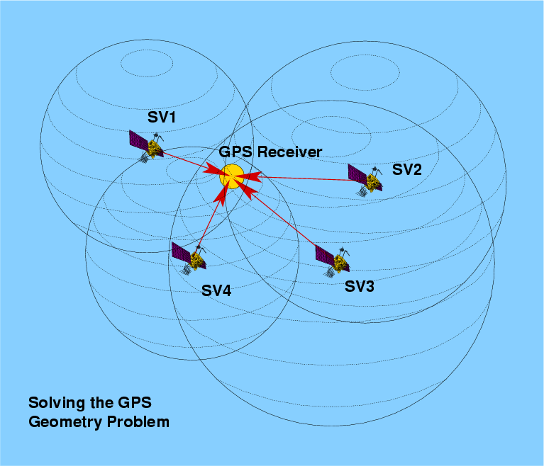 A GPS receiver will use the four or more Pseudo-Range measurements to compute position in Earth-Centred, Earth-Fixed (ECEF XYZ) coordinates. These are then converted by the receiver into geodetic latitude, longitude and height above the surface of an ellipsoid (the Earth isn't round after all!), typically using the WGS-84 Earth model, although other models may be used. As the GPS system assumes the WGS-84 model, use of other models without correction can produce significant positioning errors. GPS receivers can measure platform velocity by differencing consecutive position measurements, or by measuring the Doppler of satellite carrier signals and using this with computed direction to each satellite, to calculate velocity in three axes (like aircraft Doppler Nav inside out). Some receivers may use both methods to improve accuracy. There are a number of error sources in GPS navigation. Electrical noise in the receiver, a well as phase noise in the PRN code modulation will degrade accuracy by about 2 metres. Each satellite uses four atomic clocks (two cesium and two rubidium) which are highly accurate, but drift in time nevertheless. If satellite clock errors are not corrected by the ground station, this will degrade accuracy by about one metre. Errors in orbital position estimation will also lose about one metre. As well unmodelled signal propagation delays in the troposphere, due changes in humidity, temperature and pressure changing the refractive index, will lose about one metre. Multipath,the effect of satellite signals bouncing off obstacles and arriving from several directions each with different time delays, will degrade accuracy by about 0.5 metre. The biggest single natural source of error is unmodelled ionospheric signal delay, the model broadcast by the satellites can only compensate for about one half of the possible error, with the resulting error being up to 10 metres. In addition, another effect comes into play, Geometrical Dilution Of Precision (GDOP). Where the angles to the satellites in view are very similar, GDOP will result in inaccuracy in solving the coordinate equation, which will further degrade the solution. Because all of these sources of error will fluctuate in time, users may experience substantially better accuracy at some times, and worse accuracy at other times, depending on the geometry of the satellites in view and ionospheric conditions (the latter a Jindalee problem as well). Non-military users will also experience an artificially produced error, resulting from Selective Availability. The SA mechanism introduces a time varying bias in the C/A signal, which is designed such that it is virtually impossible to remove. The potential C/A code accuracy of at least 30 metres is thus reduced to the nominal 100 metres. GPS Receivers With a system as complex as GPS there are a multiplicity of ways in which a receiver can be built, and this results in a wide range of achieved accuracies and costs across receiver types. The simplest receivers are single channel receivers, which time share a single channel of receiver hardware across the satellites in view. Whilst this saves in hardware costs, it is slow and as a result such receivers do not usually deliver spectacular performance, and are usually ill suited to fast moving platforms such as aircraft. Most high performance receivers today are five channel receivers, which dedicate a channel of receiver path and correlator hardware to each of the five or more satellites they are tracking. Such receivers can also accommodate platform motion more readily, indeed most airborne military receivers use at least five channels. A typical strategy used in a five channel receiver is for four channels to track satellites, and one to hunt for the next satellite to come into view, so that there is no loss in continuity when switching one of the four channels (eg the IEC SEM-E receiver tracks five, the Collins GEM-III receiver tracks four with a fifth hunting). High cost, high performance military receivers may use up to eight channels to provide best possible accuracy when eight satellites are in view. Typical receivers will use an antenna, a frequency downconverter and receiver hardware. Antennas come in all shapes, sizes and levels of performance. The usual requirement is for upper hemispherical omnidirectional coverage, and antennas will use schemes based upon monopoles, dipoles, volutes, spiral helices or microstrip patches. Military receivers with directional antennas are becoming popular, as this provides improved resilience against jamming and interference.  The key to success is affordability, and affordability is very much a function of complexity. This Rockwell 5-channel commercial GPS receiver fits on a 4 x 2.5 in. printed circuit board, with all receiver functions performed by the chipset on the board. Because GPS receivers are built from mass producible electronic components, they can be relatively cheap, and this is vitally important in both commercial and munition guidance applications (Rockwell). 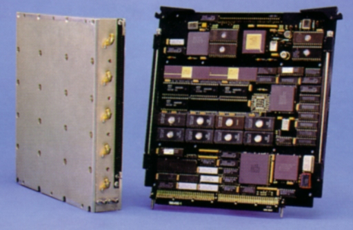 The Magnavox MX-8000 Anti-jam GPS Receiver (AGR) was specifically designed for operation in heavily jammed environments, and was to be used in the cancelled Northrop AGM-137 TSSAM missile. This receiver uses adaptive nulling techniques to suppress jammers, and beam steering to boost the satellite signal. The receiver will acquire a GPS signal with a 70 dB Jam/Signal ratio (jam power 10,000,000 times higher than GPS signal) and once acquired, track a GPS signal with a 100 dB Jam/Signal ratio (jam power 10,000,000,000 times higher than GPS signal). It is worth comparing the complexity of this receiver with the simplicity of commercial receivers, which are highly susceptible to interference and hostile jamming (Hughes-Magnavox). 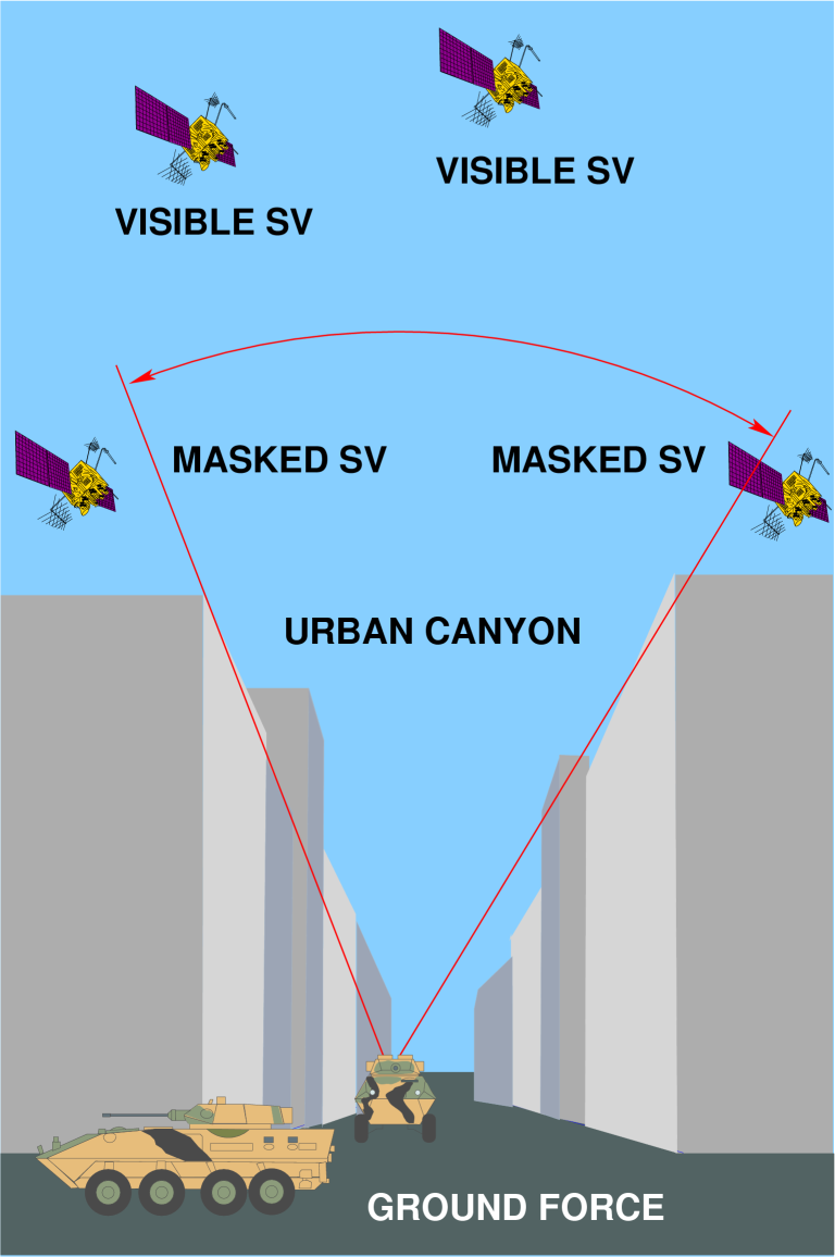 The Urban Canyon
problem (Author).
GPS Vulnerabilities and Countering Them For all of its technological splendour, GPS has its weaknesses. The principal of these is the low power level radiated by the satellites, which introduces vulnerability to both interference and jamming. The power level to be detected by a GPS receiver is -160 dBm (decibels wrt one milliWatt, or 10 exp -19 Watts), which is by radio broadcast standards miniscule. A USAF source acknowledged that this was about 1/1000 the received power from a small FM broadcast station. In practice, this vulnerability has been observed in some parts of the US, where GPS signals have been jammed by harmonic interference from commercial TV stations, operating in the VHF band, and mobile telephone transceiver towers, operating in the UHF band. Even the small amounts of energy leaking from these transmissions into the 1.5 GHz band were found to produce volumes of space, miles across, where airborne GPS receivers were unable to maintain lock and dropped out. This produced much debate in the US, and as a result GPS reception performance will be monitored across the country to determine which radio transmitters may be interfering. These would then be assigned to different channels and frequencies. In the military context, this vulnerability is a major concern and has produced some heated debate in the US trade press. Even low powered jammers radiating pseudo-noise signals against the GPS carriers could cause typical receivers to either break lock, or fail to acquire satellites from distances of tens of miles. A one Watt transmitter (comparable to a mobile phone) at a distance of 60 km (32 NMI) can in theory prevent a common GPS receiver from acquiring the C/A code. Military receivers locked on to the encrypted P(Y) code are more resilient, and cca 100 W of jam power at 20 km (10.7 NMI) is required to break lock. Significantly, a jammer radiating hundreds of Watts can foil satellite C/A code acquisition at ranges of several hundred nautical miles. The Saddams of this world could potentially disrupt attacks by weapons using many current generation receivers by hoisting such jammers to several thousand feet altitude on devices as simple as tethered balloons. There are a number of Electronic Counter CounterMeasures (ECCM) which may be used to improve the resilience of GPS receivers to jamming. The first technique is the use of Controlled Reception Pattern Antennas (CRPA), which can electronically form antenna beams in the direction of satellites, thereby boosting the signal relative to the jammer signal. This typically improves Signal/Jammer power ratios by 30 dB (1000 x). Further improvement can be provided by adding a Nuller to the receiver antenna. A Nuller will suppress antenna sensitivity in the direction of a detected jammer, and this will together with CRPA beamforming techniques provide a 50 dB improvement in resilience against jamming. If the receiver is locked on to the P(Y) PPS code, and uses these techniques, jamming power levels of hundreds of kiloWatts at several miles of distances will be required to break lock. It is worth noting that the RAAF's Rockwell MAGR GPS five channel receiver being fitted to the F-111 uses CRPA techniques, unlike many other military receivers currently in use. The USAF has at least two test programs under way to develop intelligent nulling GPS antenna technology. Differential GPS Systems Systematic GPS errors as well as the unavailability of GPS P-code to civilian users was seen as a challenge by many in the civilian technical community, and given the potential commercial payoff in using GPS to its full potential, it did not take very long for techniques to be developed to defeat the Selective Availability of the GPS system. The central idea behind all Differential GPS schemes is that of broadcasting an error signal which tells a GPS receiver what the difference is between the receiver's calculated position and actual position. The GPS error signal can be most easily produced by siting a GPS receiver at a known surveyed location, and by comparing the received GPS position with the known actual position. The difference in positions will be very close to the actual error seen by a receiver in the geographical vicinity of the beacon broadcasting the error signal. In reality, the successful implementation of DGPS requires somewhat greater sophistication than merely broadcasting differences in absolute position coordinates. This is because an airborne receiver may be tracking a different set of satellites, as well as being in a different position and thus experiencing a different GDOP error. To deal with these problems, DGPS stations will track all satellites in view and calculate corrections for the pseudorange measurements to each and every satellite. This allows compensation for the SA bias error and well as the systematic errors in the pseudorange measurement, particularly ionospheric delays. A DGPS receiver will then apply the correction factors to the pseudorange measurements its uses to generate its navigation solution. The broadcast updates must be several seconds apart to defeat both SA and other error sources. Differential GPS schemes thus require a beacon to broadcast the local GPS error signal, as well as an airborne GPS receiver which can decode the broadcast, extract the error signal, and apply it to the position estimate which it has derived from the GPS constellation. Accuracies achieved by civilian C/A based DGPS have been as good as 1-3 metres, which has led to their application to areas such as Cat III Instrument condition approaches and landings. This level of accuracy is also more than adequate for the precision guidance of munitions, and DGPS schemes have thus become an area of major military interest. There are numerous ways in which a DGPS scheme can be implemented. The earliest non-military DGPS applications saw local area beacons implemented by plugging a GPS card into a Personal Computer, wrapping some appropriately written software around it and broadcasting the DGPS error signal on a dedicated VHF radio channel. More sophisticated schemes are of course possible, such as piggybacking the DGPS signal on to a VOR beacon subcarrier, as well as broadcasting encrypted and coded signals to paying or authorised users only. The US FAA is currently looking at the implementation of the Wide Area Augmentation System (WAAS), which will see DGPS error signals broadcast over the continental US from geostationary INMARSAT satellites. Aircraft with suitable receivers will thus be able to exploit both wide area and local DGPS schemes to get the best possible positional accuracy. The USAF have been decidedly unhappy about this development, as they invested US$21 billion into developing and deploying the NavStar constellation, and expend US$600 million yearly to run it, only to have what they perceive to be civilian freeloaders exploit their system and defeat the built in safeguards against hostile use. As things stand, the deployment of the FAA's WAAS will allow anybody with a suitable commercial DGPS receiver to achieve blind bombing accuracies well in excess of what is provided by basic PPS P-code whilst in US airspace. This is a nightmare for the USAF, responsible for defending US airspace, as the deployment of DGPS will very quickly lead to a virtual complete dependency of the civilian ATC and traffic management system upon DGPS. The option of shutting down the WAAS system, as well as local DGPS beacons would become extremely difficult, even in wartime, as the civilian infrastructure ever cost conscious will have dismantled much of its existing base of older navaids such as VOR/DMEs and NDBs. Even should much of the VOR/DME/NDB infrastructure remain in place and functional, the next issue to contend with is civilian pilot currency. The ease of using GPS/DGPS will see a steady erosion of the skills base and currency in the usage of conventional navaids. Thus shutting down the high accuracy component of the civilian GPS infrastructure would introduce serious operational hazards, certainly until the flying population regains its currency. The collapse of the VOR/DME/NDB infrastructure in the US will exacerbate this, as the Americans have become very spoilt with the density of navaids in the US. In this respect Australia should look very carefully at what fraction of the existing navaid infrastructure is dismantled with the introduction of GPS. The military dimension to DGPS is of particular interest, both from an offensive as well as a defensive perspective. The SRI developed wide area DGPS network used for the USAF EDGE project trials (Part 3) demonstrated accuracies within 0.5 metres. The accuracy of DGPS allows both blind bombing and munition guidance with accuracies very similar to that achieved by using laser or TV guided bombs. Given the availability of a DGPS error signal, aircraft nav attack systems become pinpoint accurate under all weather conditions. Because wide area DGPS beacons can be effective for hundreds of miles, an air force can position beacons within the theatre of operations and provide all suitably equipped aircraft within range of the beacon with DGPS updates. For deep penetration of hostile airspace, beacons which can be interrogated in burst mode by satellites could be planted in hostile territory by special forces, at presurveyed locations. Such beacons could be built to transmit encrypted position readings using low probability of intercept techniques (LPI) to avoid discovery, the interrogating satellite could then broadcast the derived error signal to penetrating aircraft. What is even more important, is that GPS guided weapons can be fed DGPS derived positions prior to release from an aircraft, and should their flight time be relatively short, very little positional error will be accumulated enroute to the target. Many existing munitions, eg the BGM-109 Block III Tomahawk and the AGM-130/GBU-15 already exploit P-code GPS to improve the accuracy of the inertial midcourse guidance. Adding DGPS corrections will significantly improve the positioning accuracy of the weapon prior to transitioning to terminal guidance. To extend this model further, an aircraft could transmit via datalink both DGPS corrections as well as the updated position of a moving target to a weapon in flight, which would use these to adjust its aimpoint on the way to the target.  The RAAF's AUP Program will see the F/RF-111C fitted with a highly accurate 5 channel Rockwell MAGR GPS receiver, to provide precision velocity and position updates for the aircraft's dual RLG INS equipment. This will provide a significant improvement in the aircraft's accuracy, particularly over long distances. The MAGR receiver employs beam steering techniques for coping with jammed environments. The task of equipping an aircraft to receive one or another form of DGPS signal update is not difficult, all that is required is a suitable beacon or datalink receiver with a Mil-Std-1553B bus interface, and a modification to the mission computer navigation software. Ideally, the receiver would be designed to accept DGPS signal broadcasts from civilian satellites (eg WAAS), local DGPS beacons, military satellites and UHF datalinks. This would also allow the receiver to identify intentional spoofing, as well as defeat jamming of any of the DGPS channels. Furthermore, the accuracy of DGPS has spawned a new generation of all weather munitions which will rely wholly upon DGPS/GPS for their midcourse and terminal guidance. How these work will be the subject of Part 2 of this feature. Acknowledgments: Special thanks to Dr Don Kelly then of the USAF EDGE Program for his review of the draft of this article. Additional Reading:
|
|||
|
GPS Part II - GPS and DGPS Munition Guidance
The
availability of GPS and highly accurate Differential GPS navigational
aids has created a revolution in aircraft navigation. What is less
commonly known is that GPS and DGPS are about to transform what we
understand to be the nature of precision bombing. Indeed, the
introduction of GPS and DGPS guided munitions will have an impact not
unlike the introduction of laser guided bombs, with the resulting force
multiplication effects significantly improving the potency of Western
air forces as a strategic power projection tool.
GPS Guided Munitions The central idea behind the design of DGPS/GPS/inertial guided weapons is that of using a 3-axis gyro/accelerometer package as an inertial reference for the weapon's autopilot, and correcting the accumulated drift error in the inertial package by using GPS PPS/P-code. Such weapons are designated as "accurate" munitions as they will offer CEPs (Circular Error Probable) of the order of the accuracy of GPS P-code signals, typically about 40 ft. The next incremental step is then to update the weapon before launch with a DGPS derived position estimate which will allow it to correct its GPS error as it flies to the target, such weapons are designated "precise" and will offer accuracies similar to laser or TV guided weapons, potentially CEPs of several feet. Because the GPS package is highly accurate a cheap inertial package may be used, while the GPS package is inherently cheap to manufacture as it uses wholly electronic hardware which can be built by automated production equipment (robots) used commercially. Providing that the servo mechanisms and weapon airframe are designed for cheap mass production, the DGPS/GPS/inertial guided bomb can be built as cheaply as standard laser guided munitions. Only should an opponent capable of jamming GPS signals be encountered, will more expensive inertial packages and ECCM equipped receivers be required (NB: even so a good military receiver can cost as little as US$5k/unit in volume). For an aircraft to support such
munitions, it will require a DGPS receiver, a GPS receiver and
interfaces on its multiple ejector racks or pylons to download target
and launch point coordinates to the weapons.
The development of purely GPS/inertial guided munitions will produce substantial changes in how air warfare is conducted. A GPS/inertial guided weapon which is updated with DGPS corrected position will, if properly designed, offer accuracy only slightly lesser than a proportionally guided laser guided weapon or TV guided weapon. Unlike a laser guided weapon, a GPS/inertial weapon does not require that the launch aircraft remain in the vicinity of the target to illuminate it for guidance - GPS/inertial weapons are true fire-and-forget weapons which once released, are wholly autonomous and all weather capable with no degradation in accuracy. Existing precision weapons require an unobscured line of sight between the weapon and the target for the optical guidance to work. GPS/inertial weapons are oblivious to the effects of weather, allowing a target to be engaged at the time of the attacker's choosing. 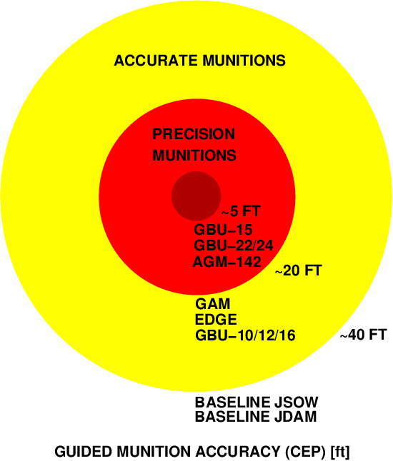 The impending deployment of GPS guided bombs and glidebombs will revolutionise air warfare as we know it. Affordable, all weather attack on multiple targets by single aircraft will become the norm. This diagram depicts the relative accuracies of established laser and imaging optical weapons, against the published performance figures for the first generation of GPS and DGPS guided weapons (Author). From a tactical perspective, this removes many of the traditional constraints which forced delivering aircraft to have to penetrate through defences to guide a weapon - standoff launches become virtually the standard for this family of weapons. What is even more significant, is that the traditional constraint of laser guidance, illumination for each target/bomb, no longer exists. An aircraft can program its whole load of weapons each for individual targets, release these from standoff range almost concurrently, and then immediately egress the target area. As well, weather over the target is no longer an operational constraint. The ability to concurrently attack multiple targets with a single aircraft from standoff ranges is an unprecedented force multiplier for air power as an offensive tool. Providing that an aircraft can penetrate to launch range, it can then saturate target defences with its whole payload of weapons, which if not engaged by point air defences, will destroy their programmed targets autonomously. Consider the scenario of an F-111 attacking an air defence radar site with laser guided bombs. To approach undetected it will have to penetrate at low altitude, and then toss the one or two bombs delivered at the target and illuminate to bomb impact. This profile exposes the aircraft to "trash fire", ie AAA, small arms and shoulder launched SAMs while at low level in the vicinity of the target, as well as being fuel inefficient and imposing fatigue load upon the airframe. While a soft target like an air defence radar could be easily destroyed by a 500 lb weapon, maximising the probability of kill would dictate the use of a pair of 2,000 lb weapons to ensure that either bomb guidance errors or operator tracking errors do not compromise the kill - reattacking a target is much more expensive than using a pair of bigger bombs. 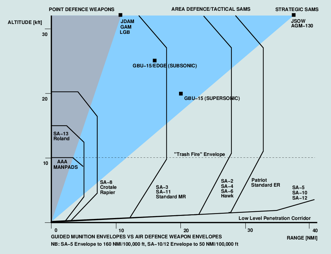 This diagram depicts the envelopes of some
commonly used air defence weapons, against the envelopes of established
guided munitions and the new GPS guided munitions. Significantly, the
combination of GPS and glidebomb technology defeats most air defence
weapons completely, while offering this capability in weapons which may
cost $100k or less. This diagram includes recently published figures
for
subtypes of the SA-10 Grumble missile (Author).
Consider now the same target being attacked with DGPS/GPS/inertial guided bombs. The F-111 could fly an indirect approach to the target at medium altitude and much higher TAS, and when approaching the limits of area defence SAM coverage, rapidly accelerate to supersonic speed, quickly change heading toward the target, and toss its payload of eight 500 lb GPS/inertial guided bombs for maximum standoff range. Several of these bombs could be programmed to hit the primary target, but others could be programmed to hit the command vans, point defence SAM systems and AAA batteries surrounding the radar van. In this tactical scenario, the single aircraft has inflicted the same damage as a multiple aircraft strike, whilst also having minimised exposure to all threats other than fighters. For an unpowered weapon, standoff range is maximised by launch altitude and airspeed, and weapon glide performance. An example profile is the 48th TFW's GBU-15 attack on the heavily defended Al Ahmadi oil pumping stations during the Gulf War. The F-111F aircraft approached the coastal target at supersonic speed at 20,000 ft and launched the weapons from about 20 NMI distance, they then immediately turned away and guided the GBU-15s to impact through datalink commands. Were the aircraft delivering GPS/inertial guided weapons, they could have immediately left the target area at supersonic speed to frustrate any potential interceptor threat. Whereas the Al Ahmadi strike required two aircraft to take turns at hitting two targets, requiring loiter in the vicinity of the target, and this inviting a fighter attack with any competent opponent, the use of GPS/inertial guided glidebombs would have simplified the sortie quite significantly as a single aircraft could engage both targets with a single pass. The ideal weapon for this style of air attack is a highly aerodynamically efficient glide-bomb which allows a supersonic toss delivery - this allows the launch aircraft to impart the maximum amount of energy to the weapon during launch and thus maximise standoff range. Ranges of 40-70 NMI become quite feasible, and this will defeat most area defence SAM systems. As the aircraft is supersonic at high altitude, it will be a difficult target for an interceptor, moreso since it will not need to loiter. Because the weapon is unpowered, it is substantially cheaper to buy and to maintain than a powered weapon, and expensive datalink pods or laser targeting equipment are no longer required. Where the aircraft is stealthy, the defence's warning time may be non existent. In any event the task of engaging a 900 kt target at 30,000 ft will be extremely difficult for a Combat Air Patrol, and even more difficult for a ground launched interceptor. 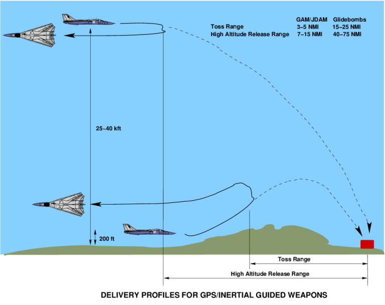 The GPS guided glidebomb allows the single bomber to reclaim the upper portion of the penetration envelope. As these weapons can be released from above 30,000 ft at transonic speeds, and glide for up to 75 NMI, they allow a bomber to engage its target from ranges where SAMs are wholly ineffective, and fighter CAPs are hard pressed to perform without AEW and tanker support. This provides a significant advantage to the attacker, who can saturate defences with multiple weapons (Author). The model postulated here assumes the air defence system is functional, however should it become subjected to intense radar and communications jamming and direct attack, and should fighters be available to threaten the defending interceptors, this profile becomes both highly survivable and very dollar efficient, particularly in a low air defence density environment such as the Asia-Pacific. In any event, this approach defeats all AAA and point defence SAM systems, which are a plague during low level operations. Another factor which falls out of this paradigm of air attack is that electronic combat operations can defeat the air defence system by taking out only the strategic early warning, strategic SAM acquisition and Ground Control Intercept radars, the economically costly process of lobbing Anti-Radiation Missiles (ARM) against every SAM and AAA system fire control and acquisition radar becomes largely redundant. Once the long range early warning, strategic and interceptor control radars are down, the air defence system is in dire straits. The need to saturate the lower tiers of the system with suppressive ARM fire, cluster bombs and jamming is no longer required in order to close to weapon release distance. The availability of a GPS/inertial guided cluster munition, and a highly accurate rangefinding radar warning receiver (ie 0.1 degrees DF accuracy/0.2% range accuracy) would allow the suppression of most area defence SAM radars without having to expend expensive Anti-Radiation Missiles, only the most capable and expensive systems such as the S-300 (SA-10/12) would require ARMs for suppression. With a powered munition providing 50 NMI of range, even systems such as the S-300 would become ineffective. Because such SAM systems are expensive, large numbers will not be deployed, and not every operator will be competent to use the weapon to its fullest. The GPS/inertial guided weapon is thus a potent force multiplier in strategic air warfare, as it allows single attacking aircraft to engage multiple targets simultaneously, day or night, under all weather conditions, from standoff ranges. This automatically defeats all target point defence systems, and most area defence weapons. This means that an attacking air force only has to deal with strategic air defence weapons and fighters, which can then be dealt with more easily as a larger proportion of resources will be available to defeat them. Because a single aircraft may engage multiple targets on a single sortie, the GPS/inertial guided weapon is a force multiplier on the scale of the laser guided bomb, when first introduced. Whereas before the LGB, it was a case of many aircraft/bombs for one target, the GPS/inertial weapon swings this equation around, with one aircraft for many bombs/targets. In terms of performance parameters for strike capable aircraft, high payload radius and aerodynamic performance becomes a major asset as it allows the best possible exploitation of the capabilities inherent in the GPS/inertial guided munition. As these weapons make high and medium altitude attack more attractive even in the opening phases of an air campaign, the importance of electronic combat capabilities oriented against strategic early warning, GCI and SAM acquisition radar, communications, command and control is increased relative to the importance of defending against tactical and point defence SAMs and AAA. Defensive ECM will need to be reoriented against fighter radars, air-air missile seekers, strategic SAMs and early warning radars first and foremost. Opponents unable to field the top tier of air defence weapons will be highly vulnerable to air attack by GPS/inertial guided standoff weapons. In the Australian context, the deployment of cheap GPS/inertial guided weapons will increase the value of the F-111 significantly, as it is the aircraft which can best exploit the capabilities of this family of weapons. The use of such weapons would strongly reinforce the case for upgrading the aircraft with a current generation powerplant, as this would allow supercruise operations which fit this paradigm so nicely. It would also reinforce the case for boom equipped tankers, as this would allow the aircraft to carry a substantial payload of such weapons at radii of thousands of nautical miles (NMI). Importantly, the focus of the upcoming EW upgrade for the F-111 should take this in operational paradigm into account. Targeting GPS Guided Weapons The deployment of DGPS/GPS/inertial weapons will create some interesting problems in the area of targeting. Whereas existing laser and TV guided weapons have an operator in the loop to refine the aimpoint and minimise collateral damage, generic GPS guided weapons are wholly autonomous and their accuracy is determined primarily by the accuracy of the target coordinates loaded before launch. Once released, they are committed and no corrections are possible. Only should the weapons be equipped with a datalink receiver, capable of feeding target position updates into the autopilot during flight, are aimpoint corrections or attacks on moving targets feasible. It is worth noting that a one way datalink of this variety is a technically much simpler proposition than the wideband video datalinks used by TV guided weapons, and hence such a datalink receiver will be much cheaper to build. The use of any GPS/inertial guided weapons will place a premium on the quality of targeting information. Whereas contemporary satellite, aerial and radar reconnaissance can tolerate some inaccuracy as the delivering aircraft can visually acquire the target and correct the aimpoint if required, generic GPS guided weapons must be targeted accurately from the outset. If the reconnaissance picture used for target selection is poorly registered against the maps used, or the maps are inaccurate, this error could not only compromise the attack on the target, but also produce politically problematic collateral damage. A commander who unloads 8,000 lb of GPS guided bombs on infrastructure targets, only to find that a 0.5 mile error in his maps has placed the payload on a baby milk factory or religious or cultural artifact, is likely to be politically crucified if not by his own chain of command, then certainly by the lay media whose appetite for controversial death and destruction footage is insatiable. The technological means of solving this problem exists, but is yet to be widely deployed. It is the high resolution imaging synthetic aperture radar. Such radars have resolutions of about 1 metre, and if tightly calibrated should be capable of locating a target with an accuracy of feet at standoff ranges of tens of nautical miles. As a result, such radar could be used by inbound bombers to confirm the aimpoints perviously programmed into the nav-attack system, before weapon release. Furthermore such radar, if supported by Ground Moving Target Indicator (G-MTI) modes, can locate surface targets of opportunity such as vehicle and armour convoys for subsequent attack. The GATS (GPS Aided Targeting System) on the USAF B-2A is a good example of such a system. 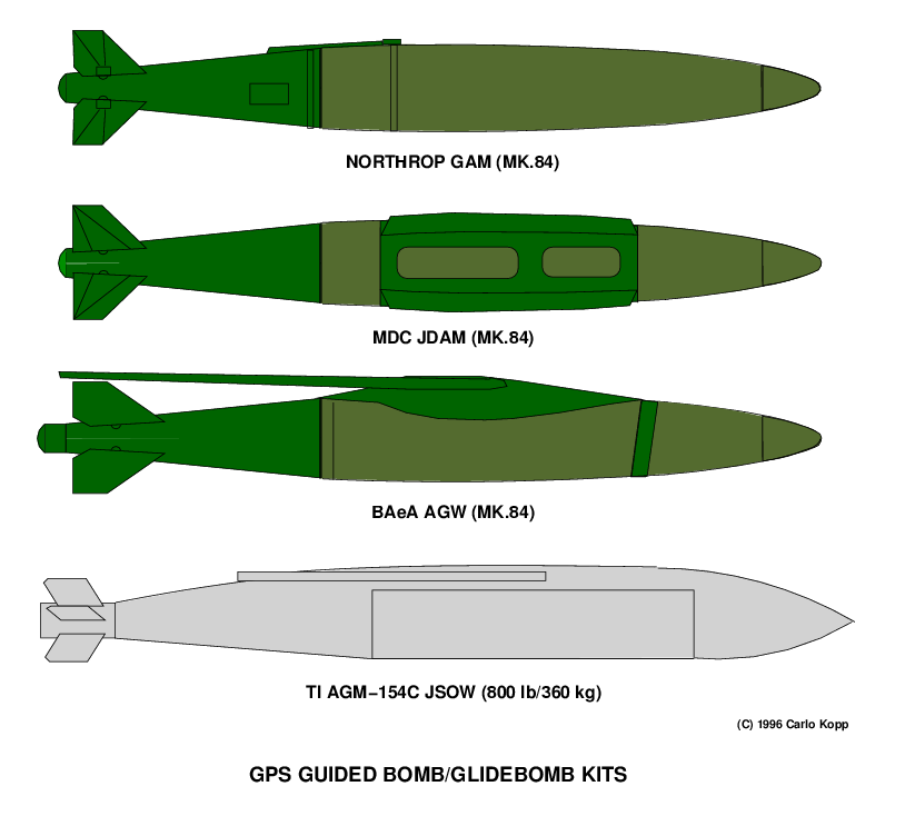 The Texas Instruments AGM-154 JSOW is a USN/USMC/USAF program to provide a 1,000 lb class GPS guided glidebomb. This USN F/A-18 is carrying four such weapons during trials. Upon release these glidebombs deploy their wings and glide to impact over ranges in excess of 40 nautical miles. The JSOW is reviewed in detail in Part 3 of this feature (Texas Instruments). Extending the Paradigm The availability of cheap DGPS/GPS autopilots raises other interesting possibilities. One of these is the "Robot Kamikaze", where retired fighters can be fitted with such autopilots and used as heavyweight cruise missiles or decoys for air defences. As the aircraft are flying a one way trip, their useful range is effectively doubled. A retired 350 NMI mile radius tactical fighter becomes, with one or two 2,000 lb bombs attached, a 700 NMI cruise missile. As the aircraft will have been paid off, the starting cost is zero. Stripping all non-essential equipment items will reduce takeoff weight and improve effective range. The only cost incurred are the GPS autopilot, its interfaces to the flight control system, and installation and testing costs. Ongoing maintenance costs are minimal as the airframe is not flown until needed, and by retaining manual flight controls and minimal instrumentation, the weapon can be ferried to its deployment base. In use, the autopilot could be programmed to route the aircraft around known defences, and then expend remaining fuel in a supersonic afterburning dive against the target. Large targets such as industrial sites and petro-chemical plants would be ideal targets for such weapons, which will add significant incendiary effect to the explosive effect of the payload. Used as decoys in the opening phase of an air campaign, they will draw the fire of the air defence system thus forcing the expenditure of ready rounds on launchers, as well as forcing air defence radars to light up and thus expose themselves to SEAD aircraft, positioned in anticipation of this. Vulnerabilities of GPS/DGPS Guided Weapons - ECM and ECCM Whilst the deployment of DGPS/GPS/inertial guided weapons promises an almost order of magnitude increase in the destructive potential of a suitably equipped air force, it also creates problems to be dealt with. The first is the potential for an opponent with suitable technological skills to jam the satellite signal, thereby degrading weapon accuracy and removing much of what is gained by using the technology. The second problem is that competent opponents may use the same GPS signal to guide their own weapons, thereby acquiring a capability they may not otherwise have. As discussed earlier, there are some reasonably potent electronic counter-counter measures (ECCM/EPM) techniques which can be used to defend against jamming, however it is important that this be accounted for when designing GPS based weapon systems. Failure to do so could create a significant vulnerability. Jamming bombing navaids has a long history and the fate of the Luftwaffe during the Battle of the Beams (Blitz) should be a good reminder of the operational consequences of taking a simpleminded approach to the issue. Hostile Exploitation of GPS Weapon Guidance The more worrisome problem is that of GPS exploitation. Even during the Gulf War it was reported that the Iraqis used commercial GPS equipment to assist in calibrating Scud launch sites. The real problem will come about when Third World countries start dusting off their fifties and sixties technology cruise missiles and fitting them with commercial DGPS/GPS autopilots. Most of these weapons used combinations of inertial autopilot, radio command link and anti-ship radar homing guidance to attack either shipping or area land targets. In the latter instance, they were never taken seriously due their poor accuracy. With DGPS accuracies they become very effective standoff weapons. ") There are some very good examples. The Russians exported large numbers of AS-5 Kelt missiles, as well as ship launched P-21/SS-N-2 Styx missiles. The Chinese reverse engineered the Styx into the air and surface launched HY-2 Silkworm, and its derivatives, the larger HY-4 and C-601. These weapons typically carry 1,000 to 2,000 lb warheads, to ranges between 50 and 100 nautical miles. What is important is that the PRC is still manufacturing the Silkworm family of missiles and these have been very widely exported throughout the Third World. To compound the problem, the CIS (formerly USSR) still has significant stocks of former AV-MF and DA anti-ship cruise missiles which were intended for use against Western shipping convoys in the event of war. The most potent of these is the liquid rocket propelled supersonic 13,000lb 200 NMI range AS-4 Kitchen, which carries a 2,000 lb warhead and was deployed both on the Backfire and Bear G cruise missile carrier. Late Eighties estimates placed the stockpile at about 700 rounds. The AS-4 is supplemented by the AS-6 Kingfish, which is slightly smaller, uses solid rocket propulsion, and has very similar performance and warhead type. Estimates placed the Kingfish stockpile at 300 rounds. With a stockpile of 1,000 rounds and a hyper-inflationary economy, we can have no doubt that the Russians would be most accommodating should a government offer to exchange their collection of boneyard ASMs, or a portion thereof, for hard cash. Equipped with DGPS autopilots these become quite serious weapons which can be very hard to stop either by fighter or SAM. Another concern which has arisen, perhaps overly publicised by Dale Brown's Technothriller "Storming Heaven", is the possibility of terrorists fitting GPS autopilots to GA airframes and using these to attack targets from within the airspace of Western countries. Whilst perhaps somewhat fanciful, this idea should also not be ignored. All is fair in love and war, and the possibility of a Third World government despatching an engineer with a covert penetration group to implement such a scheme is not beyond the realm of possibility. As it appears, the only real defence the Western Alliance will have against hostile GPS exploitation will be that of jamming the GPS SPS C/A code, and equipping Western military aircraft with suitably jam resistant receivers. Civilian aircraft will have to get by with VOR and DME, whilst the L1 carrier is being jammed. The only other alternative would be to encrypt the civilian SPS signal, and distribute keys only to authorised users in wartime situations. Summary The proliferation of GPS and
DGPS guidance is a double edged sword. On the one hand, this technology
promises a revolution in air warfare not seen since the laser guided
bomb, with single bombers being capable of doing the task of multiple
aircraft packages. On the other hand, GPS and DGPS may be exploited by
relatively unsophisticated industrial nations to provide them with a
capability which until now has been the almost exclusive domain of the
Western Alliance. The ease with which basic GPS signals can be jammed
will result in another major cycle of ECM and ECCM development, as
defenders and attackers build jammers and jamproof GPS receivers to
counter jammers. To complete the analysis of this paradigm in air
warfare, Parts 3 and 4 of this feature will review current US GPS and
DGPS weapons development programs.
|
|||
|
GPS Part III - US Direct Attack Munition
Programs
The 1990s are a period of two fundamental paradigm shifts in air warfare. The first of these is stealth, which renders almost any air defence system impotent. The second of these is GPS and Differential GPS guidance of munitions, which promises a force multiplication effect not unlike that seen with the deployment of the Laser Guided Bomb. Whereas the LGB saw the move from many-aircraft/one-target to one-aircraft/one-target, GPS guided weapons will allow a single aircraft carrying multiple bombs to attack and destroy multiple targets on a single pass. The US has been very quick to capitalise on the potential of this technology, and at this time there are no less than four weapons in development, and a major technology demonstration program in progress. The Northrop GAM The Northrop GPS Aided Munition (GAM) kit was devised by Northrop engineers as a means of providing the B-2 bomber with a precision conventional attack capability. The B-2 was initially developed to defeat the Soviet PVO-S IADS in a SIOP nuclear war scenario, using its 40,000 lb payload of SRAM missiles and free fall nuclear devices to hit key strategic targets, as well as carve corridors through defences to allow the conventional B-1B and B-52 to attack other strategic targets. With the demise of the Evil Empire and the shifting bias toward conventional war, the B-2 needed a precision conventional capability, something not achievable by dumping twenty tons of Mk.82. 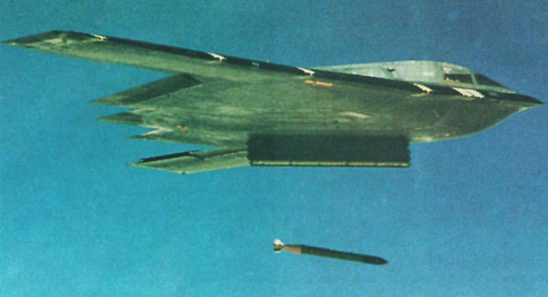 Like a giant bird of prey, the majestic Northrop B-2 releases a Northrop GAM-113 5,000 lb guided bomb. The first of the new generation of GPS guided bombs, the GAM-84 achieved its IOC earlier this year with the first batch of weapons deployed with the Whiteman AFB based 509th Bomb Wing. The GAM is targeted by the aircraft's virtually undetectable Hughes APQ-181 attack radar and associated GATS targeting system, which enable the B-2 to deliver under all weather conditions up to sixteen independent and autonomous 2,000 lb GAMs with accuracies about the same as those achieved by the RAAF's Pave Tack and GBU-10 laser guidance weapon system (Northrop). 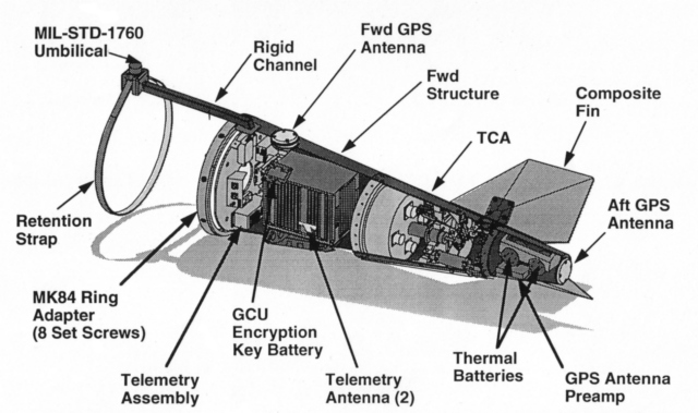 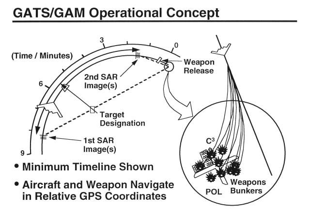 The GAM is the first
GPS/inertial guided munition to be operationally deployed, with the
first batch of weapons achieving operational status earlier this year.
The GAM is often described as an "expensive JDAM", and the weapon owes
its origins in part to early USAF studies and technology demonstrations
under the Inertially Aided Munitions (IAM) program, which determined
the
feasibility of using inertial guidance on a bomb and eventually led to
the JDAM program (described below).
The Mk.84 GAM comprises a 100 lb tailkit which fits into to the standard Mk.84 slick form factor. The tailcone contains a pair of thermal batteries which power the munition, a servo-motor assembly which actuates the four fully movable tailfins, and a guidance system, which comprises a high performance GPS receiver , an inertial package with accelerometers and rate gyros (the same as used in the AIM-120 Amraam), and a computer running the guidance algorithm and autopilot software. Two GPS antennas are used, one dorsal and one at the end of the tailcone, the latter to provide good GPS signal during the terminal phase when the bomb is pointing downward. The interface to the launch aircraft is through a Mil-Std-1760 umbilical, which incorporates the Mil-Std-1553B serial databus and prelaunch power feed. The dorsal umbilical connector feeds through a rigid channel into the tailcone assembly. The GAM has proven to be highly accurate during trials, with better than 20 ft CEPs achieved consistently for launches from 15,000 to 45,000 ft. The reason for this high level of accuracy is the B-2's GPS Aided Targeting System (GATS). The GATS is built around the B-2's Hughes AN/APQ-181 J band phased array Low Probability of Intercept attack radar (a worthy TE topic within itself), which is capable of producing highly accurate focussed Synthetic Aperture Radar (SAR) imagery of a target area as the bomber approaches. The B-2 will attack its target flying a curved trajectory to enable the SAR to generate images. Nine minutes out and with the target cca 45 degrees off boresight, the B-2 will image the target and the copilot/mission commander/navigator/bombardier (all in one) will use crosshairs on his cockpit scope to designate aimpoints for the weapons on the radar map. Ninety seconds off the target, the radar again generates an image and the aimpoint(s) are if necessary refined. The GAMs assigned to the target are then initialised via the 1760 interface with the target coordinates and the constellation of satellites which the bomber's GPS receiver is tracking. The bombs are then released and track to impact. High accuracy is achieved because the bombs see the same satellite constellation the bomber sees, and thus experience almost identical GPS errors to the bomber. The bombs are initialised with an aimpoint relative to the bomber, rather than an absolute set of map coordinates, and the primary errors are then determined by the inaccuracy of the bomb's guidance algorithms and the range/bearing calibration error of the radar. This scheme is very clever and a tribute to Northrop and Hughes' engineers. The standard GAM is built around a Mk.84 blast fragmentation warhead. Experience from the Gulf however indicated that standard 2,000 lb bombs were ineffective against deeply buried bunkers, this leading to the hurried development, deployment and use of the laser guided GBU-28 and the BLU-113 4,500 lb penetration casing warhead (the USAF executed this project in less than 30 days). This warhead was clearly a candidate for GPS guidance and Northrop engineers adapted the existing GAM design to fit the weapon. The 4,700 lb (2,130 kg) 202" (5.13 m) long BLU-113 GAM uses a modified GAM tailkit with an adaptor fairing, extended 1760 umbilical and autopilot software changes. As well the weapon has a cruciform wing assembly to improve lift and thus both range and manoeuvre performance, the latter contributing to accuracy. The B-2 will carry up to 16 2,000 lb Mk.84 GAMs or a much smaller number of BLU-113 GAMs, the latter presumably carried on a modified rotary launcher. While the ability to carry in effect four F-111 loads of precision weapons at intercontinental ranges under any weather conditions is impressive within itself, the ability to engage targets with total surprise and virtual impunity makes the B-2/GATS/GAM the most potent conventional bombing capability in existence today. The BLU-113 provides the further capability to attack hardened and buried targets such as key command posts and nuclear, biological and chemical weapons storage sites. Northrop have made the interesting observation that a single B-2 with 16 GAMs has the equivalent capability to a pair of B-52s delivering 32 cruise missiles, with a total munition cost of USD 640k (USD 40k/round) vs USD 32M for the ALCMs. Whilst the exact figures in this scenario can be debated, it does provide an excellent order of magnitude indication of the force multiplication provided by combining stealth and GPS guided weapons. It is clearly the way of the future. The McDonnell Douglas GBU-31/32 Joint Direct Attack Munition The JDAM program is the direct offspring of the eighties IAM program. Whilst IAM initially sought to improve the accuracy of tossed unguided weapons, the incorporation of GPS into the concept improves accuracy to a point where is compares very well with less accurate types of laser guided munitions. This concept was validated by the USAF's Operational Concept Demonstration (OCD), an end-to-end demonstration of INS/GPS guidance including targeting, weapon development, and flight test. OCD proved conclusively that the JDAM concept was a low technical risk and ready for accelerated development, leading to early deployment. 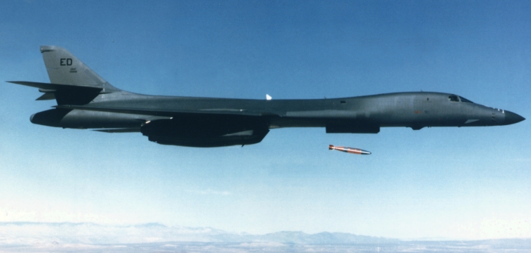 This Rockwell B-1B is releasing a single 2,000 lb MDC GBU-31 JDAM round. The B-1B is a good illustration of the paradigm happening through GPS guided bomb technology, as the aircraft can deliver up to 24 2,000 lb JDAMs from its rotary launchers, or up to 84 500 lb Rockwell BVUD or JDAM derivative rounds from bomb racks. Each weapon is autonomous and can be independently targeted, giving true meaning to the description of "one aircraft - many targets". With the deployment of the GAM and JDAM on the B-2 and B-1B, the USAF has acquired an awesome conventional strategic strike capability with no historical parallel. The strategic bomber is now truly carrying its weight (McDonnell Douglas). The JDAM development was then
initiated in the early nineties, when Gulf war experience indicated the
need for an all weather accurate or precision munition. Poor weather
conditions on many occasions compromised sorties armed with laser
guided
weapons and an alternative was sought to arm USAF, USN and USMC strike
aircraft.
The baseline JDAM program provides a design for the GBU-31/Mk.84 and BLU-109 2,000 lb weapons and the GBU-32/Mk.83 and BLU-110 1,000 lb weapons for use on the USAF F-15E, F-16C, F-117A, F-22, B-1B, B-2A and B-52H, the USN F-18C/D F-14A/B/D and the USMC AV-8B and F-18C/D. The baseline accuracy for the weapon is a CEP of 42 ft (13 m) with a target volume production cost between USD 14k and 25k/round, which is highly competitive with laser guided weapons. Martin-Marietta (prior to merger with Lockheed) and MDC competed for the lucrative contract, with MDC winning the eventual prize. 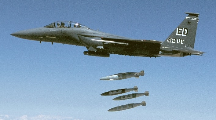 The GBU-31 and GBU-32 JDAM are an unprecedented force multiplier when deployed on tactical fighters. Existing laser and datalink guided bombs require that the aircraft illuminate the target until bomb impact and maintain line of sight to the target. The JDAM may be tossed or released from high altitude, and each weapon released will autonomously find its target with no operator intervention under any weather conditions. This significantly improves fighter survivability, as well as improving performance and reliability as the heavy and complex laser designator equipment need not be carried. Aircraft such as the late model F-18E and F-15E with imaging synthetic aperture radars can engage targets of opportunity with high accuracy (McDonnell Douglas).  The USAF's JDAM Product Improvement Program (PIP) is currently in requirements definition and is evaluating concepts for increased accuracy, improved anti-jam capability, increased range, and compatibility with various warheads, including several small, highly lethal warheads under development by the USAF's Wright Laboratory in Florida. The "small bombs" are intended to provide aircraft such as the F-22 and JSF (formerly JAST) with a credible strike capability using internally carried weapons. US industry sources suggest that JDAM accuracy improvement may involve the use of a millimetric wave radar seeker, which would employ SAR techniques and terrain contour matching to achieve precision delivery accuracy. Whether this is required, given the availability of Scene Matching Area Correlation algorithms and existing millimetric wave seekers such as that used on the BAe Merlin mortar round, is clearly open to debate. In any event, a number of techniques exist for using miniature radar seekers to refine the bomb's aimpoint. The MDC JDAM kit comprises a tail kit and a set of cruciform body strakes, pairs of which are shipped to a deployment site in a hermetically sealed, stratified polyethylene bags inside foam lined fibreglass shipping container. On site the kits are attached to warheads and loaded on aircraft. The shelf life of the sealed package is 20 years and maintenance is not required. The weapon is compatible with the standard US AERO-51, MHU-141, MHU-191 and MJ-40 bomb trailers/hoists.  The strakes on the JDAM increase the body lift of the weapon (cf Standard SAM) and thus contribute to better manoeuvrability and accuracy, as well as a slight gain in delivery range against a standard bomb. The tailkit structure is low cost sheetmetal, and comprises the tailcone, the cruciform fins, three of which are moveable and one fixed, and the guidance package. The latter consists of a tail actuator package with three servoes, a GPS antenna, a thermal battery and Guidance and Control Unit (GCU). The GCU contains an inertial package (IMU), GPS receiver, mission computer, and electrical power conditioner. The weapon uses a Mil-Std-1760 interface, although other alternatives could be supported with appropriate hardware and software interfaces. 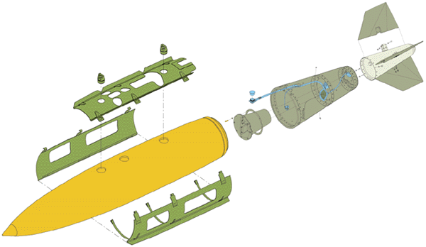 Part 4 will complete our series on GPS aided weapons and address the Joint Stand Off Weapon (JSOW) and other emerging US GPS aided weapon programs. Acknowledgments: Special thanks to Dr Don Kelly then of the
USAF EDGE Program, and Lt.Col. Greg Teman of the USAF JDAM Program
Office for their reviews and comment on the draft of this article.
|
|||
|
GPS
Part IV - US Direct and Indirect Attack Munition Programs
The MDC GBU-31/32 JDAM Continued ... USAF mission planning will use the existing AFMSS/TAMPS software tools which would be used to program a data transfer cartridge with weapon delivery parameters for upload into the launch aircraft's mission computer. Once the aircraft approaches the target area, the JDAM is powered up using aircraft electrical power. With power applied, the JDAM will execute an internal self test, warm up and align its IMU, and download target data from the launch aircraft. The aircraft computer, using an appropriate protocol, talks to the bomb and downloads GPS timing, Almanac (ie nav message), Ephemeris (constellation) and PPS crypto key to initialise the GPS receiver. Once the GPS is initialised, the computer downloads target coordinates, fuse settings, impact parameters. These can be reloaded at any time prior to release. Once the targeting data is loaded, the computer downloads IMU position and velocity data from the aircraft. The weapon is then ready for release. The weapon's guidance control laws provide for both steep and shallow dive trajectories to attack both horizontal and vertical targets, and allow an aircraft to release several independently targeted JDAMs from a single point in space, each of which can fly a unique trajectory type. When the weapon is released, the thermal battery is fired, the JDAM acquires a self-determined, optimum satellite constellation, and flies itself autonomously to impact. The JDAM delivery envelope is identical to that of the dumb Mk.84, Mk.83 and BLU-109 bombs. The weapon can be delivered from up to 50 kft, at speeds of up to 1.3 Mach, using direct (boresight) and off axis trajectories. Accuracy has not been disclosed but will depend critically upon the launch aircraft's capability. A system such as the B-2 GATS would provide JDAM with similar accuracy to the Northrop GAM. Planned JDAM Early Operational Capability (EOC) for B-2 is 1997 and IOC for the weapon is cca 1997. It is expected to be used extensively by all three US services and US allies. The long term intent is to replace the Paveway family of weapons with JDAM. Carried by fighters such as the F-15E and F-18E, which have APG-70 series radars with synthetic aperture high resolution imaging capability (The B-2 APQ-181 shares much hardware and software with these fighter radars) the JDAM can be expected to achieve similar accuracies to the Northrop GAM if similar delivery techniques to the B-2 GATS scheme are used. Aircraft equipped with older and less capable radars will be limited to the weapon's basic CEP. In the Australian context, the JDAM is a viable weapon for internal carriage on the F-111. As the weapon has a similar form factor and ballistic properties as the Mk.84, which is smaller and lighter than the USAF SRAM and B-series "special" devices which the F-111 was designed to carry, carriage is feasible. The existing AUP aircraft design however has wing pylon decoder boxes mounted on the sides of the weapon bay, where they protrude into the space which would be occupied by the bombs. Weapon station decoders are conventionally fitted in the wing pylons, the AUP arrangement was done at the time to avoid the costs of a pylon rework and associated flight test program. To carry the JDAM internally it will therefore be necessary for the RAAF to relocate the pylon decoders either into the wing pylons or along the aft roof of the weapon bay (the latter a technically much simpler process, but requiring clearance from the stowed Pave Tack pod and bomb tails), put the original MAU-12 ejectors back into the weapon bay, add a pair of decoders for the weapon bay stations and make some appropriate wiring, connector and software alterations. It must be argued that now is the appropriate time to do this, as few aircraft have been upgraded as yet and the changes are significantly cheaper to do now than refitting all 22 airframes in 2002. In defence of the RAAF's existing weapon bay usage, it must be stated that at the time of the AUP project definition the JDAM did not exist even on paper and laser guided bombs using Pave Tack were expected to be the only precision direct attack munitions to be used over the life of the aircraft, which is now expected to extend to 2020. Hopefully the RAAF will act on this matter soon as the long term savings outweigh the short term inconvenience. Paveways may not be as affordable or available in 2005 as production winds down and Paveway stocks are expended or timexed. Regardless of the utility of the JDAM when used with the F-111C AUP, this weapon is the cheapest and most practical means of providing the F-111G with an off the shelf precision strike capability. The F-111G does not have a Pave Tack capability, but it does have a usable internal weapon bay with MAU-12 ejectors. Published USAF tables indicate that the aircraft could carry up to six SRAMs or B-series weapons, all similar in size and weight to the GBU-31 2,000 lb JDAM. Subject to clearance testing and stores control support to initialise the weapon (see AA July 96), the F-111G could carry either four JDAMs externally, two JDAMs internally or up to six JDAMs in total. This would allow the RAAF to truly get its money's worth from the additional airframes, at a minimal cost. The Rockwell Mk.82 GPS guided Tailkit The USAF has nearly 100 B-1B aircraft in service, and these are now assigned to perform both conventional and nuclear missions. In the conventional strategic strike role, the aircraft can at this time only deliver either Mk.82 or Mk.84 dumb bombs, the former off bomb racks and the latter off a rotary launcher. USAF ACC were unhappy with this limitation and contracted Rockwell to design a new bomb rack to support ten 1,000 lb cluster bombs rather than 28 Mk.82. A further contract has been let to provide support for the Wind Correct Munitions Dispenser (WCMD), an inertially guided cluster bomb. Clearly impressed with the B-2 GAM/GATS program, the USAF is seeking a similar capability for the B-1B and USD 15M has been allocated to modify two aircraft and supply 200 weapons by late 1997. The USAF at the time of writing were yet to decide whether to tender for the supply, or award the contract directly to Rockwell. MDC are offering a Mk.82 compatible JDAM derivative, using existing JDAM guidance in a smaller tailcone. The B-1B is expected to carry 24 2,000 lb GBU-31 JDAMs on rotary launchers when the weapon becomes available in 2000, the planned Block D avionic upgrade will include support for JDAM. Three JDAMs were successfully test dropped from a B-1B earlier this year. Rockwell have offered the USAF a GPS/inertial tailkit for the Mk.82, which is designated the Mk.82 GT (GPS-guided Tailkit). The Mk.82 GT uses an infrared transceiver on each bomb rather than a Mil-Std-1760 bus interface (the test program accordingly designated the BVUD or B-1 Virtual Umbilical Demonstration). The Rockwell offer involves 5,000 Mk.82 GT kits at USD 15k/round, and the modification of six bombers to carry up to 84 rounds. The Mk.82 GT is like the JDAM, a compact tailkit assembly (see photo) which allows the weapon to be carried in place of the standard dumb Mk.82. Rockwell's press release indicates that the weapon will also be offered for use on other aircraft types, where it will compete with MDC's planned Mk.82 JDAM version. The development program lasted 18 months from concept definition, and a live weapon was tested in a 25,000 ft altitude drop from a B-1B at the China Lake test range. Rockwell have stated that the weapon's achieved test performance exceeded the intended goal for the test drop (we can presume this refers to accuracy). Production rounds are expected to become available for deployment in 1997. 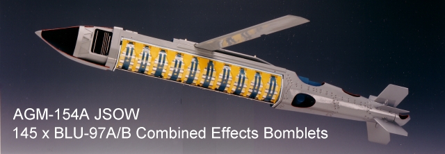 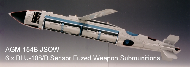  AGM-154A/B/C Variants (Texas Instruments images) The Texas Instruments AGM-154 Joint Stand Off Weapon The JSOW glide weapon is the most sophisticated, complex and expensive member of the new family of weapons planned for US deployment. It is intended to equip the USAF F-15E, F-16C, F-111F (again before its early retirement), F-117A, B-1B and B-2A, and the USN/USMC F/A-18C/E and AV-8B aircraft. The JSOW, like the BAeA AGW, is an offspring of the USN Advanced Interdiction Weapon System (AIWS) program. The AIWS was conceived to plug a hole in existing capabilities as well as to replace the obsolescent post-Vietnam era Walleye glidebomb. The primary role of the weapon is to enable indirect attack against vehicular, air defence and other soft or semi-hard targets from outside the range of point air defences, with a lethality similar to that provided by cluster weapons such as the Rockeye and APAM, and with high accuracy. The initial AIWS requirement was for a weapon compatible with existing USN air assets and the now dead A-12 Avenger II, with a stand-off range in excess of 5 NMI, cluster warhead and inertial guidance. The design was constrained in size by the AV-8B which needed a 1,000 lb class weapon, as well the diversity of target types quickly led TI's designers to look at variants with different warhead types. The current design has provisions to support USN, USMC and NATO launchers, and is built for a gross weight of up to 1,500 lb. In 1992 the USAF bought into the AIWS program, which was then redesignated the JSOW and became a tri-service program with the USN the lead service. The JSOW is a modular weapon and four variants are currently in the pipeline. All variants share the basic airframe and navigation guidance system, but differ in payloads and in some instances, a seeker will be added. The intent was to produce a reconfigurable "bomb truck". The nucleus of the JSOW navigation/guidance is a mission computer package with a pair of Milspec Intel 486 33 MHz CPUs, a Singer Kearfott inertial package and a GPS receiver. Power to the guidance systems and Lucas Aerospace control actuators is provided by Eagle Pitcher thermal batteries. The weapon is programmed through a Mil-Std-1760 or 1553B interface much like a JDAM. The JSOW design will provide a standoff range of 15 NMI for a low level release, and 40 NMI for a high altitude release. The weapon can turn through 180 degrees to engage off boresight targets. Moreover, the smarts provided by two fast CPUs allow the weapon to perform some very clever tricks. On release the weapon will separate laterally from the launch aircraft, before it deploys its wings and commences its glide, to ensure safe clearance. Once programmed, as long as it is released at such an altitude and range to be able to aerodynamically reach its target, it will autonomously calculate the flightpath and profile to correctly engage its target. If released at high speeds, it will delay wing deployment to avoid penalising its range by drag, the wing is deployed when most appropriate. The weapon can also be programmed to attack a target from a specific heading, and to fly between multiple programmed waypoints. A typical profile will see the weapon glide in at several hundred feet, pop up close to the target and dive in to dispense its payload from several hundred feet. The first variant of the weapon is the AGM-154A, termed the baseline JSOW. This weapon is intended for use against soft targets such as parked aircraft, vehicles, SAM sites and mobile command posts, and for close support of troops on the deck. It carries 145 BLU-97A/B Combined Effects Bomblets (CEB), a munition which was used in cluster bombs during the Gulf campaign and was very popular with its USAF users. Each CEB has a conical shaped charge which can punch through 5 to 7" or armour, a main charge which produces about 300 high velocity fragments, and a Zirconium sponge incendiary element. The CEBs are deployed in a dive, the JSOW uses pyrotechnic charges to blow off the payload bay doors, after which a gas generator inflates an internal aluminium bladder which breaks a set of retaining straps and ejects the CEB payload. The second variant of the JSOW is the AGM-154B. This variant is a specialised anti-armour weapon, which carries six sticks of Sensor Fused Weapon (SFW) submunitions. The SFW is the production derivative of the Skeet weapon developed for the original DARPA Assault Breaker program (Tacit Blue, Pave Mover, JSTARS see AA Sept 1984). Each SFW stick is retarded by drogue chute on release, upon which it fires a solid rocket which via canted nozzles spins the device to a high RPM whilst converting its descent into a climb. At this point the four skeet submunitions are released in a clover leaf pattern. Shaped like ice hockey pucks, and unbalanced so they wobble as they fly, the Skeets each have a simple two colour infrared sensor which searches for a tank signature using the wobble to produce a classical conical scan pattern. Once the Skeet detects a tank, it fires its shaped charge warhead which propels a metal pellet formed from the Skeet body (termed a self forging penetrator) through the soft top armour of the victim tank. The JSOW's intelligent navigation system allows it to be programmed to follow a road and dispense the SFW sticks at programmed aimpoints, accounting for wind and weapon velocity. Planned USAF improvements to the SFW submunition will include a better infrared sensor and a warhead which will produce a slug and a shrapnel pattern. The third variant of the JSOW is the AGM-154C, intended specifically to replace the USN Walleye glidebomb. This variant carries a 500 lb BLU-111 Mk.82 blast fragmentation warhead, and a thermal imaging terminal seeker and datalink. The datalink is compatible with the Walleye AWW-13 pod, and allows the operator to select an aimpoint for weapon impact. TI are proposing an autonomous version. The fourth variant of the JSOW is proposed but at the time of writing not funded for production. This subtype is the powered JSOW, which is equipped with a Williams International turbojet powerplant common to the BQM-74 drone and offers in excess of 120 NMI of standoff range. The weapon aerodynamics were successfully proven in 1995 flight trials and the design has been offered for the RAF CASOM and US JASSM requirements. The basic navigation system can be programmed with 14 waypoints, and provides for throttle control. The weapon would carry a 500 or 800 lb warhead, and use an autonomous or datalink imaging seeker derived from the design used for the cancelled Northrop AGM-137 TSSAM weapon. US reports indicate that despite its complexity, the JSOW program has been very successful to date and an IOC well before 2000 is expected for the baseline variant. From the Australian perspective, the weapon is potentially useful but due existing policy which discourages the use of cluster munitions, is unlikely to be a candidate for deployment. Should policy on cluster warheads change, then the weapon could be a useful tool for defence suppression and interdiction tasks. Summary Australia should not fall behind in the GPS weapons game, the payoff in exploiting GPS is simply too lucrative to ignore. By the same token, Australia should look very hard at how it exploits the technology, and ensure that any GPS based weapons acquired are sufficiently resilient to Electronic CounterMeasures to prevent jamming from compromising what has been gained. As the JDAM is expected to wholly displace the Paveway in US service during the first decade of the next century, the RAAF will have to look very carefully at what direct attack bread and butter munitions it plans to use on the F-111 and F/A-18 in this period. The JDAM may well find itself in service by default. A follow on TE will address the USAF EDGE wide area differential GPS demonstration program, which has yielded some very impressive results, including positioning errors over wide areas of well below 1 metre. Acknowledgments: Special thanks to Dr Don Kelly then of the USAF EDGE Program, the USAF JDAM Program Office and Texas Instruments for their reviews and comment on the draft of this article. 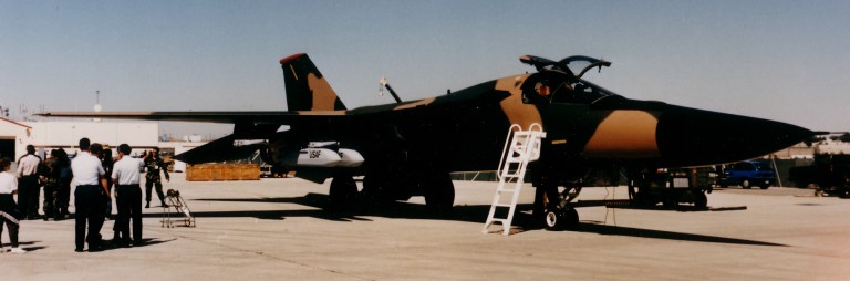 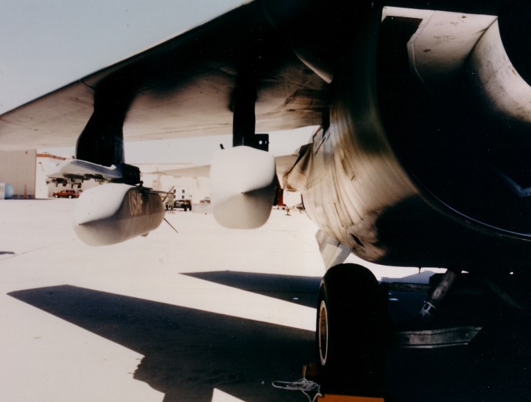 The 1,065 lb TI AGM-154 is an autonomous gliding "bomb truck", built in a number of variants for use by tactical fighters and strategic bombers. The munition's intelligence is provided by a pair of Intel 486 CPUs, which enable it to be programmed with aimpoints, waypoints, delivery profiles and energy management algorithms. The baseline AGM-154A dispenses 145 BLU-97 Combined Effects Munitions, the anti-armour AGM-154B deploys 24 Skeet Sensor Fused Weapon submunitions, while the AGM-154C carries a 500 lb BLU-111 warhead and datalink in the USN subtype. A lightweight weapon built to defeat point defences, the JSOW can be carried one per hardpoint, as illustrated by the depicted F-111 and F/A-18, or in pairs on multiple ejectors for a total of eight rounds on an F-111 (Texas Instruments).  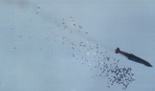 This AGM-154A JSOW is releasing its payload of 145 Combined Effects Bomblets, each of which has an armour penetrating, fragmentation and incendiary element. The AGM-154A "baseline" JSOW is intended for use against soft skinned targets such as vehicles, parked aircraft, SAM sites and radars, command posts and personnel. The weapon will be used by the USAF, USN and USMC on a wide range of aircraft, and allows targets to be engaged from outside the range of point defence and many lower performance area defence missiles (Texas Instruments). Image not available The Rockwell Mk.82 GT is a low cost 500 lb class GPS aided munition which has been proposed for the USAF's B-1B force. Unlike its larger cousins, which employ Mil-Std-1760 bus umbilical interfaces for prelaunch initialisation, the Mk.82 GT employs an infrared transceiver using similar technology to cordless keyboards. This significantly reduces the costs of fitting a bomb bay for guided weapons. The B-1B has a total capacity, within its three voluminous bomb bays, or no less that 84 500 lb Mk.82 bombs. Providing these with accurate guidance means that the B-1B is likely to supplant the B-52 as the USAF's "sledgehammer" heavy bombing capability. |
|||
|
GPS Part V - The USAF EDGE High Gear Program
Australian Aviation, 1997
Last
year Technology Explained
provided a comprehensive four part discussion of the new generation of
GPS guided munitions, and their implications for air warfare in the
next
two decades. In this follow-up article, we will take a look at a very
important technology demonstration program, which was sponsored by the
USAF's JDAM program office.
The purpose of the EDGE (Exploitation of DGPS for Guidance Enhancement) High Gear program was to demonstrate the military potential of wide area differential GPS techniques for weapon guidance, by achieving accuracies better than 3 metres. The program was a stunning success, yielding what should be regarded as remarkable results. The EDGE program demonstrated that appropriate use of DGPS techniques can provide military aircraft and munitions with sub-metre positioning accuracies in all three axes, over areas of continental sizes. How this was achieved will be the subject of this article. The EDGE Program The USAF EDGE Program resulted from a series of Concept Exploration Studies which were sponsored by the JDAM program office. The purpose of these studies was to determine alternatives for providing the JDAM with a 3 metre CEP under adverse weather conditions. The baseline JDAM CEP is 13 metres, which places the weapon into the category of "accurate" rather than "precision" munitions. While an "accurate" JDAM is clearly a weapon of tremendous utility, a "precision" JDAM would allow the weapon to wholly supplant the existing Paveway II/III with an all weather fully autonomous replacement. Existing expectations are that 80,000 JDAM kits will be built. While the JDAM is expected to become the principal all weather "bread and butter" munition for US services, it is not expected to wholly replace all seeker equipped weapons. This is because seeker equipped weapons, using millimetric wave, optical and Synthetic Aperture Radar techniques are becoming more cost competitive, and can operate even in environments where a sophisticated GPS jamming threat or poor GPS reception exist. Moreover, autonomous seeker equipped weapons can achieve high accuracies often with limited support from a launch aircraft. We can therefore expect that the US munitions inventory early in the next century will comprise mainly JDAMs, supplemented by seeker equipped weapons, to provide the diversity to deal with a wide range of delivery platforms, conditions and jamming threat environments. Four studies were contracted for, and these focussed primarily on precision seekers for the JDAM, requirements being that the techniques are cheap, autonomous, allow for retargeting in flight and are all weather capable. One of these studies, conducted by SRI International of Menlo Park, California (formerly Stanford Research Institute), identified the potential of Wide Area DGPS (WADGPS) techniques to fulfill this requirement. The USAF subsequently contracted SRI to conduct a proof of concept experiment. This experiment involved the testing of DGPS over a long (ie 2000 NMI) baseline (ie Florida to California), and then led to the construction of a four station WADGPS network, termed the EDGE Reference Receiver Network (RRN). Following the testing of the network, a number of GBU-15 glidebombs were modified for DGPS/inertial guidance and successfully tested at Eglin AFB in Florida, the USAF's equivalent to our ARDU. The EDGE RRN The best starting point for a discussion of the EDGE RRN are the limitations of the existing GPS scheme and commercial DGPS schemes. Readers unfamiliar with GPS are advised to review the GPS fundamentals covered in the 1996 series. There are three basic sources of error when delivering any munition, these are the target location error (TLE), navigation errors and guidance errors. In a GPS based system, the navigation error is produced primarily by three mechanisms, which are uncompensated atmospheric transmission delays in the satellite signals, errors in the satellite's onboard atomic clock and orbital ephemeris data transmissions, and GPS receiver errors caused by noise and multipath. If we are using the civilian GPS SPS, then a further error is produced by satellite clock "dithering", which intentionally limits accuracy. These errors appear in the pseudo-range measurement to each of the satellites in view and carry through to the navigation coordinates produced. The conventional commercial DGPS schemes in use provide a "band-aid" fix to compensate for dither and atmospheric delays, and satellite orbital and clock errors by measuring pseudo-ranges to satellites from a precisely surveyed location, and using these to calculate a correction which is broadcast to aircraft by a radio beacon. To defeat (Selective Availability) clock dithering, the updates must be as frequent as one per second, to preserve satellite visibility relationships between the ground station and GPS user, the coverage is typically limited to about 300 NMI. A number of commercial DGPS schemes exist which use dedicated radio datalinks, and one which piggybacks the DGPS signal on to commercial FM radio transmissions. The latter is accurate to 1 metre at 75 NMI. Military DGPS schemes can be somewhat more robust, jam resistance is inherently better with P-code systems, dither is not an issue and the receivers can further compensate ionospheric delays by comparing the L1 and L2 GPS carrier signals. Tropospheric delays can be reduced by using error models embedded in the GPS receiver firmware. At a minimum a military DGPS scheme need only compensate for satellite clock offset error and orbital position drift. As a result, a military DGPS scheme can cover wide areas and use fairly sedate update rates as slow as 1 update per 30-45 minutes. The optimal solution for military WADGPS is to add the corrections to the existing GPS navigation message broadcast, however due to limitations of the existing satellites and their supporting ground network this is not a practical short term proposition. The USAF's follow-on and separate WAGE (Wide Area GPS Enhancement) program has demonstrated the insertion of encrypted DGPS corrections into Page 4 of the GPS broadcast almanac message, and has been used for trials of the Block II CALCM and a modified AGM-130. It is intended that the WAGE system eventually transition to an operational system, as the existing GPS satellites are replaced. In the near term, any operationally deployed military WADGPS schemes will have to employ radio datalinks for this purpose, as were used in the EDGE program. In the longer term, late model GPS IIR "replenishment" satellites, which employ satellite-to-satellite radio crosslinks, as well as a higher baseline accuracy of 6 metres rather than 20 metres, and a higher power output for weather penetration and jam resistance, would be used. These will have the capability to robustly support a fully embedded WADGPS scheme such as WAGE. The twenty one GPS IIR sats will be progressively deployed between 1996 and 2006. The datalink scheme used in the EDGE program comprised the USN developed Improved Data Modem (IDM), fitted to the F-16D test aircraft and the central ground station. An encrypted 64 byte correction message included satellite IDs, pseudorange corrections for 12 satellites, standard deviations for corrections and the orbital parameters (specifically data used to select the exact ephemeris pages from the respective GPS almanacs) used in generating the correction. This message was broadcast from the ground station to the test aircraft, decrypted on receipt, and used to improve the accuracy of the aircraft's GPS aided inertial navigation system. Orbital parameters (specifically ephemeris parameters from applicable GPS almanacs) and corrected aircraft position were then downloaded via the Mil-Std-1553B bus to the test munitions. The EDGE RRN evolved from the long baseline WADGPS experiment, and included further design enhancements by SRI to enhance its accuracy. The network employed four ground stations, each no less than 1000 NM from the intended test range at Eglin in Florida. The stations were placed at Kirtland AFB in New Mexico, Ellsworth AFB in South Dakota, Hanscom AFB in Massachusetts and Roosevelt Roads NS in Puerto-Rico, at precisely surveyed locations. Each ground station comprised no more than a high quality military 12-channel GPS receiver and choke ring antenna, designed for very low multipath reception, a desktop computer and a modem. Software running on the computer would gather GPS measurements, calculate errors for the site, and via a modem communicate these to a central site. A computer at the central site would then calculate the proper correction values to be broadcast via radio modem for aircraft operating in the test area. While the hardware requirements for the EDGE RRN were clearly trivial, the SRI developed software which calculated the corrections was certainly not. A number of rather clever techniques were used, requiring no less than 40,000 lines of code, to minimise the resulting DGPS error. The first technique used was to compensate for carrier phase slips, which occur when a receiver loses a carrier cycle. This was achieved by integrating carrier phase. Ionospheric delay was compensated by comparing L1 and L2 P-code measurements with the integrated carrier phase, in turn multipath and noise errors were compensated by carrier smoothing. Carrier smoothing involves the continuous integration of the carrier phase with previous measurements. Thermal drift in the GPS receivers was compensated by placing them in temperature controlled enclosures. Once these errors were compensated, tropospheric delays were measured by long baseline techniques. Tropospheric delays fall into two categories, a "dry" delay due to pathlength (slant range to satellite) and a variable "wet" delay, which is a function of humidity, temperature and cloud cover. To calibrate the tropospheric model, the ground stations were equipped to measure ambient temperature and pressure. The atmospheric tropospheric delay was calculated using differences in satellite elevation angles from the physically separated reference receivers to yield tropospheric pathlength values. The final major error source to be compensated was the solid earth tide error. This error results from the earth bulging due to gravitational tidal forces, and can be as large as 30 cm in altitude twice daily, across a 2000 NM distance. These corrections were combined using a weighted mathematical model which repeated the calculation until an optimal set of correction values was produced for the region of coverage. The correction values were then merged to produce a single set of numbers for transmission to an aircraft, optimised for the lowest possible error at the centre of the theatre of operations, in this instance Eglin. The result of these corrections was a position error which during the EDGE trials varied between 5 cm and 1.57 m, with an RMS value of 40 cm (15.7 in). On average, the position error was under 18 inches, in a network with reference stations of the order of 2000 NM apart, with WADGPS updates produced every 6 seconds and each deemed valid for 30-45 minutes. It is worth noting that accuracy in WADGPS schemes improves with geographical coverage, as more widely spaced reference stations can keep satellites in view longer and therefore determine their orbits more accurately. A continental network would do better than the existing EDGE, and a global network even better. Clearly such results were outstanding, but to convince the sceptics there is no substitute for footage of bombs punching through targets. The next phase of the EDGE program therefore concentrated on demonstrating the utility of WADGPS for munition guidance. The EDGE GBU-15 Munition The baseline GBU-15, used by the USAF and RAAF, is a glidebomb equipped with a TV or thermal imaging seeker and two-way radio datalink. It was well suited for such a demonstration because it has both the volume to accommodate a GPS guidance package, once the existing seeker was removed, a highly reliable flight control section which simplified integration, and sufficient standoff glide range to guarantee a zero probability of hit should the DGPS system not perform and guidance default to inertial alone. Inertial errors increase with flight time, but GPS/DGPS errors do not. Six rounds were custom modified for the EDGE trials. To fit the bombs on the diminutive F-16D fighter, the older long chord wing assembly was used in preference to the newer short chord wings, although the short chord control surfaces were used to provide safe clearance with the trailing edge flaps of the F-16. The standard GBU-15 optical seeker, mounted in the nosecone, was removed and replaced with a GPS/INS package. The existing analogue autopilot, gas bottle reservoir for control power, and control actuators were retained. The GPS/INS package was interfaced to the autopilot electrically, producing suitable steering commands. The GPS/INS package comprised an Integrated Flight Management Unit (IFMU) and a GPS receiver. The Honeywell IFMU was based upon the off-the-shelf HG1700 (GG1308) Ring Laser Gyro IMU package, and provided the 1553B interface to the launch aircraft, a telemetry interface, the autopilot D/A interface and the interface to the GPS receiver. Software running on the IFMU executed navigation, pseudorange differential GPS corrections, weapon status and health monitoring and event sequencing. In effect the brains of the bomb, the IFMU weighed all up under 8 kg. The Interstate Electronics Corporation (IEC) SEM-E GPS receiver was a five channel P/Y code capable military GPS receiver, designed for fast satellite acquisition. Built as a set of four SEM-E format circuit boards, the receiver was small enough to fit inside the IFMU cage. Two antennas were fitted, one on the top of the nose section and one on the tail. The receiver could select either antenna to get the best satellite visibility for any given geometry. Before weapon release the Kalman filtering software running on the bomb IFMU was fed with position and velocity data from the launch aircraft via the 1553B bus, in effect slaving the bomb to the position of the aircraft, with an allowance for the moment arm between the aircraft INS and weapon IFMU. Once the bomb was released, the GPS receiver would acquire five satellites within 10 seconds and the Kalman filter mode adjusted to support no less than 17 states. The filter was designed to progressively blend in GPS receiver measurements with increasing weight, after release (technical readers will note that the channel noise or error was initially assumed high, and then progressively reduced to match the expected error of the differentially corrected solution). This was to ensure that the data provided by the receiver was stable and "trustworthy", as receivers often take several seconds to settle in once activated. Differential corrections downloaded before launch were then fed into the Kalman filter. The software was implemented in DoD ADA high level language. Conventional proportional navigation was not employed in the EDGE scheme. A new guidance law was used which allowed the weapon to impact the target at any desired vertical angle and heading angle, to maximise lethality and flexibility. For fixed targets, proportional navigation essentially aligns the weapon velocity vector and the target line-of-sight vector (in the simplest of terms, the weapon just flies from the launch point straight to the target). The EDGE guidance law aligns the weapon velocity vector, target line of sight vector, and a target impact vector, in a manner devised to match the kinematic capability of the weapon (as is done by JSOW). This allows the targeteer/bombardier/pilot to specify the target surface to be hit with an optimum angle for penetration. In the simplest of terms, the EDGE navigation scheme could be described as similar to that used in the F/RF-111C AUP nav-attack system, with the addition of a more complex Kalman filter which applied the differential corrections sent to the launch aircraft from the ground station, and with a sophisticated flightpath control algorithm designed to maximise lethality. The Flight Tests While the objective of the flight test program was to put bombs into test range targets, a series of tests had to be conducted before this could occur. These involved static ground testing and captive flight tests. The static ground tests involved parking the Block 50 F-16D, carrying two bombs, on to a precisely surveyed point. One of the bombs was fed differential GPS corrections, the other used standard GPS. Twenty simulated launches were "flown", and the position measurements from both bombs recorded and compared. After 100 seconds of "flight", the nominal time from release to impact, the "differential" bomb produced a mean position error of 6.3 feet with a standard deviation of 3.6 feet, compared to 12.8/8.5 ft for the "standard" bomb. The figures were even better for the 3 dimensional error, with 8.8/5.5 ft vs 20.3/12.3 ft, respectively. A similar series of tests were then conducted using a "differential" and "standard" bomb captive carried by the F-16 flying through an instrumented corridor over the test range, the aircraft flying twenty five passes to gather test data (who ever said a that a test pilot's life had to be exciting all the time !). These captive flight tests were complicated by the F-16 wing, body and tail blocking the line of sight to satellites on a number of runs. Antenna wing shadowing did not cause problems during the live drops, as the fast acquisition GPS receiver could acquire and lock up satellites very quickly, once the bomb was clear of the aircraft. The best miss distance achieved by the "differential" bomb during the captive tests was about 3.5 feet, with an average of 12.03 ft. Under the same conditions, the "standard" bomb achieved about 20 ft in most tests. The captive tests demonstrated that an error between one half and one third of that produced by standard GPS could be achieved. This was subsequently confirmed by the live flight tests. With only six test rounds available for use, the USAF had to be very cautious in how they used their test articles, to achieve best effect. The drop flight tests were split into three categories. The first two flights involved an attack on a horizontal target, the second two a vertical billboard target, and the final two emulated an operational scenario. The tests were conducted during May and June, 1995. The profile for the first two tests saw the bombs released at 30,000 ft from a distance of 12 NMI, the weapons flying a shallow 18 degree dive until close to the target, where they nosed over and dived at 84 degrees, impacting at about 300 m/s velocity. In both instances the bombs hit within a 5 metre distance from the programmed aimpoint. This consistent error was attributed to antenna multipath effects during the last 20 seconds of flight, a result of the satellite signal interacting with (ie reflecting off) the GBU-15's large tail surfaces. The profile for the second pair of tests saw the bombs released at 26,000 ft from a distance of 14 NM, the weapons flying a shallow 20 degree dive to impact on the vertical target, with a velocity of about 290 m/s. In the third test the bomb hit within 1.9 metres (6.2 ft) of the aimpoint, which was indeed the highlight of the series. A useful comparison here is that the GBU-15 airframe is 12 ft (3.7 m) long, therefore the error was about one half the length of the bomb ! The fourth test impacted short, nine metres from the aimpoint. Published analyses of test results suggests that higher than expected humidity may have impaired the accuracy of the tropospheric model used. The third flight test simulated an operational sortie. Unlike earlier tests, where target coordinates were produced by Defence Mapping Agency (DMA) survey, target coordinates were produced by the USAF Space Warfare Centre at Falcon AFB, in Colorado. The DGPS corrections were sent to the aircraft from an IDM ground station deployed to Tyndall AFB in Florida. Two 46th TW aircraft were flown in the test, each carrying one bomb, in radio silence, in a tactical formation. The weather was overcast with a base at 12 kft and thunderstorm activity. The easier horizontal target attack geometry was chosen for this test, release altitudes and ranges were similar to the previous tests. The results were consistent with earlier testing, with one round hitting 3.9 metres from the aimpoint, the other failing to acquire a full set of satellites and impacting 11.4 metres from the target. During this final testing, the accuracy of the GPS corrections produced by the EDGE network was less than one-half metres in the horizontal and less than one metre in the vertical. It must be noted that horizontal target attacks are easier than vertical targets. This is because attacking a horizontal target means that the bomb dives down in a near vertical trajectory, therefore in effect making vertical position errors irrelevant. As the vertical error in GPS is inherently greater than the horizontal errors, hitting a vertical target with a shallow dive trajectory is much more difficult. This makes the successful results of the EDGE trials all the more important. Conclusions The EDGE program demonstrated some very significant points. The first is that sub-metre positioning accuracies can be achieved using WADGPS schemes which exploit the full capabilities of military GPS receivers. The second was that substantial accuracy improvements can be achieved by using WADGPS schemes to augment the navigation solutions produced in GPS guided weapons. Because such WADGPS schemes allow for widely spaced ground stations, they are a viable proposition for operational deployment in any theatre where friendly territory can be accessed within 1000 NM of the intended area for weapon delivery. Analysis of test results and telemetry from the EDGE tests suggests that the principal source of error were GPS receiver multipath effects, and limitations in the update rate of the Kalman filters used. Experience with the ground stations initially was that multipath corruption was a serious source of error in the navigational solutions produced . As funding for the EDGE project terminated after the final drop, the USAF has yet to perform a more comprehensive analysis on the gathered test data and validate the conclusions of the tests. Given that Paveway II class accuracy was achieved during the tests, the USAF was not under any great pressure to do so. SRI and ASEI did carry out further company funded analyses of the drop results and applied the findings to further improve the accuracy of the EDGE RRN and to improve the performance of subsequent bomb tests. Most recent tests indicate that the EDGE RRN is achieving a 25 cm (9.8 in) horizontal position accuracy ! Much of what was learned during EDGE was also merged into the USAF WAGE program, resulting in a modified WAGE DGPS guided AGM-86C CALCM recently achieving a 3 metre miss distance in a vertical dive attack trial. The project which has benefitted the most from the EDGE program is the USAF's Miniature Munition Technology Demonstration (MMTD - "Small Bomb", now "Small Diameter Bomb") program, which has used the established EDGE network for trial drops. In all of five recent drop tests, miss distances below 1.5 m (4.9 ft) were consistently achieved. The MMTD tests have used Kalman filters with higher measurement rates than EDGE, and have placed a GPS antenna on the tail of the test aircraft, which suggests that two problems identified in EDGE have been since solved. In the Australian context, the adoption of a dual mode PPS/SPS WADGPS network for regional use could offer significant dividends in improved navigational and weapon delivery accuracy for all ADF platforms, and should the JP 129 and SOI surveillance and recce projects proceed, significantly improved calibration accuracy of SAR generated radar images. Because update messages are both compact and can be infrequent for such networks, they would not strain the existing and limited HF and satellite resources. As the ground stations involve installations of relatively trivial cost and complexity, it would be feasible to place redundant ground stations at continental and remote Australian sites (eg Cocos Island, Christmas Island, Norfolk Island) as well as at bases in friendly regional countries. An existing telephone channel and encrypted modem would be adequate to carry the required ground station traffic. Such a project is easily with the capabilities of our DSTO researchers. RAAF aircraft such as the F/A-18 and F/RF-111C/G if equipped comprehensively with suitable GPS and datalink receivers could then navigate and deliver weapons with positional accuracies of the order of a metre. In practical terms, this means that the delivery error for a dumb bomb becomes primarily the systematic delivery error for the weapon system, and the target location error. This could be as low as 30-50 ft, subject to delivery profile. To fully exploit the capabilities of such a network, the RAAF would require suitable GPS guided weapons such as the GBU-31/32 JDAM or the BAeA AGW/Kerkanya, in variants which are equipped to handle WADGPS correction updates from the launch aircraft. In the instance of the JDAM, we will have to wait for the USAF to eventually introduce such a capability in a PIP upgrade, possibly using the WAGE scheme, or directly fund the required modifications to the existing JDAM hardware and software. When/if this takes place remains to be seen, as the current JDAM does not have such a requirement. In the instance of the BAeA AGW, it would be up to the designers to accommodate this capability in the current development design. The EDGE program was the forerunner of bigger and better things to come. The combination of WADGPS techniques and the existing generation of GPS guided weapons promises autonomous, all weather precision bombs with accuracy equal or better to that of existing laser guided weapons. The force multiplication effects resulting from this will further elevate the primacy of modern air power as a power projection tool. [Portable GPS
Systems are now available for navigation]
Acknowledgements: Special thanks to Earl G. Blackwell, SRI's Program Director for EDGE, Dr Don Kelly, and David Gaskill of ASEI, both formerly of the EDGE project team, and Lt.Col. Greg Teman, USAF, and the USAF JDAM program office for their assistance with the preparation of this article. Author's Note (June, 2001): The technology demonstrated in the EDGE trials has since migrated into a number of in service and new weapons. The Enhanced GBU-15 (EGBU-15) exploits the GPS aided navigation techniques, and the MMTD/SSB (Small Smart Bomb) relies extensively on EDGE experience. The RAAF's F-111G is the trial platform for supersonic drops of the SSB weapon. We can expect this technology to progressively migrate into all JDAM family weapons, including the Australian Boeing/HdH JDAM-ER glidebomb, based on the DSTO Kerkanya wing kit. 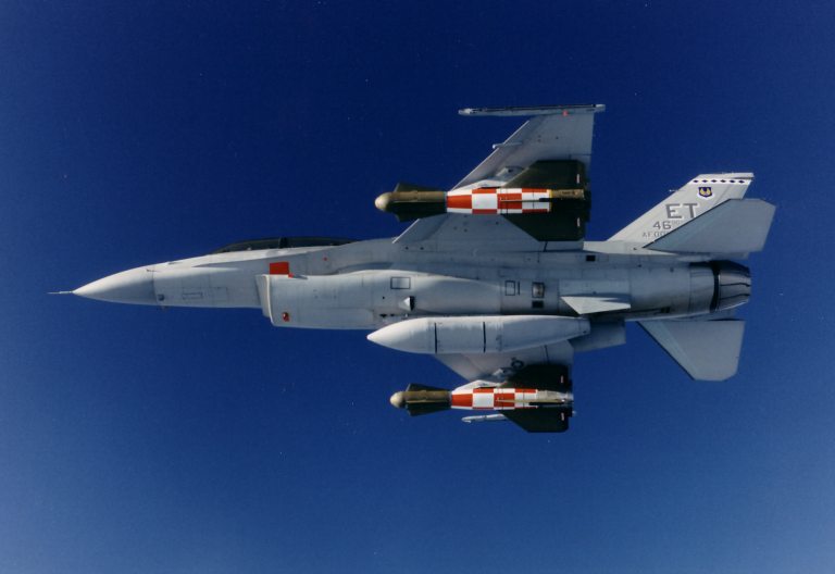 A Block 50 F-16D of the Eglin based 46th Test Wing carrying a pair of EDGE test weapons during captive carry trials. One bomb is measuring its position using standard GPS, the other is using differential GPS updates datalinked to the F-16 from a ground station, using an encrypted channel. The bomb using DGPS achieved accuracies as high as 3.5 ft in horizontal position (USAF). 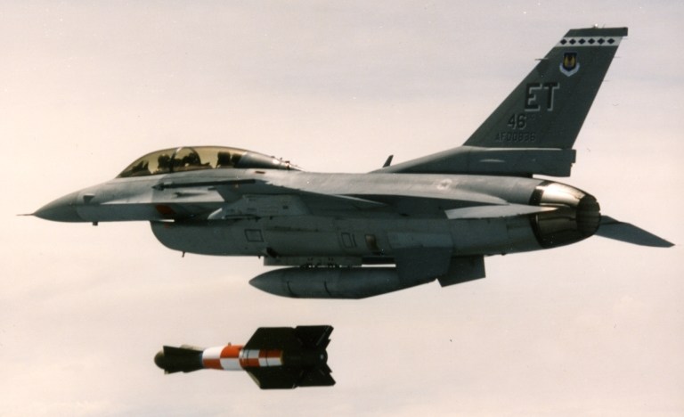 Bomb Away ! One of the six EDGE test weapons is released for a live test. In all six tests, both horizontal and vertical targets were attacked, in classical test range environments as well as a simulated two aircraft operational sortie. Typical bomb accuracy was 4 metres against a horizontal target, the DGPS solution being degraded by multipath effects resulting from antenna and bomb wing interaction (USAF). 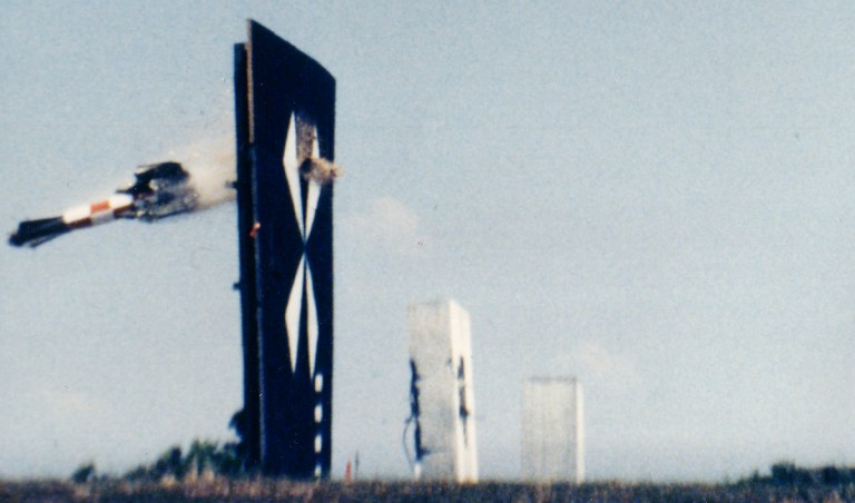 History is made on the third flight test of the EDGE weapon, when the test round impacted within 1.9 metres from the intended aimpoint on the vertical billboard target. This test proved the potential of differential GPS techniques to replace conventional laser guided bombing technology (USAF).   The EGBU-15 Enhanced GBU-15 glidebomb
exploits GPS aided inertial
guidance technology developed during the EDGE program. Later subtypes
of
the GBU-15 derived AGM-130 include GPS capability (US Air Force).
|
|||
|
Trial delivery of an AGM-86C CALCM cruise
missile equipped with Wide-Area GPS Enhancement (GPS) differential GPS
enhancements to its GPS-inertial guidance system. Note the miss
distance against the intended aimpoint [post] (US Air Force).
|
|||
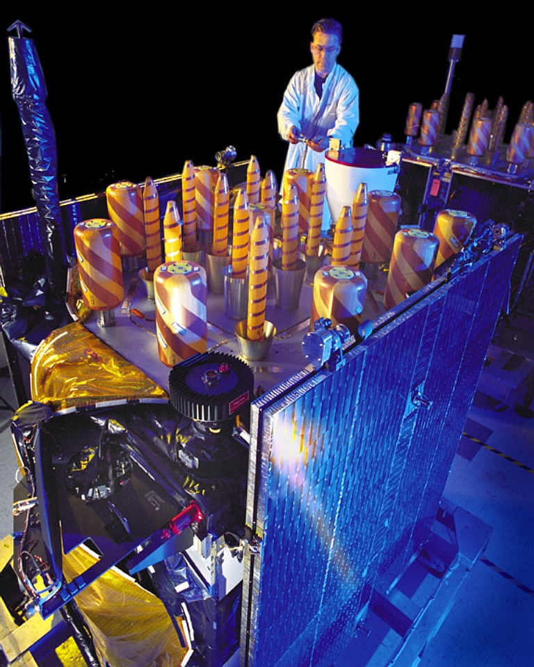 Block IIR SV (US DoD).
|
|||
|
|||||||||||||
|
|
|
|
|
|
|
|
||||||
|
|
|
|
|
|
|
|
||||||
|
|||||||||||||
| Artwork, graphic design, layout and text © 2004 - 2014 Carlo Kopp; Text © 2004 - 2014 Peter Goon; All rights reserved. Recommended browsers. Contact webmaster. Site navigation hints. Current hot topics. | |||||||||||||
|
Site Update
Status:
$Revision: 1.753 $
Site History: Notices
and
Updates / NLA Pandora Archive
|
|||||||||||||
|
|
Tweet | Follow @APA_Updates | |||||||||||
|
|
|||||||||||||
|
|
|||||||||||||


